Altmühl
This article needs additional citations for verification. (March 2016) |
| Altmühl | |
|---|---|
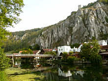
 The Altmühl as part of the Main-Donau-Kanal near Riedenburg | |
 Map with the Altmühl highlighted | |
| Location | |
| Country | Germany |
| Physical characteristics | |
| Source | |
| • location | Middle Franconia |
| Mouth | |
• location | Danube at Kelheim |
• coordinates | 48°54′37″N 11°54′25″E / 48.91028°N 11.90694°ECoordinates: 48°54′37″N 11°54′25″E / 48.91028°N 11.90694°E |
| Length | 226.9 km (141.0 mi) [1] |
| Basin size | 3,258 km2 (1,258 sq mi) [1] |
| Discharge | |
| • average | 24.3 m3/s (860 cu ft/s) |
| Basin features | |
| Progression | Danube→ Black Sea |
The Altmühl (Latin: Alchmona, Alcmana, Almonus)[2] is a river in Bavaria, Germany. It is a left tributary of the river Danube and is approximately 230 kilometres (140 mi) long.
Course[]
The source of the Altmühl is close to the town of Ansbach. From here the river runs southeastwards as a narrow brook to enter the (a lake) north of Gunzenhausen. After leaving Gunzenhausen the river describes a broad curve through the Franconian Jura. It enters the (Altmühl Valley Nature Park), which is known for its natural environment: The meanders of the Altmühl river have cut deep gorges into the mountains of the Franconian Jura.
The Altmühl passes the towns of Treuchtlingen, Eichstätt and Beilngries.
Downriver of Dietfurt the river bed was straightened and integrated into a canal connecting the river Main and the river Danube (the Rhine–Main–Danube Canal). In spite of protests by conservationists the canal was opened in 1992 and has changed much of the eastern Altmühl valley.[3]
The Altmühl finally flows into the Danube in Kelheim.
River[]
The Altmühl rises on the southern slope of the Franconian Ridge northeast of Rothenburg ob der Tauber, near the Hohe Leite and about 500m southeast of the Burgbernheim wilderness Wildbad. As its source, the at Munich in 1904 fixed the drainage ditch of . This is fed by some streams; in the meantime the source of one of them is regarded as Altmühl origin. The Altmühl therefore rises just south of the major European watershed and then flows mainly in southeastern direction. It is the slowest river in Bavaria, flows very slowly, is even one of the slowest German rivers and is also the longest river that rises and flows in the same German state.
The Altmühl can be divided into three parts.
Altmühl above Leutershausen, view to the Frankenhöhe
In the upper third, it is a meadow river slowly flowing in a broad valley. The landscape is flat, slightly hilly and the ground consists mainly of rocks of the Keuper period, here mainly limestone and clay. The mudstone seals the subsoil, therefore, the Altmühl in the upper reaches of a not too broad stream.
In its middle course flows the Altmühl in the north and east on Altmühlsee at Gunzenhausen over. The riverbed was rebuilt here during the construction of the Altmühlsee in the 1980s. On the southern shore of the Altmühlsee, the course of the river crosses the Altmühlüberleiter underground .
Only at high tide does water flow from the Altmühl over the Altmühlzuleiter into the Altmühlsee, which was created as a reservoir for the . This lake is designated as a bird and nature reserve. The water taken from the lake flows through the tunnel of the Altmühlüberleiters first in the small Brombachsee and thus into the river system of the Regnitz north of the continental divide. The flows finally over the Main into the Rhine, so that with the transfer an artificial river bifurcation was created.
Altmühltal at the Burgstein at the Bubenrother mill in morning mist
From Treuchtlingen the Altmühl flows in its lower course through the Franconian Jura plateau , in whose karst limestone she has dug a narrow valley. On the steep valley slopes here sometimes bizarre rock formations. Particularly well are about 20m above the river level lying, kesselelförmige washouts at the village Eßlingen can be seen.
Altmühl near Eichstätt
From Dollnstein the Jura Breakthrough Valley suddenly becomes much wider. From here the Altmühl flows through an earlier valley of the larger Danube. At Rennertshofen this "Urdonautal" branches off from the present Danube valley; in the section where not the Altmühl flows in it, but only small brooks, it is called dry valley.
From the year 1910 the course of the river from was under Wurmsbach downwards straightened and with numerous fortifications regulated, causing many oxbow lakes were cut off. Meanwhile, some of the regulatory measures have been reversed again, such as the Treuchtlinger district Graben and shortly before Eichstätt at Wasserzell.
Their lowest run from was expanded in the middle of the 19th century with 10 barrages to a part of the Ludwig-Danube-Main Canal. The same route was used from 1975 to 1991 for the construction of the Main-Danube Canal , a major shipping route with barrages in Riedenburg and Kelheim. For the first time in a waterway construction project in Europe, landscaping plans for ecological measures were set up in order to replace nature and landscape interventions; 15% of the canal construction costs were spent on this. The Altmühl flows below Kelheim into the Danube at Danube kilometers 2411.54. The well 34 kilometers long Altmühl line is included in the Main-Danube Canal; In addition, there are still 580 meters Altmühl from above the weir Dietfurt to the MDK federal waterway.
Along the Altmühl runs the well-marked and quite well furnished . Canoeing can be done safely on the river itself.
See also[]
References[]
- ^ Jump up to: a b Complete table of the Bavarian Waterbody Register by the Bavarian State Office for the Environment (xls, 10.3 MB)
- ^ Orbis Latinus, s.v.
- ^ Fischer, Ralf (30 July 2012). "20 Jahre geflutet: Der ewig umstrittene Main-Donau-Kanal (German)". Bayerischer Rundfunk.
External links[]
![]() Media related to Altmühl at Wikimedia Commons
Media related to Altmühl at Wikimedia Commons
| hide Authority control | |
|---|---|
| General | |
| National libraries | |
- Tributaries of the Danube
- Altmühl basin
- Rivers of Bavaria
- Federal waterways in Germany
- Rivers of Germany