Ambury Regional Park
| Ambury Regional Park | |
|---|---|
 Lava flow at Ambury Regional Park | |
 | |
 | |
| Location | New Zealand |
| Coordinates | 36°56′53″S 174°45′58″E / 36.9480023°S 174.7662014°ECoordinates: 36°56′53″S 174°45′58″E / 36.9480023°S 174.7662014°E |
| Area | 85 hectares (210 acres) |
| Operated by | Auckland Council |
| Open | Pedestrian access: 24 hours Daylight saving gate hours: 6am-9pm Regular gate hours: 6am-7pm |

Ambury Regional Park (also known as Ambury Farm) is a regional park situated on the coast of Manukau Harbour, in Auckland in New Zealand's North Island. It is situated in the suburb of Māngere Bridge and in the local board area of Māngere-Ōtāhuhu, to the west of Māngere Mountain.[1]
The park is a working sheep and dairy farm with a woolshed and milking shed. There are also goats, cows, pigs, chickens, turkey, rabbits and peacocks.[2][3] Areas of the park are leased to the Mangere Pony Club, and the Ambury Park Centre for Riding Therapy, a charity which opened in 1985, which provides physiological and psychological therapy through horse riding.[4][5]
The parks hosts the Ambury Farm Day each year. It is the largest annual event organised by Auckland Council,[6] and gives families free access to a working farm.[7]
Geography[]
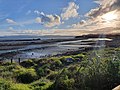
The park covers 85 hectares (210 acres) of low-lying volcanic land on the shores of the upper Manukau Harbour.[8] It includes both wamping coastline and grazed farming paddocks.[9]
There are several examples of basalt lava flows, originating from the Māngere Mountain about 18,000 years ago. Most other lava flows around Auckland have been destroyed during urban development.[10]
There are rare examples of oioi-coastal needle grass on saline margins of lava flows, as well as patches of salt marsh, salt marsh and broadleaved scrub.[10]
Shorebirds migrate to the park in large numbers during summer months. Large numbers of migratory birds feed here during the summer months. Tōrea (South Island pied oystercatcher) and ngutuparore (wrybill) migrate north from the South Island after breeding. Kuaka (bar-tailed godwit) and huahou (red knot) migration from overseas. Kōtuku ngutupapa (royal spoonbill) also migrate to the area.[10]
Birdwatchers have identified a total of 86 birds in the park including little shags, and white-faced herons.[11]
History[]
There is an extensive history of Māori settlement in the Mangere Mountain area, and there are 95 archaeological sites around the park.[12]
Following the start of European settlement, parts of the park were used for sewage treatment. Over 500 hectares (1,200 acres) of oxidation ponds were decommissioned, 13 kilometres (8.1 mi) of shoreline were restored, beaches were constructed, and 27,000 trees were planted in New Zealand's largest coastal restoration project, which was officially completed in 2005.[12]
In 1985, a fuel pipeline between Marsden Point and Auckland Airport was laid through the park. The route is marked by white fenceposts, farm gate tags and triangular marine markers.[9]
In December 1986, the Ambury Regional Park was the site of a large-scale Mongrel Mob convention, where over 300 members attended, during which gang members helped complete the rock retaining walls along the Manukau waterfront.[13] A kidnapping and sexual assault at this event became national news.[14]
The annual Ambury Farm Day began in 1988.[6] By 2009, 35,000 people attended the event.[7] By the early 2000s, the park had become a popular school excursion, with 3-4 schools booked per week visiting the working farm.[4]
A new concept plan for the park was developed in 2009, which included linking it up to nearby walk and cycling tracks. By that stage, 25,000 people were visiting the park each year outside of the annual farm day.[15]
Recreation[]
There are a range of facilities, including public toilets, two wood-fired barbeques, two electric barbeques, and a drinking fountain.[1] The campground can accommodate up to 60 people.[3][16]
Smoking, fires and visible consumption of alcohol are banned. Waste must be taken off-site.[1]
Dogs are allowed on the road portion of the Loop Road, but dogs and other animals are banned from all other parts of the park. Aid dogs are allowed.[1]
Transport[]
The park gates are open 6am to 9pm during daylight saving, and 6pm to 7pm during the rest of the year. Pedestrians can enter and exit the park at any time.[1]
The park is connected by walkway and cycleway to the Mangere Bridge to Onehunga in the north-east,[17] and the Ihumātao to the south.[18] It is a 15 minute walk from the nearest bus stop,[19] and the nearest train station is Onehunga railway station.[17]
Tracks[]
- Ambury Farm Walk (20 minutes, 700 metres) is a short walking track suitable for families,[2] which passes the milkshed, woolshed and animal paddocks.[20]
- Lost Garden's Walk (30 minutes, 1 km) is a walking track which is suitable for mountain buggies but not wheelchairs or prams.[1]
- Family Farm Walk (45 minutes, 1 km) is a track which is suitable for prams and wheelcharis.[1]
- Foreshore Walk (45 minutes, 2 km) is a walking track which is suitable for mountain buggies but not wheelchairs or prams.[1]
- Ambury Mountain Bike Route (45 minutes, 2.5 km) is a tramping and mountain biking track which is not suitable for prams or wheelchairs.[1]
- Kiwi Esplanade walkway (7 km) is a flat walkway and cycleway between Ambury Regional Park and the Ihumātao foreshore.[18][21]
Gallery[]

A clydesdale horse at Ambury Regional Park.
Nesting area for birds at the park.
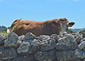
A bull hidden behind a drystone wall at the park.
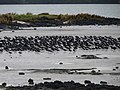
South Island oystercatchers at Ambury Regional Park.


References[]
| Wikimedia Commons has media related to Ambury Regional Park. |
- ^ a b c d e f g h i "Ambury Regional Park". aucklandcouncil.govt.nz. Auckland Council.
- ^ a b "Ambury Farm Path". aucklandcouncil.govt.nz. Auckland Council.
- ^ a b "Best parks to take kids in Auckland". rnz.co.nz. Radio New Zealand.
- ^ a b Payne, Val (2005). "Ambury Regional Farm Park". Celebrating Mangere Bridge. Mangere Historical Society. pp. 110–113. ISBN 0-476-00941-3.
- ^ Payne, Val (2005). "Ambury Park RDA Centre". Celebrating Mangere Bridge. Mangere Historical Society. pp. 97–100. ISBN 0-476-00941-3.
- ^ a b "Ambury Farm Day to return in 2019". Auckland Council. Our Auckland. 3 October 2018.
- ^ a b Colquhoun, Jessie (8 October 2010). "Heaps of fun for all at farm open day". stuff.co.nz. Manukau Courier.
- ^ Harrowell, Chris (30 March 2017). "Ambury Regional Park receives coveted Green Flag Award". stuff.co.nz. Stuff Environment.
- ^ a b Maude, Simon (24 October 2017). "Suburban surprise: Auckland's kilometres-long buried fuel pipeline". stuff.co.nz.
- ^ a b c "Conservation Auckland". tiakitamakimakaurau.nz. Auckland Council.
- ^ "Ambury Regional Park - Auckland". myguideauckland.com. My Guide Auckland.
- ^ a b "Ambury Park: Birdlife rises from sea of waste". New Zealand Media and Entertainment. New Zealand Herald. 11 November 2011.
- ^ Payne, Val. "Community Policing". Celebrating Mangere Bridge. Mangere Historical Society. pp. 105–110. ISBN 0-476-00941-3.
- ^ "12 December 1986". Manukau's Journey - Ngā Tapuwae o Manukau. Auckland Libraries Heritage Collections. MJ_5645. Retrieved 10 October 2021.
- ^ Udanga, Romy (24 July 2009). "Camping plan at Ambury Park". stuff.co.nz. Manukau Courier.
- ^ Hutt, Kendall (28 August 2019). "Father's Day 2019: free or cheap things to do in Auckland with your dad". stuff.co.nz. Stuff Travel.
- ^ a b Freeman, Leonie (23 September 2017). "Best weekend train/walk/bike/beer/coffee combos". New Zealand Media and Entertainment. New Zealand Herald.
- ^ a b "Kiwi Esplanade Walkway". aucklandcouncil.govt.nz. Auckland Council.
- ^ "A day out in Auckland for cost of a public transport fare". Auckland Council. Our Auckland. 20 June 2017.
- ^ "Parks that are easy for everyone to get around". Auckland Council. Our Auckland. 12 September 2017.
- ^ "Parks to see on two wheels". Auckland Council. Our Auckland. 17 December 2019.
- Māngere-Ōtāhuhu Local Board Area
- Parks in the Auckland Region
- Regional parks of New Zealand
- Sheep farming in New Zealand
- Tourist attractions in the Auckland Region
- Protected areas of the Auckland Region
- Shearing sheds