Ruataniwha Conservation Park
| Ruataniwha Conservation Park | |
|---|---|
 Ruataniwha Conservation Park | |
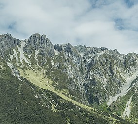
 Ben Ohau Range | |
| Location | New Zealand |
| Nearest town | Twizel |
| Coordinates | 44°00′00″S 169°58′57″E / 43.9999981°S 169.9824904°ECoordinates: 44°00′00″S 169°58′57″E / 43.9999981°S 169.9824904°E |
| Area | 37,145 hectares (91,790 acres) |
| Established | 2006 |
| Governing body | Department of Conservation |

Ruataniwha Conservation Park is a protected area near Twizel, in the Mackenzie District and Canterbury Region of New Zealand's South Island.[1]
The park is managed by the New Zealand Department of Conservation.[1]
Geography[]
The park covers 37,145 hectares (91,790 acres), including Dobson Valley, Hopkins Valley, Huxley Valley, Temple Valley and Maitland Valley and the Ben Ohau Range.[2][1]
History[]
The park was established in 2006.[2]
References[]
- ^ a b c "DOC Profile". doc.govt.nz. Department of Conservation.
- ^ a b Nathan, Simon. "National and conservation parks". Te Ara - the Encyclopedia of New Zealand. Ministry for Culture and Heritage.
This Canterbury Region-related geography article is a stub. You can help Wikipedia by . |
Categories:
- Forest parks of New Zealand
- Parks in Canterbury, New Zealand
- Mackenzie District
- 2006 establishments in New Zealand
- Protected areas established in 2006
- Canterbury, New Zealand geography stubs