Amfilochia
Amfilochia
Αμφιλοχία | |
|---|---|
 | |
 Amfilochia Location within the region  | |
| Coordinates: 38°51′N 21°10′E / 38.850°N 21.167°ECoordinates: 38°51′N 21°10′E / 38.850°N 21.167°E | |
| Country | Greece |
| Administrative region | West Greece |
| Regional unit | Aetolia-Acarnania |
| Area | |
| • Municipality | 1,091.0 km2 (421.2 sq mi) |
| • Municipal unit | 397.9 km2 (153.6 sq mi) |
| Population (2011)[1] | |
| • Municipality | 17,056 |
| • Municipality density | 16/km2 (40/sq mi) |
| • Municipal unit | 10,264 |
| • Municipal unit density | 26/km2 (67/sq mi) |
| Community | |
| • Population | 4,325 (2011) |
| Time zone | UTC+2 (EET) |
| • Summer (DST) | UTC+3 (EEST) |
| Postal code | 305 00 |
| Area code(s) | 26420 |

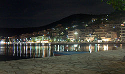
Amfilochia (Greek: Αμφιλοχία) is a town and a municipality in the northwestern part of Aetolia-Acarnania in Greece, on the site of ancient Amfilochia. Under the Ottoman Empire, it was known as Karvasaras (Καρβασαράς; from caravanserai).
Amfilochia is situated by the Ambracian Gulf and features an amphitheatre. Amfilochia dates back to the ancient times and also features the ancient cities of Amphilochian Argos and Limnaia (or Limnaea).
Municipality[]
The municipality Amfilochia was formed at the 2011 local government reform by the merger of the following 3 former municipalities, that became municipal units:[2]
The municipality has an area of 1090.991 km2, the municipal unit 397.879 km2.[3]
Subdivisions[]
The municipal unit of Amfilochia is divided into the following communities:[2]
- Amfilochia (Amfilochia, Boukka, Limnaia and Platos)
- Ampelaki (Ampelaki, Amfilochiko Argos, Ariada, Kampos and Keramidi)
- Anoixiatiko (Anoixiatiko, Agia Triada, Katafourko, Mavrorachi, Moni Retha, Xirolivado, Petralona, Profitis Ilia, Ptelea, Skreiko, Triantafylloula, Tsoukka, Psila Alonia)
- Kechrinia (Kechrinia, Agioi Theodoroi, Kanalos, Kompothekla, Makrychoria, Falangias)
- Loutro (Loutro, Krikellos, Xirakia)
- Megas Kampos
- Sardinia (Sardinia, Kalyvia)
- Sparto (Sparto, Pigadaki, Tria Alonia)
- Stanos
- Varetada
Population[]
| Year | Town | Community | Municipal unit | Municipality |
|---|---|---|---|---|
| 1981 | - | 6,637 | - | - |
| 1991 | 4,392 | - | 13,711 | - |
| 2001 | 4,119 | 4,681 | 12,834 | - |
| 2011 | 3,827 | 4,325 | 10,264 | 17,056 |
Transportation[]
Amfilochia is linked with the GR-5 (E55 and E951, Antirrio - Messolonghi - Ioannina) and is also linked with the GR-42 serving the extreme northwestern parts including Vonitsa, Preveza and the entire island of Lefkada. Amfilochia will be linked with the Ionia Odos. Amfilochia is not linked with a railway.
Notable people[]
- Kyriakos Sfetsas (born 1945), composer
- Nikolaos Stratos (1872–1922), politician and Prime Minister of Greece
- Andreas Stratos (1905–1981), politician and historian
- Vlasios Tsirogiannis, military officer
See also[]
A part of this article is translated from the German Wikipedia
References[]
- ^ a b "Απογραφή Πληθυσμού - Κατοικιών 2011. ΜΟΝΙΜΟΣ Πληθυσμός" (in Greek). Hellenic Statistical Authority.
- ^ a b "ΦΕΚ B 1292/2010, Kallikratis reform municipalities" (in Greek). Government Gazette.
- ^ "Population & housing census 2001 (incl. area and average elevation)" (PDF) (in Greek). National Statistical Service of Greece. Archived from the original (PDF) on 2015-09-21.
External links[]
- Municipality of Amfilochia (in Greek)
- Amfilochia (municipality) information
- Amfilochia (town) information
| Regional unit of Achaea | 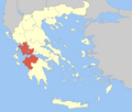 | |
|---|---|---|
| Regional unit of Aetolia-Acarnania | ||
| Regional unit of Elis | ||
| ||
This Western Greece location article is a stub. You can help Wikipedia by . |
- Municipalities of Western Greece
- Populated places in Aetolia-Acarnania
- Mediterranean port cities and towns in Greece
- Acarnania
- Western Greece geography stubs