Agrinio
Agrinio
Αγρίνιο | |
|---|---|
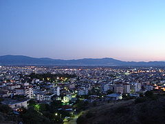
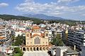
 Panorama of Agrinio. | |
 Seal | |
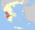
 Agrinio show Location within the region | |
| Coordinates: 38°37′N 21°24′E / 38.617°N 21.400°ECoordinates: 38°37′N 21°24′E / 38.617°N 21.400°E | |
| Country | Greece |
| Administrative region | West Greece |
| Regional unit | Aetolia-Acarnania |
| Government | |
| • Mayor | Georgios Papanastasiou (New Democracy) |
| Area | |
| • Municipality | 1,229.33 km2 (474.65 sq mi) |
| • Municipal unit | 162.73 km2 (62.83 sq mi) |
| Elevation | 91 m (299 ft) |
| Population (2011)[1] | |
| • Municipality | 106,053 |
| • Municipality density | 86/km2 (220/sq mi) |
| • Municipal unit | 59,329 |
| • Municipal unit density | 360/km2 (940/sq mi) |
| Community | |
| • Population | 59,329 (2011) |
| Time zone | UTC+2 (EET) |
| • Summer (DST) | UTC+3 (EEST) |
| Postal code | 301 00 |
| Area code(s) | 26410 |
| Vehicle registration | ΑΙ |
| Website | https://agrinio.gov.gr/ |


Agrinio (Greek: Αγρίνιο, pronounced [aˈɣrinio], Latin: Agrinium) is the largest city of the Aetolia-Acarnania regional unit of Greece and its largest municipality, with 106,053 inhabitants. It is the economical center of Aetolia-Acarnania, although its capital is the town of Mesolonghi. The settlement dates back to ancient times. Ancient Agrinion was 3 kilometres (2 miles) northeast of the present city; some walls and foundations of which have been excavated. In medieval times and until 1836, the city was known as Vrachori (Βραχώρι).
The majority of the local population was occupied for an important period of time in the tobacco industry, from the last decades of 19th till the end of the 20th century. Big tobacco companies were founded in the city, including the famous Papastratos, alongside Panagopoulos and Papapetrou. Agrinion is also agriculturally known for its production of Agrinion olives.
History[]
Antiquity[]

According to mythology, the ancient city of Agrinio (situated in the area of ) was built by king Agrios, son of Portheus[2] and a great grandson of Aetolos (king of Plevron and Calydon) around 1600-1100 BC. The town, built near the banks of river Achelous (the natural border between Aetolia and Acarnania), was claimed by both states during ancient times. Agrinio became member of the Aetolian League and it was later destroyed by Cassander in 314 BC during the League's wars against the Kingdom of Macedonia.
Ottoman Era[]
The city reappears during the Ottoman period with the name Vrachori and apart from its Greek population it was also inhabited by many Turks (Muslims). In 1585 it was deserted during the revolt of . At the beginning of the 18th century it became the administrative centre of Aetolia-Acarnania (then as the sanjak of Karleli), depended on the imperial harems. Vrachori participated in the Greek Revolution and was temporarily liberated, by an army group led by Alexakis Vlachopoulos, on June 11, 1821. In August 1822, while Reşid Mehmed Pasha's (Kütahi) troops were marching towards Vrachori, its citizens decided to burn and evacuate their city, following the strategy of scorched earth. The deserted city was recaptured by the Turks. The city was finally included in the borders of the newborn Greek state permanently in 1832 with the Treaty of Constantinople (July 9, 1832) and was renamed after its ancient name, Agrinion.
Modern Era[]


In the years following the liberation, Agrinio went through an important growth and development, especially at the end of the 19th century and the dawn of the 20th. After the Greco-Turkish War and the Asia Minor Catastrophe, many refugees from Asia Minor (western Turkey) arrived in the city and settled in the district of Agios Konstantinos. At the same period there was an important internal immigration to Agrinio from the whole Aetolia-Acarnania region, along with immigration from the areas of Epirus and Evrytania.
During the Interwar period, in spite of economical crisis, works of infrastructure took place in the city, like the paving of streets and the installment of electricity, while a water tower was installed in 1930. At the same time excavations revealed the ancient city of Agrinion. Growth and prosperity returned after World War II and the Greek Civil War. This growth was boosted by the building of two major hydroelectric dam installations at Kremasta and Kastraki, on the north of the city. The tobacco industry and olive tree cultivation became the main income sources of the city.
Climate[]
The climate of Agrinio is mediterranean (Csa) with a big amount of rainfall during the short winter and high temperatures in the summer, sometimes over 40 °C (104 °F).
On April 10, 2007 the city was struck by several earthquakes, with their epicenter located in the nearby Lake Trichonis on the southeast of the city. The first earthquake rumbled at around 2:20 AM, the second around 6:15 AM, three earthquakes shook at 10:13, 10:14 and 10:15 AM, and the last one at around 13:45 PM, they measured between 5.0 and 5.7 on the Richter scale. Residents reported that the buildings and its glasses were shaking and rumbling. Minor damages were reported without any victims.
On June 7, 2007 a low pressure-system including heavy torrential rains arrived from Southern and Central Europe stranding several people, and caused flooding in several buildings.
| hideClimate data for Agrinio (1956–1997) | |||||||||||||
|---|---|---|---|---|---|---|---|---|---|---|---|---|---|
| Month | Jan | Feb | Mar | Apr | May | Jun | Jul | Aug | Sep | Oct | Nov | Dec | Year |
| Average high °C (°F) | 13.6 (56.5) |
14.5 (58.1) |
16.9 (62.4) |
20.5 (68.9) |
25.9 (78.6) |
30.4 (86.7) |
33.2 (91.8) |
33.6 (92.5) |
29.8 (85.6) |
24.4 (75.9) |
18.9 (66.0) |
14.8 (58.6) |
23.0 (73.4) |
| Daily mean °C (°F) | 8.3 (46.9) |
9.2 (48.6) |
11.5 (52.7) |
15.1 (59.2) |
20.3 (68.5) |
24.7 (76.5) |
27.1 (80.8) |
26.9 (80.4) |
23.0 (73.4) |
17.9 (64.2) |
13.1 (55.6) |
9.6 (49.3) |
17.2 (63.0) |
| Average low °C (°F) | 3.4 (38.1) |
3.9 (39.0) |
5.6 (42.1) |
8.3 (46.9) |
12.3 (54.1) |
15.6 (60.1) |
17.5 (63.5) |
17.7 (63.9) |
15.0 (59.0) |
11.5 (52.7) |
8.0 (46.4) |
4.9 (40.8) |
10.3 (50.5) |
| Average precipitation mm (inches) | 116.4 (4.58) |
109.3 (4.30) |
82.8 (3.26) |
60.6 (2.39) |
42.9 (1.69) |
22.1 (0.87) |
14.2 (0.56) |
15.3 (0.60) |
46.8 (1.84) |
100.5 (3.96) |
160.0 (6.30) |
160.3 (6.31) |
931.2 (36.66) |
| Average precipitation days | 13.1 | 12.5 | 12.4 | 11.6 | 8.6 | 4.4 | 2.4 | 3.2 | 5.3 | 9.4 | 12.9 | 15.8 | 111.6 |
| Average relative humidity (%) | 75.1 | 72.8 | 70.0 | 68.0 | 63.2 | 57.5 | 55.1 | 55.9 | 63.0 | 69.7 | 77.6 | 78.4 | 67.2 |
| Mean monthly sunshine hours | 126.9 | 132.4 | 173.5 | 201.7 | 261.4 | 325.1 | 360.1 | 330.0 | 259.9 | 196.4 | 140.7 | 117.2 | 2,625.3 |
| Source: Hellenic National Meteorological Service[3] | |||||||||||||
Transportation[]
The main roads passing through Agrinio are the Greek National Road 5/E55 (Arta – Agrinio – Missolonghi) and the Greek National Road 38/E952 (Thermo – Agrinio – Karpenisi). Since 2009 the new Motorway 5 bypasses Agrinio to the west.
Agrinio's airport is located near the city, in the area of Dokimi. IATA code: AGQ, ICAO: LGAG. The airport hosts the Agrinion aeroclub Agrinion Aeroclub, website.
Municipality[]


The extended municipality Agrinio was formed at the 2011 local government reform by the merger of the following 10 former municipalities, that became municipal units:[4]
- Agrinio
- Angelokastro
- Arakynthos
- Makryneia
- Neapoli
- Panaitoliko
- Parakampylia
- Paravola
- Stratos
- Thestieis
The municipality has an area of 1229.330 km2, the municipal unit 162.728 km2.[5]
Subdivisions[]
The municipal unit (former municipality) of Agrinio consists of the following communities:
- Agios Konstantinos
- Agios Nikolaos Trichonidos
- Agrinio
- Dokimi
- Kalyvia
- Kamaroula
- Skoutesiada
The city of Agrinio consists of the main city and the outlying villages Agios Ioannis Riganas, Akropotamos, Bouzi, Giannouzi, Diamanteika, Eleftheria, Lefka, Liagkaiika, Pyrgi, Schinos and Strongylaiika.
City Seal[]
The city's official seal includes a characteristic moment of the ancient Greek mythology. More specifically, the seal depicts Hercules fighting the river-god Achelous. According to the myth, Hercules fought against the river-god for the sake of Diianira, the princess of Calydon, which both of them wanted as a wife. Despite Achelous' transformations, Hercules managed to win the battle and married the princess. According to Strabo, the myth symbolises the struggle of ancient Aetolians to control the river's power with embankments, by which the river was confined to its bed and thus the area gained large tracts of land for cultivation.
Historical population[]
| Year | Town | Municipal unit | Municipality |
|---|---|---|---|
| 1971 | 32,190 | 39,667 | - |
| 1981 | 35,773 | 45,087 | - |
| 1991 | 39,638 | 52,081 | - |
| 2001 | 42,390 | 54,523 | - |
| 2011 | 48,645 | 59,329 | 94,181 |
Landmarks[]


- The Archaeological Museum of Agrinion, located in the city center, at 1-2 Diamantis Street. website
- The neoclassical buildings of the tobacco storehouses Papastratos and Papapetrou, which date from the early 20th century.
- The Papastrateio Municipal Park.
- The Papastratios Municipal Library.
- The Dimokratias Square, the main square of the city.
- The remains of the Church of the Holy Trinity of Mavrika (8th-9th century), situated at the banks of lake Lysimachia.
- Lakes Trichonida and Lysimachia.
- The ancient city of Stratos.
- The gorge of Kleisoura, on the old national road, 15 kilometres (9 miles) south of the city.
- The hydroelectric dams of Kremasta, Kastraki and Stratos.
Mayors[]
- Georgios Baibas (1899–1907)
- Andreas Panagopoulos (1925–1934 and 1951–1952)
- Dimitrios Votsis (1934–1941)
- Anastasios Panagopoulos (1964–1967)
- Stelios Tsitsimelis (1975–1986)
- Giannis Vainas (1986–1994)
- Thimios Sokos (1994–2006)
- Pavlos Moscholios (2006–2014)
- Georgios Papanastasiou (2014–present)
Famous citizens[]

- Stratos Apostolakis (1964) – footballer
- Petros Michos (1959) – footballer
- (1868–1920) – poet
- (1959) – writer
- – actress
- Panagiotis Danglis (1853–1924) – general and politician
- Filipos Darlas (1983) – footballer
- Maria Dimadi (1907–1944) – resistance fighter
- Petros Fyssoun (1933) – actor
- (1947) – poet & writer
- Christos Kapralos (1909–1993) – artist
- Michalis Kousis (1953–2005) – Marathon runner
- Aristidis Moschos (1930–2001) – musician
- Pythagoras Papastamatiou (1930–1979) – writer
- Thodoros (1931–2018) – sculptor
- Evangelos Papastratos (1910–1988) – industrialist and benefactor of Agrinio
- – actress
- (1949) – poet
- Kostis Maraveyas (1974) – singer and composer
- Spiros and Eleni Tsiknia – Benefactors of Agrinio
Sporting teams[]

- Panetolikos FC – Super League Greece
- Gymnastiki Etairia Agriniou (G.E.A.)
- A.O. Agriniou
- Ionikos 80 Volleyball
- Nautikos Omilos
- Asteras Agriniou
- PAO Agriniou
Gallery[]
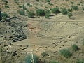
The ancient theatre of Calydon near the city
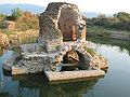
Agia Triada Mavrika Byzantine church
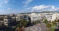
Central square
Agios Christoforos church

Agrinio Archaeological museum

Old railway station

Rural area in the municipality of Agrinio
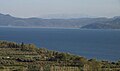
Trichonida Lake

Voukatio castle, Paravola


See also[]
- List of settlements in Aetolia-Acarnania
- List of ancient Greek cities
References[]
- ^ Jump up to: a b "Απογραφή Πληθυσμού - Κατοικιών 2011. ΜΟΝΙΜΟΣ Πληθυσμός" (in Greek). Hellenic Statistical Authority.
- ^ Gerasimos Papatrehas, "The history of Agrinion", Municipality of Agrinion, 1991
- ^ "Agrinio Climatological data 1956–1997". Hellenic National Meteorological Service. Archived from the original on 22 February 2011. Retrieved 1 May 2015.
- ^ "ΦΕΚ B 1292/2010, Kallikratis reform municipalities" (in Greek). Government Gazette.
- ^ "Population & housing census 2001 (incl. area and average elevation)" (PDF) (in Greek). National Statistical Service of Greece. Archived from the original (PDF) on 2015-09-21.
External links[]
| Look up agrinio in Wiktionary, the free dictionary. |
| Wikimedia Commons has media related to Agrinio. |
- Official site
- Richard Stillwell, ed. Princeton Encyclopedia of Classical Sites, 1976: "Agrinion Greece"
- www.agriniovoice.gr, local news
- Agrinio City Guide
| Authority control |
|---|
- Agrinio
- Cities in ancient Greece
- Aetolia
- Populated places in Aetolia-Acarnania