April 2007 nor'easter
Category 1 "Notable" (RSI/NOAA: 1.167) | |
 Satellite imagery of the nor'easter impacting the Northeastern United States on April 16 | |
| Type | Extratropical cyclone Nor'easter |
|---|---|
| Formed | April 13, 2007 |
| Dissipated | April 17, 2007 |
| Lowest pressure | 969[1] mb (28.61 inHg) |
| Tornadoes confirmed | 36 |
| Max. rating1 | EF3 tornado |
| Maximum snowfall or ice accretion | 23.0 inches (58.42 centimeters) |
| Casualties | At least 18 |
| Damage | $264 million (2007 USD) |
| Areas affected | East Coast of the United States, Eastern Canada |
Part of the Winter storms of 2006–07 1Most severe tornado damage; see Enhanced Fujita scale | |
The April or Spring nor'easter of 2007 was a nor'easter that affected mainly the eastern parts of North America during its four-day course, from April 14 to April 17, 2007. The combined effects of high winds, heavy rainfall, and high tides led to flooding, storm damages, power outages, and evacuations, and disrupted traffic and commerce. In the north, heavy wet snow caused the loss of power for several thousands of homes in Ontario and Quebec. The storm caused at least 18 fatalities.
Meteorological history[]
The storm that would become the April 2007 nor'easter started out in the Southwestern United States, as an upper-level disturbance in the jet stream, on April 13.[1] It brought high wind and fire danger to California, Nevada, New Mexico and Arizona. The storm then moved out into the southern Plains States, bringing heavy snow to Colorado, Oklahoma, and Texas. Heavy rain and severe thunderstorms, with hail, wind, and tornadoes, affected parts of Texas, Louisiana, Mississippi, Alabama, Georgia, Florida, and the Carolinas. The storm then moved across the Mid-Atlantic States, and into the Atlantic Ocean, following the East Coast. The storm then rapidly intensified into a major nor'easter, with the warm waters of the Gulf Stream. The storm stalled just offshore from New York City and continued to strengthen. The lowest barometric pressure recorded was 968 millibars (28.58 in Hg), equivalent to that of a moderate Category 2 hurricane.[1]
Impact[]

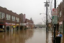
The National Weather Service reported 7.57 inches (192 mm) of rain in Central Park by midnight of April 15, the second heaviest rainfall in 24 hours on record, and indicated that this storm caused the worst flooding since Hurricane Floyd in 1999.[2] Major airports in the New York area resumed flights on April 16, after having had to cancel over 500 flights before. Local rail and transit lines reported delays and cancellations affecting the MTA, NJ Transit, LIRR, and Metro-North Railroad. Power failures affected several thousand people.[2]
On April 16, 2007, the storm caused sustained winds of nearly 100 mph (87 knots) on, and near New Hampshire's Mount Washington, with gusts topping out at 156 mph (136 knots).[3]

While areas closer to the shore received heavy rainfall, higher regions inland received unseasonal snow.[4] Several towns suffered from flooding including Mamaroneck in New York, and Bound Brook and Manville in New Jersey, while coastal towns had to deal with damage from high tides. Most major highways in Westchester County, New York were closed on April 15 and April 16 due to extreme flooding. In Quebec, several regions including the Laurentides and Charlevoix regions received in excess of 6 inches (15 cm) of snow with areas exceeding well above 1 foot (30 cm) of snow. In the city of Ottawa, 17 cm (5 in) of heavy wet snow fell in just a few hours causing power lines and trees to fall down causing scattered blackouts in several parts of the city.[5] Similar damage was reported in the higher elevations north of Montreal and Ottawa.
In total, more than 175,000 homes in Canada suffered a power outage, including 160,000 Hydro-Québec customers mainly in areas from Gatineau towards Quebec City including Montreal, Lanaudière and the Laurentians with an additional 15,000 Hydro One and Hydro Ottawa customers.[6] In the US over a quarter million homes lost power with New York and Pennsylvania being the hardest hit states due to the strong winds.
Governor Eliot Spitzer of New York activated 3,200 members of the National Guard on alert. Richard Codey, acting governor of New Jersey, declared a state of emergency.[7]
The storm was blamed for several fatalities, including one person in a tornado in South Carolina, two people in storm-related traffic accidents in New York and Connecticut,[8] two people in West Virginia, three people in New Jersey,[9] and prior to its arrival in the East, five deaths in Kansas and Texas.[2] In Quebec, an accident between a van and a tractor trailer killed five occupants of the van in a highway north of Montreal.[10] Numerous other accidents were reported by OPP and the Sûreté du Québec during the storm.
The Boston Marathon took place in what many considered to be the worst weather in its 110-year history. Race officials held serious talks about whether or not to cancel the race.[11] The men's race had the slowest winning time in thirty years (1977). In the women's race, "[t]he rainy and windy conditions led to the slowest winning time since 1985".[12]
High winds during the storm prevented emergency medical services from using helicopters for evacuation of the injured at the Virginia Tech massacre.[13]
The Internal Revenue Service delayed by two days the deadline for tax filing for victims of the nor'easter.[14]
While filing for federal disaster relief, acting governor Codey of New Jersey indicated that the storm caused $180 million in property damage in New Jersey, making it the second-worst rain storm in its history, after Hurricane Floyd.[9]
Tornadoes[]
Confirmed tornadoes[]
| EFU | EF0 | EF1 | EF2 | EF3 | EF4 | EF5 | Total |
|---|---|---|---|---|---|---|---|
| 0 | 15 | 16 | 4 | 1 | 0 | 0 | 36 |
April 13 event[]
| EF# | Location | County | Time (UTC) | Path length | Damage | |
|---|---|---|---|---|---|---|
| Texas | ||||||
| EF0 | NE of Rule | Haskell | 1845 | 1 miles (1.6 km) |
Brief tornado crossed Highway 6 and caused no damage.[15] | |
| EF0 | S of Seymour | Baylor | 1938 | 6 miles (9.6 km) |
This large wedge tornado remained over open country, though it was likely capable of causing major damage.[16] | |
| EF0 | S of Benbrook | Tarrant | 2255 | 2 miles (3.2 km) |
Tornado damaged fences, trees, and street signs. The facade of a business was also slightly damaged.[17] | |
| EF1 | Fort Worth/Haltom City | Tarrant | 2309 | 6 miles (9.6 km) |
1 death - Substantial roof damage was done to a grocery store, several homes, and a church. Another church suffered steeple damage, and commercial buildings were also damaged, including one that sustained total collapse of an east-facing wall. Tractor-trailers were damaged or destroyed, and numerous trees and power lines were downed as well.[18] | |
| EF0 | Dallas | Dallas | 0000 | 1 miles (1.6 km) |
Several trees, tree limbs, and fences were downed in a residential area, and apartment buildings sustained roof damage.[19] | |
| EF0 | S of Royse City | Rockwall | 0045 | 2 miles (3.2 km) |
Two barns were destroyed and fences were downed.[20] | |
| EF0 | SW of Greenville | Hunt | 0053 | unknown | Brief tornado caused damage to trees.[21] | |
| Source: NCDC Storm Data | ||||||
April 14 event[]
| EF# | Location | County | Time (UTC) | Path length | Damage | |
|---|---|---|---|---|---|---|
| Mississippi | ||||||
| EF0 | N of | Marion | 1510 | unknown | Trees were snapped and large limbs were blown down.[22] | |
| EF0 | SE of | Jones | 1535 | unknown | Brief tornado remained in rural areas with no damage.[23] | |
| EF1 | SE of Petal | Forrest | 1641 | 1 miles (1.6 km) |
One home had significant damage with the carport being destroyed and other damage to sidings, roof and windows. Trees were snapped or uprooted and a power pole also snapped.[24] | |
| Alabama | ||||||
| EF1 | S of Vredenburgh | Monroe | 1833 | 1 miles (1.6 km) |
Two churches were damaged, and an old home was pushed off of its blocks and lost its roof. Trees were downed in a convergent pattern. A microburst in the area preceded the tornado.[25] | |
| EF0 | NW of | Crenshaw | 2100 | 1 miles (1.6 km) |
Rope tornado damaged the tin roofs of three buildings on a poultry farm. A church had shingles taken off and a tree fell onto the roof.[26] | |
| EF1 | NW of Castleberry | Conecuh | 2212 | unknown | One residence was damaged and trees were blown down. | |
| EF1 | W of | Bullock | 2311 | 3 miles (4.8 km) |
One barn was destroyed and several homes had minor roof damage. Trees were snapped and uprooted as well.[27] | |
| EF1 | N of Ozark | Dale | 0005 | 6 miles (9.6 km) |
A carport, two sheds, a barn and a greenhouse were destroyed. A residential gable collapsed, and several homes sustained moderate damage in the community of . Trees were downed as well, including one that landed on a house.[28] | |
| Georgia | ||||||
| EF0 | N of Morgan | Calhoun | 0145 | 1 miles (1.6 km) |
One structure was damaged and numerous trees were knocked down.[29] | |
| EF1 | NW of Leesburg | Lee | 0230 | 2 miles (3.2 km) |
Fifteen structures were damaged, including a mobile home and a frame home being destroyed. Numerous trees and power lines were downed as well. | |
| EF1 | Eastman | Dodge | 0523 | 4 miles (6.4 km) |
A greenhouse, an announcers booth at a football field and two mobile homes were destroyed. Several retain buildings sustained minor damage as well. One home was destroyed by a fallen tree, injuring both occupants. Numerous trees and power lines were downed, some of which landed on homes and caused damage.[30] | |
| EF2 | S of Dublin | Laurens | 0545 | 6 miles (9.6 km) |
Two mobile homes and a greenhouse were destroyed. The carport of a site-built home was removed as well as a portion of the roof. Several other mobile homes and site-built homes sustained minor damage from wind and fallen trees. 3 people were injured.[31] | |
| EF0 | NE of Cedar Grove | Laurens | 0550 | 6 miles (9.6 km) |
Outbuildings were damaged and numerous trees were downed.[32] | |
| EF1 | SE of Orland to NW of | Treutlen, Emanuel, Johnson | 0604 | 14 miles (22.4 km) |
One mobile home was rolled over and a utility building lost portions of its roof. About a dozen homes in Adrian were damaged. Two homes at a campground were also damaged due to fallen trees. In , two homes were heavily damaged and outbuildings were destroyed. A mobile home was also destroyed in Emanuel County near the end of the path.[33] | |
| EF1 | SE of Dublin to SW of Kite | Laurens, Johnson | 0605 | 19 miles (30.4 km) |
Outbuildings were destroyed and numerous trees and power lines were downed. Several homes and a church sustained minor damage, and a family life center was shifted off of its foundation.[34] | |
| EF2 | E of Twin City | Emanuel | 0656 | 5 miles (8 km) |
Two homes lost a significant portion of their roofs and outer walls. A mobile home was also damaged and some nearby outbuildings were destroyed.[35] | |
| EF1 | S of Warwick to NE of Arabi | Worth, Crisp | 0723 | 15 miles (24 km) |
A home and several silos were damaged while trees and power lines were downed. A mobile home was also pushed off its foundation while a car was thrown into a guard rail on Interstate 75.[36] | |
| Source: NCDC Storm Data | ||||||
April 15 event[]
| EF# | Location | County | Time (UTC) | Path length | Damage | |
|---|---|---|---|---|---|---|
| Georgia | ||||||
| EF2 | SE of Eastman | Dodge | 0825 | 4 miles (6.4 km) |
Two mobile homes, a barn and a garage were destroyed while several homes sustained minor to heavy damage.[37] | |
| Florida | ||||||
| EF2 | NW of | Baker | 1115 | 2 miles (3.2 km) |
A house sustained minor damage and an outbuilding was destroyed. Widespread tree damage occurred as well.[38] | |
| EF1 | NW of Summer Haven | St. Johns | 1410 | unknown | Boat house roofs were blown off, and trees were snapped. Buildings had windows blown out and pieces of lumber embedded into them. Signs were bent over at 45-degree angles.[39] | |
| EF0 | Dundee | Polk | 1600 | 2 miles (3.2 km) |
Several manufactured homes were damaged to various degrees, and some were left uninhabitable.[40] | |
| South Carolina | ||||||
| EF0 | E of | Bamberg | 1147 | 8 miles (12.8 km) |
Damage to trees and power lines occurred.[41] | |
| EF0 | E of Ehrhardt | Bamberg | 1211 | 4 miles (6.4 km) |
Damage was limited to trees.[42] | |
| EF3 | NW of Pinewood to NW of Mayesville | Sumter | 1220 | 19 miles (30.4 km) |
1 death - Seven mobile homes were destroyed, nine frame homes were severely damaged while 62 mobile and frame homes were damaged at varying degrees. 5 other people were injured.[43] | |
| EF1 | E of St. Charles | Lee | 1250 | 4 miles (6.4 km) |
Tornado downed numerous trees, a few powerlines, and did minor damage to a church and a mobile home.[44] | |
| EF0 | N of Bowman | Orangeburg | 1337 | 6 miles (9.6 km) |
Damage to trees and power lines occurred.[45] | |
| EF1 | S of Islandton | Colleton | 1338 | 1 miles (1.6 km) |
Hundreds of trees and power lines were downed, and a large barn was destroyed with debris scattered up to a half-mile away. A house sustained window, brick veneer, and siding damage. A large 8000 pound horse trailer was lifted up and carried 500 feet, and an 800-pound grain wagon was lifted and carried 400 feet. A bass boat was flipped over and a 4-wheeler was damaged along with other farm equipment. A tree also fell on a mobile home as well.[46] | |
| EF1 | SE of Islandton | Colleton | 1341 | 1 miles (1.6 km) |
Tornado carried two empty grain silos about 100 feet, snapped off or uprooted dozens of trees, destroyed a large portion of an outbuilding, and severely injured a dog.[47] | |
| EF1 | SW of Ruffin | Colleton | 1344 | 8 miles (12.8 km) |
Tornado overturned 3 mobile homes and shifted another 7 mobile homes off of their foundations. It tore the skirting away from another mobile home, destroyed a storage shed, and snapped off or uprooted dozens of trees. A couple of trees fell on a house. A vehicle and an outbuilding were also damaged. 9 people were injured.[48] | |
| Source: NCDC Storm Data | ||||||
See also[]
References[]
- ^ Jump up to: a b c NWC (2007). "Spring 2007 Nor'easter". NOAA. Retrieved 2008-01-21.
- ^ Jump up to: a b c Robert McFadden (2007-04-16). "East Coast Storm Breaks Rainfall Records". The New York Times. Retrieved 2007-04-26.
- ^ Patriot's Day Storm Packs a 156-mph Punch. Archived 2007-10-11 at the Wayback Machine Mount Washington Observatory. Retrieved on 2007-04-26
- ^ A spring to remember Archived 2007-09-27 at the Wayback Machine Rutland Herald (April 17, 2007). Retrieved on 2007-04-30
- ^ Heavy snow brings cancellations, frustration. Archived 2012-10-25 at the Wayback Machine Ottawa Citizen (April 16, 2007). Retrieved on 2007-04-26
- ^ More than 100,000 without power as storm hits Ontario, Quebec. CBC News (April 16, 2007). Retrieved on 2007-04-26
- ^ "Storm brings evacuations, road closings in New Jersey". Home News Tribune. Associated Press. 2007-04-16. Archived from the original on 2007-09-27. Retrieved 2007-04-26.
- ^ Karen Matthews (2007-04-16). "3 Deaths blamed on East Coast Storm". abcnews.go.com. Archived from the original on 6 June 2007. Retrieved 2007-04-26.
- ^ Jump up to: a b Lorin, Janet Frankston (AP writer) (2007-04-26). "Storm damage pegged at $180M". Home News Tribune.
- ^ Le tragique accident a fait cinq victimes. LCN Quebecor media, April 17, 2007. (in French) Retrieved on 2007-04-27.
- ^ Marcus, Jon (April 13, 2008). "The Marathon They Almost Canceled". The Boston Globe.
- ^ 111th Boston Marathon Race Day Commentary. Archived 2007-05-18 at the Wayback Machine Boston Athletic Association. Retrieved on 2007-05-02
- ^ Holley, Joe (2007-04-16). "Students Recount Shootings". The Washington Post. Retrieved 2007-05-02.
- ^ "IRS Gives April 16 Storm Victims Additional 48 Hours to File Income Tax Returns" (Press release). Internal Revenue Service. 2007-04-16. Archived from the original on 19 April 2007. Retrieved 2007-04-26.
- ^ "Storm Events Database - Event Details | National Centers for Environmental Information".
- ^ "Storm Events Database - Event Details | National Centers for Environmental Information".
- ^ "Storm Events Database - Event Details | National Centers for Environmental Information".
- ^ "Storm Events Database - Event Details | National Centers for Environmental Information".
- ^ "Storm Events Database - Event Details | National Centers for Environmental Information".
- ^ "Storm Events Database - Event Details | National Centers for Environmental Information".
- ^ "Storm Events Database - Event Details | National Centers for Environmental Information".
- ^ "Storm Events Database - Event Details | National Centers for Environmental Information".
- ^ "Storm Events Database - Event Details | National Centers for Environmental Information".
- ^ "Storm Events Database - Event Details | National Centers for Environmental Information".
- ^ "Storm Events Database - Event Details | National Centers for Environmental Information".
- ^ "Storm Events Database - Event Details | National Centers for Environmental Information".
- ^ "Storm Events Database - Event Details | National Centers for Environmental Information".
- ^ "Storm Events Database - Event Details | National Centers for Environmental Information".
- ^ "Storm Events Database - Event Details | National Centers for Environmental Information".
- ^ "Storm Events Database - Event Details | National Centers for Environmental Information".
- ^ "Storm Events Database - Event Details | National Centers for Environmental Information".
- ^ "Storm Events Database - Event Details | National Centers for Environmental Information".
- ^ "Storm Events Database - Event Details | National Centers for Environmental Information".
- ^ "Storm Events Database - Event Details | National Centers for Environmental Information".
- ^ "Storm Events Database - Event Details | National Centers for Environmental Information".
- ^ "Storm Events Database - Event Details | National Centers for Environmental Information".
- ^ "Storm Events Database - Event Details | National Centers for Environmental Information".
- ^ "Storm Events Database - Event Details | National Centers for Environmental Information".
- ^ "Storm Events Database - Event Details | National Centers for Environmental Information".
- ^ "Storm Events Database - Event Details | National Centers for Environmental Information".
- ^ "Storm Events Database - Event Details | National Centers for Environmental Information".
- ^ "Storm Events Database - Event Details | National Centers for Environmental Information".
- ^ "Storm Events Database - Event Details | National Centers for Environmental Information".
- ^ "Storm Events Database - Event Details | National Centers for Environmental Information".
- ^ "Storm Events Database - Event Details | National Centers for Environmental Information".
- ^ "Storm Events Database - Event Details | National Centers for Environmental Information".
- ^ "Storm Events Database - Event Details | National Centers for Environmental Information".
- ^ "Storm Events Database - Event Details | National Centers for Environmental Information".
External links[]
| Wikimedia Commons has media related to April 2007 Nor'easter. |
- Natural disasters in South Carolina
- Natural disasters in Pennsylvania
- Natural disasters in New Jersey
- Natural disasters in New York (state)
- Natural disasters in Connecticut
- Natural disasters in Ontario
- Natural disasters in Quebec
- 2007 meteorology
- Natural disasters in Virginia
- Nor'easters
- 2007 natural disasters in the United States
- 2007 in Quebec
- December 2007 events in North America
- 2007 disasters in Canada