Arcadia Planitia
 | |
| Coordinates | 47°12′N 184°18′E / 47.2°N 184.3°ECoordinates: 47°12′N 184°18′E / 47.2°N 184.3°E |
|---|---|

Arcadia Planitia is a smooth plain with fresh lava flows and Amazonian volcanic flows on Mars. It was named by Giovanni Schiaparelli in 1882 after the Arcadia region of ancient Greece. It dates from the Amazonian period's Arcadia formation's lava flows and small cinder cones. It includes a more recently developed large region of aeolian materials derived from periglacial processes.
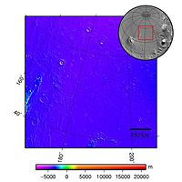
It is located northwest of the Tharsis region in the northern lowlands, spanning roughly the region 40-60° North and 150-180° West,[1][citation needed] straddling partly in the Cebrenia quadrangle (MC-07), and partly in the Diacria one (MC-02), and centered at 47°12′N 184°18′E / 47.2°N 184.3°E.[2] Arcadia marks a transition from the thinly cratered terrain to its north and the very old cratered terrain to the south. On its east it runs into the Alba Mons volcanoes. Its elevation relative to the geodetic datum varies between 0 and -3 km. [3]
In many low areas of Arcadia, there are grooves and sub-parallel ridges. These indicate movement of near surface materials and are similar to features on earth where near surface materials flow together very slowly as helped by the freezing and thawing of water located between ground layers. This supports the proposition of ground ice in the near surface of Mars in this area. This area represents an area of interest for scientists to investigate further.
Expanded craters[]
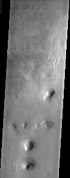
Large impacts often create swarms of small secondary craters from the debris that is blasted out as a consequence of the impact.[4] Studies of a type of secondary craters, called expanded craters, have given us insights into places where abundant ice may be present in the ground.[5] Expanded craters have lost their rims, this may be because any rim that was once present has collapsed into the crater during expansion or, lost its ice, if composed of ice.
Excess ice (ice in addition to what is in the pores of the ground) is widespread throughout the Martian mid-latitudes, especially in Arcadia Planitia. In this region, are many expanded secondary craters that probably form from impacts that destabilize a subsurface layer of excess ice, which subsequently sublimates. With sublimation the ice changes directly from a solid to gaseous form. In the impact, the excess ice is broken up, resulting in an increase in surface area. Ice will sublimate much more if there is more surface area. After the ice disappears into the atmosphere, dry soil material will collapse and cause the crater diameter to become larger.[6] Places on Mars that display expanded craters may indicate where future colonists can find water ice.

Close view of expanded craters, as seen by HiRISE. After the impact, ice left the ground and widened the crater's diameter.

Gullies[]
Martian gullies are small, incised networks of narrow channels and their associated downslope sediment deposits, found on the planet of Mars. They are named for their resemblance to terrestrial gullies. First discovered on images from Mars Global Surveyor, they occur on steep slopes, especially on the walls of craters. Usually, each gully has a dendritic alcove at its head, a fan-shaped apron at its base, and a single thread of incised channel linking the two, giving the whole gully an hourglass shape.[7] They are believed to be relatively young because they have few, if any craters. A subclass of gullies is also found cut into the faces of sand dunes which themselves considered to be quite young. On the basis of their form, aspects, positions, and location amongst and apparent interaction with features thought to be rich in water ice, many researchers believed that the processes carving the gullies involve liquid water. However, this remains a topic of active research. The pictures below show gullies in Arcadia Planitia.

MOLA map showing boundaries for part of Arcadia Planitia and other regions

Wide view of group of gullies, as seen by HiRISE under HiWish program. Note that part of this image is enlarged in the following image.

Close-up of gullies, as seen by HiRISE under HiWish program. Arrow points to streamlined features. This enlarged view shows an excellent view of polygons which are common where ice-rich ground freezes and thaws.
Arcadia Planitia


Interactive Mars map[]

See also[]
- Climate of Mars
- Geography of Mars
- List of plains on Mars
- Martian Gullies
References[]
- ^ A bit tightlier precise, from 33.9°N to 64.2°N and from 165.8°W to 210.4°W.
- ^ "Arcadia Planitia". Gazetteer of Planetary Nomenclature. USGS Astrogeology Science Center. Retrieved 2015-03-10.
- ^ R. Greeley, "Arcadia Planitia" Archived March 11, 2007, at the Wayback Machine URL accessed July 31, 2006.
- ^ http://www.uahirise.org/epo/nuggets/expanded-secondary.pdf
- ^ http://www.uahirise.org/epo/nuggets/expanded-secondary.pdf
- ^ Viola, D., et al. 2014. EXPANDED CRATERS IN ARCADIA PLANITIA: EVIDENCE FOR >20 MYR OLD SUBSURFACE ICE. Eighth International Conference on Mars (2014). 1022pdf.
- ^ Malin, M., Edgett, K. 2000. Evidence for recent groundwater seepage and surface runoff on Mars. Science 288, 2330–2335.
External links[]
| show Authority control |
|---|
- Plains on Mars
- Cebrenia quadrangle
- Diacria quadrangle