Ariège (river)
| Ariège | |
|---|---|
 The Ariège near Ax-les-Thermes | |
 | |
| Location | |
| Countries | |
| Physical characteristics | |
| Source | |
| • location | Pyrenees |
| • elevation | ± 2,400 m (7,900 ft) |
| Mouth | |
• location | Garonne |
• coordinates | 43°31′2″N 1°24′36″E / 43.51722°N 1.41000°ECoordinates: 43°31′2″N 1°24′36″E / 43.51722°N 1.41000°E |
| Length | 163 km (101 mi) |
| Basin size | 3,860 km2 (1,490 sq mi) |
| Discharge | |
| • average | 65 m3/s (2,300 cu ft/s) |
| Basin features | |
| Progression | Garonne→ Gironde estuary→ Atlantic Ocean |

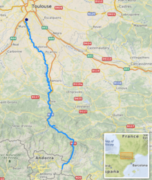
The Ariège (Occitan: Arièja, Catalan: Arieja) is a 163 km long river in southern France, right tributary of the Garonne.[1] Its source is in the Pyrenees, where it forms part of the border with Andorra. It flows north through the following towns in two departments:
- In Ariège: Ax-les-Thermes, Les Cabannes, Tarascon-sur-Ariège, Montgaillard, Foix, Varilhes, Pamiers, Saverdun.
- In Haute-Garonne: Cintegabelle, Auterive, Pinsaguel.
Its longest tributaries are the Hers-Vif and the Lèze. It flows into the Garonne in Portet-sur-Garonne, south of Toulouse.[1] Taken literally, the Latin origin of the river's name, Aurigera, indicates it to be a source of gold.
References[]
External links[]
- http://www.geoportail.fr
- History and real-time water heights of Ariege river, Garonne river, and other tributaries
| Wikimedia Commons has media related to Ariège River. |
| hide Authority control | |
|---|---|
| General | |
| National libraries | |
| Other |
|
This Occitanie geographical article is a stub. You can help Wikipedia by . |
Categories:
- Tributaries of the Garonne
- Rivers of France
- Rivers of Andorra
- International rivers of Europe
- Rivers of Ariège (department)
- Rivers of Haute-Garonne
- Andorra–France border
- Rivers of Occitanie
- Border rivers
- Occitanie geography stubs
- France river stubs
- Europe river stubs
- Andorra geography stubs