Montgaillard, Ariège
show This article may be expanded with text translated from the corresponding article in French. (December 2008) Click [show] for important translation instructions. |
Montgaillard | |
|---|---|
Commune | |
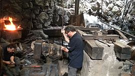 A blacksmith at Montgaillard Forge | |
show Location of Montgaillard | |
 Montgaillard | |
| Coordinates: 42°56′07″N 1°38′07″E / 42.9353°N 1.6353°ECoordinates: 42°56′07″N 1°38′07″E / 42.9353°N 1.6353°E | |
| Country | France |
| Region | Occitanie |
| Department | Ariège |
| Arrondissement | Foix |
| Canton | Foix |
| Intercommunality | CA Pays Foix-Varilhes |
| Government | |
| • Mayor (2020–2026) | Michel Caux |
| Area 1 | 7.93 km2 (3.06 sq mi) |
| Population (Jan. 2018)[1] | 1,474 |
| • Density | 190/km2 (480/sq mi) |
| Time zone | UTC+01:00 (CET) |
| • Summer (DST) | UTC+02:00 (CEST) |
| INSEE/Postal code | 09207 /09330 |
| Elevation | 394–941 m (1,293–3,087 ft) (avg. 442 m or 1,450 ft) |
| 1 French Land Register data, which excludes lakes, ponds, glaciers > 1 km2 (0.386 sq mi or 247 acres) and river estuaries. | |


Montgaillard (French pronunciation: [mɔ̃ɡajaʁ] (![]() listen); Occitan: Montgalhard) is a commune in the Ariège department in southwestern France.
listen); Occitan: Montgalhard) is a commune in the Ariège department in southwestern France.
Population[]
| Year | Pop. | ±% |
|---|---|---|
| 1962 | 1,007 | — |
| 1968 | 1,265 | +25.6% |
| 1975 | 1,434 | +13.4% |
| 1982 | 1,378 | −3.9% |
| 1990 | 1,312 | −4.8% |
| 1999 | 1,364 | +4.0% |
| 2008 | 1,341 | −1.7% |
See also[]
References[]
- ^ "Populations légales 2018". INSEE. 28 December 2020.
| Wikimedia Commons has media related to Montgaillard, Ariège. |
This Ariège geographical article is a stub. You can help Wikipedia by . |
Categories:
- Communes of Ariège (department)
- Ariège (department) geography stubs