Bordes-Uchentein
Bordes-Uchentein | |
|---|---|
Commune | |
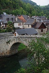 The 13th century bridge in Les Bordes-sur-Lez | |
Location of Bordes-Uchentein  | |
 Bordes-Uchentein | |
| Coordinates: 42°53′53″N 1°01′48″E / 42.898°N 1.030°ECoordinates: 42°53′53″N 1°01′48″E / 42.898°N 1.030°E | |
| Country | France |
| Region | Occitanie |
| Department | Ariège |
| Arrondissement | Saint-Girons |
| Canton | Couserans Ouest |
| Intercommunality | Couserans - Pyrénées |
| Area 1 | 54.48 km2 (21.03 sq mi) |
| Population (Jan. 2018)[1] | 186 |
| • Density | 3.4/km2 (8.8/sq mi) |
| Time zone | UTC+01:00 (CET) |
| • Summer (DST) | UTC+02:00 (CEST) |
| INSEE/Postal code | 09062 /09800 |
| 1 French Land Register data, which excludes lakes, ponds, glaciers > 1 km2 (0.386 sq mi or 247 acres) and river estuaries. | |


Bordes-Uchentein is a commune in the department of Ariège, southern France. The municipality was established on 1 January 2017 by merger of the former communes of Les Bordes-sur-Lez (the seat) and Uchentein.[2]
See also[]
References[]
| Wikimedia Commons has media related to Bordes-Uchentein. |
- ^ "Populations légales 2018". The National Institute of Statistics and Economic Studies. 28 December 2020.
- ^ Arrêté préfectoral 4 August 2016 (in French)
This Ariège geographical article is a stub. You can help Wikipedia by . |
Categories:
- Communes of Ariège (department)
- Ariège (department) geography stubs