Ercé
show This article may be expanded with text translated from the corresponding article in French. (September 2012) Click [show] for important translation instructions. |
Ercé | |
|---|---|
Commune | |
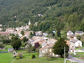 A general view of Ercé | |
show Location of Ercé | |
 Ercé | |
| Coordinates: 42°51′01″N 1°17′25″E / 42.8503°N 1.2903°ECoordinates: 42°51′01″N 1°17′25″E / 42.8503°N 1.2903°E | |
| Country | France |
| Region | Occitanie |
| Department | Ariège |
| Arrondissement | Saint-Girons |
| Canton | Couserans Est |
| Intercommunality | Couserans-Pyrénées |
| Government | |
| • Mayor (2020–2026) | Christian Carrère |
| Area 1 | 40.75 km2 (15.73 sq mi) |
| Population (Jan. 2018)[1] | 550 |
| • Density | 13/km2 (35/sq mi) |
| Time zone | UTC+01:00 (CET) |
| • Summer (DST) | UTC+02:00 (CEST) |
| INSEE/Postal code | 09113 /09140 |
| Elevation | 574–1,905 m (1,883–6,250 ft) (avg. 620 m or 2,030 ft) |
| 1 French Land Register data, which excludes lakes, ponds, glaciers > 1 km2 (0.386 sq mi or 247 acres) and river estuaries. | |


Ercé (French pronunciation: [ɛʁse]; Occitan: Èrce) is a commune in the Ariège department in southwestern France.
Population[]
Inhabitants are called Ercéens.
| Year | Pop. | ±% |
|---|---|---|
| 1962 | 1,008 | — |
| 1968 | 1,012 | +0.4% |
| 1975 | 990 | −2.2% |
| 1982 | 750 | −24.2% |
| 1990 | 566 | −24.5% |
| 1999 | 532 | −6.0% |
| 2008 | 550 | +3.4% |
See also[]
References[]
- ^ "Populations légales 2018". INSEE. 28 December 2020.
| Wikimedia Commons has media related to Ercé. |
This Ariège geographical article is a stub. You can help Wikipedia by . |
Categories:
- Communes of Ariège (department)
- Ariège (department) geography stubs