Alos, Ariège
Alos | |
|---|---|
Commune | |
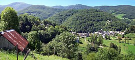 A general view of Alos | |
show Location of Alos | |
 Alos | |
| Coordinates: 42°54′33″N 1°08′45″E / 42.9092°N 1.1458°ECoordinates: 42°54′33″N 1°08′45″E / 42.9092°N 1.1458°E | |
| Country | France |
| Region | Occitanie |
| Department | Ariège |
| Arrondissement | Saint-Girons |
| Canton | Couserans Est |
| Intercommunality | |
| Government | |
| • Mayor (2020–2026) | Alain Tortet[1] |
| Area 1 | 24.26 km2 (9.37 sq mi) |
| Population (Jan. 2018)[2] | 120 |
| • Density | 4.9/km2 (13/sq mi) |
| Time zone | UTC+01:00 (CET) |
| • Summer (DST) | UTC+02:00 (CEST) |
| INSEE/Postal code | 09008 /09200 |
| Elevation | 553–1,874 m (1,814–6,148 ft) (avg. 650 m or 2,130 ft) |
| 1 French Land Register data, which excludes lakes, ponds, glaciers > 1 km2 (0.386 sq mi or 247 acres) and river estuaries. | |


Alos is a commune in the Ariège department in the Occitanie region of southwestern France.
The inhabitants of the commune are known as Alosiens or Alosiennes[3]
Geography[]
Alos is located some 100 km south by south-west of Toulouse, about 40 km west of Foix, and about 10 km north of the Spanish border. It is a high mountain commune with only three tortuous access roads: the D37 branching west from the D3 south of Lacourt enters the commune in the northeast and continues to the village before continuing south-east to join the D17 road north of Seix. There is also the D137 road coming south-west from Moulis which enters the commune in the north and joins the D37 near the village. Apart from Alos there are the hamlets of Artiguenard and La Riviere in the commune. There are numerous small country roads throughout much of the commune which consists mainly of mountain slopes and forests.[4]
The Riviere d'Alois flows out of the north-east to join the Salat river to the east. Numerous streams feed into the Alois including the Raven de Guerbrens which forms part of the eastern border and the Ruisseau de Argeniere which flows from the south of the commune. Many other streams flow into the Alois from all corners of the commune.[4]
Neighbouring communes and villages[]
| show Places adjacent to Alos, Ariège |
|---|
Administration[]
This list is incomplete; you can help by . (April 2021) |
List of Successive Mayors of Alos[5]
| From | To | Name |
|---|---|---|
| 2001 | 2014 | André Pujol |
| 2014 | 2026 | Alain Tortet |
Population[]
| Year | Pop. | ±% |
|---|---|---|
| 2004 | 121 | — |
| 2006 | 114 | −5.8% |
| 2007 | 119 | +4.4% |
| 2008 | 123 | +3.4% |
| 2009 | 128 | +4.1% |
| 2010 | 130 | +1.6% |
| 2011 | 132 | +1.5% |
| 2012 | 125 | −5.3% |
| 2013 | 119 | −4.8% |
| 2014 | 112 | −5.9% |
| 2015 | 113 | +0.9% |
| 2016 | 115 | +1.8% |
See also[]
References[]
- ^ "Répertoire national des élus: les maires". data.gouv.fr, Plateforme ouverte des données publiques françaises (in French). 2 December 2020.
- ^ "Populations légales 2018". INSEE. 28 December 2020.
- ^ Inhabitants of Ariège (in French)
- ^ Jump up to: a b c Google Maps
- ^ List of Mayors of France (in French)
External links[]
- Alos on the old National Geographic Institute website (in French)
- Alos on Lion1906
- Alos on Géoportail, National Geographic Institute (IGN) website (in French)
- Alos on the 1750 Cassini Map
| Wikimedia Commons has media related to Alos, Ariège. |
- Communes of Ariège (department)