Montoulieu, Ariège
This article may be expanded with text translated from the corresponding article in French. (December 2008) Click [show] for important translation instructions.
|
Montoulieu | |
|---|---|
Commune | |
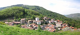 A general view of Montoulieu | |
Location of Montoulieu  | |
 Montoulieu | |
| Coordinates: 42°54′32″N 1°37′45″E / 42.9089°N 1.6292°ECoordinates: 42°54′32″N 1°37′45″E / 42.9089°N 1.6292°E | |
| Country | France |
| Region | Occitanie |
| Department | Ariège |
| Arrondissement | Foix |
| Canton | Sabarthès |
| Intercommunality | CA Pays Foix-Varilhes |
| Government | |
| • Mayor (2020–2026) | Éric Donzé |
| Area 1 | 14.12 km2 (5.45 sq mi) |
| Population (Jan. 2018)[1] | 407 |
| • Density | 29/km2 (75/sq mi) |
| Time zone | UTC+01:00 (CET) |
| • Summer (DST) | UTC+02:00 (CEST) |
| INSEE/Postal code | 09210 /09000 |
| Elevation | 428–1,488 m (1,404–4,882 ft) (avg. 400 m or 1,300 ft) |
| 1 French Land Register data, which excludes lakes, ponds, glaciers > 1 km2 (0.386 sq mi or 247 acres) and river estuaries. | |


Montoulieu (French pronunciation: [mɔ̃tuljø]; Occitan: Montoliu) is a commune in the Ariège department in southwestern France.
Population[]
| Year | Pop. | ±% |
|---|---|---|
| 1962 | 239 | — |
| 1968 | 398 | +66.5% |
| 1975 | 202 | −49.2% |
| 1982 | 220 | +8.9% |
| 1990 | 278 | +26.4% |
| 1999 | 305 | +9.7% |
| 2008 | 364 | +19.3% |
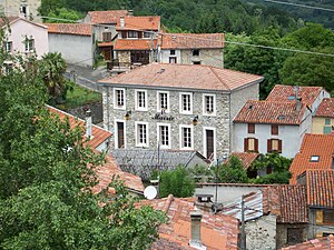
Town hall
See also[]
References[]
- ^ "Populations légales 2018". The National Institute of Statistics and Economic Studies. 28 December 2020.
| Wikimedia Commons has media related to Montoulieu (Ariège). |
This Ariège geographical article is a stub. You can help Wikipedia by . |
Categories:
- Communes of Ariège (department)
- Ariège (department) geography stubs