Antras, Ariège
Antras | |
|---|---|
Commune | |
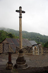 The Marble Cross in the village square | |
show Location of Antras | |
 Antras | |
| Coordinates: 42°52′57″N 0°56′38″E / 42.8825°N 0.9439°ECoordinates: 42°52′57″N 0°56′38″E / 42.8825°N 0.9439°E | |
| Country | France |
| Region | Occitanie |
| Department | Ariège |
| Arrondissement | Saint-Girons |
| Canton | Couserans Ouest |
| Intercommunality | |
| Government | |
| • Mayor (2020–2026) | Marc Woiry[1] |
| Area 1 | 20.02 km2 (7.73 sq mi) |
| Population (Jan. 2018)[2] | 68 |
| • Density | 3.4/km2 (8.8/sq mi) |
| Time zone | UTC+01:00 (CET) |
| • Summer (DST) | UTC+02:00 (CEST) |
| INSEE/Postal code | 09011 /09800 |
| Elevation | 777–2,268 m (2,549–7,441 ft) (avg. 900 m or 3,000 ft) |
| 1 French Land Register data, which excludes lakes, ponds, glaciers > 1 km2 (0.386 sq mi or 247 acres) and river estuaries. | |


Antras (Antràs in Occitan) is a commune in the Ariège department in the Occitanie region of southwestern France.
The inhabitants of the commune are known as Antrasois or Antrasoises.[3]
Geography[]
Antras is located some 25 km south-east of Saint-Gaudens, 20 km north-east of Bagneres-de-Luchon, and only 1 km from the Spanish border. It was part of the former province of Couserans in the Biros Valley. No district roads or highways pass through the commune and the only access to the village is by a mountain road (the Route d'Antras) from the D4 road at Sentein. There are few roads in the commune with some mountain tracks and unformed roads. The commune is mountainous and heavily forested.[4]
The Ruisseau d'Antras flows from the commune down to Sentein where it joins the Lez which continues to Saint-Girons where it joins the Salat river.[4]
Neighbouring communes and villages[]
| show Places adjacent to Antras, Ariège |
|---|
Administration[]
This list is incomplete; you can help by . (April 2021) |
List of Successive Mayors of Antras[5]
| From | To | Name |
|---|---|---|
| 2001 | 2008 | Aimé Cep |
| 2008 | 2026 | Marc Woiry |
Population[]
| Year | Pop. | ±% |
|---|---|---|
| 2005 | 64 | — |
| 2006 | 67 | +4.7% |
| 2007 | 73 | +9.0% |
| 2008 | 71 | −2.7% |
| 2009 | 67 | −5.6% |
| 2010 | 62 | −7.5% |
| 2011 | 61 | −1.6% |
| 2012 | 58 | −4.9% |
| 2013 | 58 | +0.0% |
| 2014 | 61 | +5.2% |
| 2015 | 64 | +4.9% |
| 2016 | 65 | +1.6% |
Sites and Monuments[]
- A Marble Cross (1785)
 is registered as an historical monument.[6]
 - A Romanesque Parish Church. The church contains several items that are registered as historical objects:
See also[]
External links[]
- Antras on the old National Geographic Institute website (in French)
- Antras on Lion1906
- Antras on Géoportail, National Geographic Institute (IGN) website (in French)
- Antras on the 1750 Cassini Map
References[]
- ^ "Répertoire national des élus: les maires". data.gouv.fr, Plateforme ouverte des données publiques françaises (in French). 2 December 2020.
- ^ "Populations légales 2018". INSEE. 28 December 2020.
- ^ Inhabitants of Ariège (in French)
- ^ Jump up to: a b c Google Maps
- ^ List of Mayors of France (in French)
- ^ Ministry of Culture, Mérimée PA00093767 Marble Cross (in French)
- ^ Ministry of Culture, Palissy PM09000009 6 Candlesticks (in French)

- ^ Ministry of Culture, Palissy PM09000008 Altar, Retable, Tabernacle, Altar dais, a Painting, and 2 Statues (in French)
- ^ Ministry of Culture, Palissy PM09000007 Sculpture: Chrisme (in French)
- ^ Ministry of Culture, Palissy PM09000006 Chalice with Paten (in French)
- ^ Ministry of Culture, Palissy PM09000005 Ampulla of Saint Chrême (in French)
- ^ Ministry of Culture, Palissy PM09000004 Statue: Virgin and child (in French)
| Wikimedia Commons has media related to Antras (Ariège). |
- Communes of Ariège (department)