Saint-Michel, Ariège
This article may be expanded with text translated from the corresponding article in French. (December 2008) Click [show] for important translation instructions.
|
Saint-Michel | |
|---|---|
Commune | |
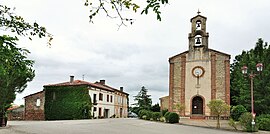 The church and surroundings in Saint-Michel | |
Location of Saint-Michel  | |
 Saint-Michel | |
| Coordinates: 43°08′10″N 1°30′11″E / 43.1361°N 1.5031°ECoordinates: 43°08′10″N 1°30′11″E / 43.1361°N 1.5031°E | |
| Country | France |
| Region | Occitanie |
| Department | Ariège |
| Arrondissement | Pamiers |
| Canton | Pamiers-1 |
| Government | |
| • Mayor (2020–2026) | Sandrine Eychenne[1] |
| Area 1 | 5.92 km2 (2.29 sq mi) |
| Population (Jan. 2018)[2] | 77 |
| • Density | 13/km2 (34/sq mi) |
| Time zone | UTC+01:00 (CET) |
| • Summer (DST) | UTC+02:00 (CEST) |
| INSEE/Postal code | 09271 /09100 |
| Elevation | 310–434 m (1,017–1,424 ft) (avg. 400 m or 1,300 ft) |
| 1 French Land Register data, which excludes lakes, ponds, glaciers > 1 km2 (0.386 sq mi or 247 acres) and river estuaries. | |


Saint-Michel (French pronunciation: [sɛ̃ miʃɛl] (![]() listen); Languedocien: Sent Miquèl) is a commune in the Ariège department in southwestern France.
listen); Languedocien: Sent Miquèl) is a commune in the Ariège department in southwestern France.
Population[]
Inhabitants of Saint-Michel are called Saint-Micheliens.
| Year | Pop. | ±% |
|---|---|---|
| 1962 | 82 | — |
| 1968 | 90 | +9.8% |
| 1975 | 74 | −17.8% |
| 1982 | 74 | +0.0% |
| 1990 | 80 | +8.1% |
| 1999 | 68 | −15.0% |
| 2008 | 80 | +17.6% |
See also[]
References[]
- ^ "Répertoire national des élus: les maires". data.gouv.fr, Plateforme ouverte des données publiques françaises (in French). 9 August 2021.
- ^ "Populations légales 2018". The National Institute of Statistics and Economic Studies. 28 December 2020.
| Wikimedia Commons has media related to Saint-Michel, Ariège. |
This Ariège geographical article is a stub. You can help Wikipedia by . |
Categories:
- Communes of Ariège (department)
- Ariège (department) geography stubs