Gourbit
This article may be expanded with text translated from the corresponding article in French. (December 2008) Click [show] for important translation instructions.
|
Gourbit | |
|---|---|
Commune | |
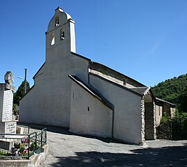 The church in Gourbit | |
Location of Gourbit  | |
 Gourbit | |
| Coordinates: 42°50′41″N 1°32′01″E / 42.8447°N 1.5336°ECoordinates: 42°50′41″N 1°32′01″E / 42.8447°N 1.5336°E | |
| Country | France |
| Region | Occitanie |
| Department | Ariège |
| Arrondissement | Foix |
| Canton | Sabarthès |
| Intercommunality | Pays de Tarascon |
| Government | |
| • Mayor (2020–2026) | Bernard Deffarges[1] |
| Area 1 | 17.95 km2 (6.93 sq mi) |
| Population (Jan. 2018)[2] | 74 |
| • Density | 4.1/km2 (11/sq mi) |
| Time zone | UTC+01:00 (CET) |
| • Summer (DST) | UTC+02:00 (CEST) |
| INSEE/Postal code | 09136 /09400 |
| Elevation | 671–2,162 m (2,201–7,093 ft) (avg. 800 m or 2,600 ft) |
| 1 French Land Register data, which excludes lakes, ponds, glaciers > 1 km2 (0.386 sq mi or 247 acres) and river estuaries. | |


Gourbit is a commune in the Ariège department in southwestern France.
Population[]
| Year | Pop. | ±% |
|---|---|---|
| 1962 | 42 | — |
| 1968 | 71 | +69.0% |
| 1975 | 87 | +22.5% |
| 1982 | 82 | −5.7% |
| 1990 | 69 | −15.9% |
| 1999 | 61 | −11.6% |
| 2008 | 92 | +50.8% |
See also[]
References[]
- ^ "Répertoire national des élus: les maires". data.gouv.fr, Plateforme ouverte des données publiques françaises (in French). 9 August 2021.
- ^ "Populations légales 2018". The National Institute of Statistics and Economic Studies. 28 December 2020.
| Wikimedia Commons has media related to Gourbit. |
This Ariège geographical article is a stub. You can help Wikipedia by . |
Categories:
- Communes of Ariège (department)
- Ariège (department) geography stubs