Les Pujols
This article may be expanded with text translated from the corresponding article in French. (December 2008) Click [show] for important translation instructions.
|
Les Pujols | |
|---|---|
Commune | |
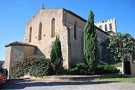 The church in Les Pujols | |
 Coat of arms | |
Location of Les Pujols  | |
 Les Pujols | |
| Coordinates: 43°05′21″N 1°43′10″E / 43.0892°N 1.7194°ECoordinates: 43°05′21″N 1°43′10″E / 43.0892°N 1.7194°E | |
| Country | France |
| Region | Occitanie |
| Department | Ariège |
| Arrondissement | Pamiers |
| Canton | Pamiers-2 |
| Government | |
| • Mayor (2020–2026) | Jérôme Blasquez |
| Area 1 | 13.18 km2 (5.09 sq mi) |
| Population (Jan. 2018)[1] | 816 |
| • Density | 62/km2 (160/sq mi) |
| Time zone | UTC+01:00 (CET) |
| • Summer (DST) | UTC+02:00 (CEST) |
| INSEE/Postal code | 09238 /09100 |
| Elevation | 255–384 m (837–1,260 ft) (avg. 335 m or 1,099 ft) |
| 1 French Land Register data, which excludes lakes, ponds, glaciers > 1 km2 (0.386 sq mi or 247 acres) and river estuaries. | |


Les Pujols (French pronunciation: [le pyʒɔl]; Occitan: Les Pujòls) is a commune in the Ariège department in southwestern France.
Population[]
The Inhabitants are known as Pujolais.
| Year | Pop. | ±% |
|---|---|---|
| 1962 | 385 | — |
| 1968 | 387 | +0.5% |
| 1975 | 375 | −3.1% |
| 1982 | 417 | +11.2% |
| 1990 | 470 | +12.7% |
| 1999 | 521 | +10.9% |
| 2006 | 635 | +21.9% |
| 2007 | 651 | +2.5% |
| 2008 | 656 | +0.8% |
| 2012 | 740 | +12.8% |
| 2015 | 775 | +4.7% |
| 2017 | 805 | +3.9% |
| 2018 | 816 | +1.4% |
See also[]
References[]
- ^ "Populations légales 2018". The National Institute of Statistics and Economic Studies. 28 December 2020.
| Wikimedia Commons has media related to Les Pujols. |
This Ariège geographical article is a stub. You can help Wikipedia by . |
Categories:
- Communes of Ariège (department)
- Ariège (department) geography stubs