Le Carlaret
This article may be expanded with text translated from the corresponding article in French. (December 2008) Click [show] for important translation instructions.
|
Le Carlaret | |
|---|---|
Commune | |
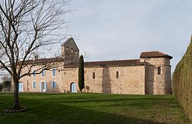 The church in Le Carlaret | |
Location of Le Carlaret  | |
 Le Carlaret | |
| Coordinates: 43°08′30″N 1°41′46″E / 43.1417°N 1.6961°ECoordinates: 43°08′30″N 1°41′46″E / 43.1417°N 1.6961°E | |
| Country | France |
| Region | Occitanie |
| Department | Ariège |
| Arrondissement | Pamiers |
| Canton | Pamiers-2 |
| Government | |
| • Mayor (2020–2026) | Jean-Marc Soula[1] |
| Area 1 | 9.39 km2 (3.63 sq mi) |
| Population (Jan. 2018)[2] | 274 |
| • Density | 29/km2 (76/sq mi) |
| Time zone | UTC+01:00 (CET) |
| • Summer (DST) | UTC+02:00 (CEST) |
| INSEE/Postal code | 09081 /09100 |
| Elevation | 250–327 m (820–1,073 ft) (avg. 289 m or 948 ft) |
| 1 French Land Register data, which excludes lakes, ponds, glaciers > 1 km2 (0.386 sq mi or 247 acres) and river estuaries. | |


Le Carlaret (French pronunciation: [lə kaʁlaʁɛ]) is a commune in the Ariège department in southwestern France.
Population[]
Its inhabitants are called Carlaretois.
| Year | Pop. | ±% |
|---|---|---|
| 1962 | 106 | — |
| 1968 | 135 | +27.4% |
| 1975 | 154 | +14.1% |
| 1982 | 149 | −3.2% |
| 1990 | 142 | −4.7% |
| 1999 | 141 | −0.7% |
| 2008 | 209 | +48.2% |
See also[]
References[]
- ^ "Répertoire national des élus: les maires". data.gouv.fr, Plateforme ouverte des données publiques françaises (in French). 9 August 2021.
- ^ "Populations légales 2018". The National Institute of Statistics and Economic Studies. 28 December 2020.
| Wikimedia Commons has media related to Le Carlaret. |
This Ariège geographical article is a stub. You can help Wikipedia by . |
Categories:
- Communes of Ariège (department)
- Ariège (department) geography stubs