Aston, Ariège
Aston | |
|---|---|
Commune | |
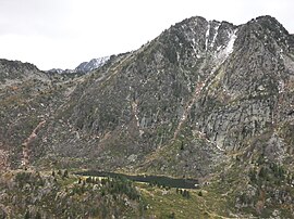 View of the Étang de Larnoum one of many Étangs in the commune | |
show Location of Aston | |
 Aston | |
| Coordinates: 42°46′32″N 1°40′27″E / 42.7756°N 1.6742°ECoordinates: 42°46′32″N 1°40′27″E / 42.7756°N 1.6742°E | |
| Country | France |
| Region | Occitanie |
| Department | Ariège |
| Arrondissement | Foix |
| Canton | Haute-Ariège |
| Intercommunality | |
| Government | |
| • Mayor (2020–2026) | Alain Pujol[1] |
| Area 1 | 153.8 km2 (59.4 sq mi) |
| Population (Jan. 2018)[2] | 214 |
| • Density | 1.4/km2 (3.6/sq mi) |
| Time zone | UTC+01:00 (CET) |
| • Summer (DST) | UTC+02:00 (CEST) |
| INSEE/Postal code | 09024 /09310 |
| Elevation | 554–2,912 m (1,818–9,554 ft) (avg. 560 m or 1,840 ft) |
| 1 French Land Register data, which excludes lakes, ponds, glaciers > 1 km2 (0.386 sq mi or 247 acres) and river estuaries. | |


Aston is a commune in the Ariège department in the Occitanie region of south-western France.
The inhabitants of the commune are known as Astonnais or Astonnaises.[3]
Geography[]
Aston is located some 90 km west of Perpignan and 30 km south of Foix. It is located high in the Pyrenees with its southern border the border between France and Andorra. Access to the commune is solely by a local road from Les Cabannes in the north to the village which lies at the northern tip of the commune. The D522 road from Les Cabannes passes down the eastern border of the commune in a tortuous route which terminates at the Angaka ski resort just east of the commune. Except for a very small area around the village the commune is extremely rugged and heavily forested.[4]
The Aston river rises in the south of the commune and flows north, passing through the village, to join the Ariège at Les Cabannes, gathering a very large number of tributaries from all corners of the commune.[4]
Neighbouring communes and villages[]
| show Places adjacent to Aston, Ariège |
|---|
Administration[]
This list is incomplete; you can help by . (April 2021) |
List of Successive Mayors[6]
| From | To | Name |
|---|---|---|
| 2001 | 2020 | Jean Lasalle |
| 2020 | 2026 | Alain Pujol |
Demography[]
In 2017 the commune had 220 inhabitants.
|
| |||||||||||||||||||||||||||||||||||||||||||||||||||||||||||||||||||||||||||||||||||||||||||||||||||||||||||||||
| Source: EHESS[7] and INSEE[8] | ||||||||||||||||||||||||||||||||||||||||||||||||||||||||||||||||||||||||||||||||||||||||||||||||||||||||||||||||
Economy[]
The commune has two dams for the generation of Hydroelectricity: the Laparan and the Riète. They are operated by Électricité de France.

Sites and monuments[]
- The Étang de Larnoum
See also[]
References[]
- ^ "Répertoire national des élus: les maires". data.gouv.fr, Plateforme ouverte des données publiques françaises (in French). 2 December 2020.
- ^ "Populations légales 2018". INSEE. 28 December 2020.
- ^ Inhabitants of Ariège (in French)
- ^ Jump up to: a b Google Maps
- ^ Géoportail, IGN (in French)
- ^ List of Mayors of France (in French)
- ^ Des villages de Cassini aux communes d'aujourd'hui: Commune data sheet Aston, EHESS. (in French)
- ^ Population en historique depuis 1968, INSEE
External links[]
- Aston on Géoportail, National Geographic Institute (IGN) website (in French)
- Aston on the 1750 Cassini Map
| Wikimedia Commons has media related to Aston (Ariège). |
- Communes of Ariège (department)