Roumengoux
show This article may be expanded with text translated from the corresponding article in French. (December 2008) Click [show] for important translation instructions. |
Roumengoux | |
|---|---|
Commune | |
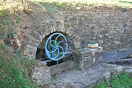 The fountain in Roumengoux | |
show Location of Roumengoux | |
 Roumengoux | |
| Coordinates: 43°04′21″N 1°56′06″E / 43.0725°N 1.935°ECoordinates: 43°04′21″N 1°56′06″E / 43.0725°N 1.935°E | |
| Country | France |
| Region | Occitanie |
| Department | Ariège |
| Arrondissement | Pamiers |
| Canton | Mirepoix |
| Intercommunality | Pays de Mirepoix |
| Government | |
| • Mayor (2008–2014) | Rolland Sanchez |
| Area 1 | 6.87 km2 (2.65 sq mi) |
| Population (Jan. 2018)[1] | 160 |
| • Density | 23/km2 (60/sq mi) |
| Time zone | UTC+01:00 (CET) |
| • Summer (DST) | UTC+02:00 (CEST) |
| INSEE/Postal code | 09251 /09500 |
| Elevation | 304–461 m (997–1,512 ft) (avg. 319 m or 1,047 ft) |
| 1 French Land Register data, which excludes lakes, ponds, glaciers > 1 km2 (0.386 sq mi or 247 acres) and river estuaries. | |


Roumengoux is a commune in the Ariège department in southwestern France.
Population[]
Inhabitants of Roumengoux are called Roumengosiens.
| Year | Pop. | ±% |
|---|---|---|
| 1962 | 97 | — |
| 1968 | 121 | +24.7% |
| 1975 | 78 | −35.5% |
| 1982 | 116 | +48.7% |
| 1990 | 115 | −0.9% |
| 1999 | 127 | +10.4% |
| 2008 | 147 | +15.7% |
See also[]
References[]
- ^ "Populations légales 2018". INSEE. 28 December 2020.
| Wikimedia Commons has media related to Roumengoux. |
| Authority control |
|
|---|
This Ariège geographical article is a stub. You can help Wikipedia by . |
Categories:
- Communes of Ariège (department)
- Ariège (department) geography stubs