Dun, Ariège
This article may be expanded with text translated from the corresponding article in French. (December 2008) Click [show] for important translation instructions.
|
Dun | |
|---|---|
Commune | |
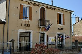 School and town hall | |
 Coat of arms | |
Location of Dun  | |
 Dun | |
| Coordinates: 43°01′42″N 1°47′59″E / 43.0283°N 1.7997°ECoordinates: 43°01′42″N 1°47′59″E / 43.0283°N 1.7997°E | |
| Country | France |
| Region | Occitanie |
| Department | Ariège |
| Arrondissement | Pamiers |
| Canton | Mirepoix |
| Intercommunality | Pays de Mirepoix |
| Government | |
| • Mayor (2020–2026) | Florent Pauly[1] |
| Area 1 | 41.41 km2 (15.99 sq mi) |
| Population (Jan. 2018)[2] | 611 |
| • Density | 15/km2 (38/sq mi) |
| Time zone | UTC+01:00 (CET) |
| • Summer (DST) | UTC+02:00 (CEST) |
| INSEE/Postal code | 09122 /09000 |
| Elevation | 303–648 m (994–2,126 ft) (avg. 331 m or 1,086 ft) |
| 1 French Land Register data, which excludes lakes, ponds, glaciers > 1 km2 (0.386 sq mi or 247 acres) and river estuaries. | |


Dun is a commune in the Ariège department in the Occitanie region in southwestern France. In 1973, the commune Dun was expanded with the former communes Merviel, Engraviès and Senesse-de-Senabugue.[3]
Population[]
| Year | Pop. | ±% |
|---|---|---|
| 1962 | 459 | — |
| 1968 | 429 | −6.5% |
| 1975 | 394 | −8.2% |
| 1982 | 401 | +1.8% |
| 1990 | 394 | −1.7% |
| 1999 | 491 | +24.6% |
| 2008 | 3,942 | +702.9% |
See also[]
References[]
- ^ "Répertoire national des élus: les maires". data.gouv.fr, Plateforme ouverte des données publiques françaises (in French). 9 August 2021.
- ^ "Populations légales 2018". The National Institute of Statistics and Economic Studies. 28 December 2020.
- ^ INSEE
| Wikimedia Commons has media related to Dun (Ariège). |
This Ariège geographical article is a stub. You can help Wikipedia by . |
Categories:
- Communes of Ariège (department)
- Ariège (department) geography stubs