Cintegabelle
Cintegabelle
Senta Gabèla (Occitan) | |
|---|---|
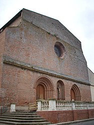 The church in Cintegabelle | |
 Coat of arms | |
show Location of Cintegabelle | |
 Cintegabelle | |
| Coordinates: 43°18′49″N 1°31′53″E / 43.3136°N 1.5314°ECoordinates: 43°18′49″N 1°31′53″E / 43.3136°N 1.5314°E | |
| Country | France |
| Region | Occitanie |
| Department | Haute-Garonne |
| Arrondissement | Muret |
| Canton | Auterive |
| Government | |
| • Mayor (2020–2026) | Sébastien Vincini |
| Area 1 | 52.92 km2 (20.43 sq mi) |
| Population (Jan. 2018)[1] | 2,909 |
| • Density | 55/km2 (140/sq mi) |
| Time zone | UTC+01:00 (CET) |
| • Summer (DST) | UTC+02:00 (CEST) |
| INSEE/Postal code | 31145 /31550 |
| Elevation | 185–302 m (607–991 ft) (avg. 247 m or 810 ft) |
| 1 French Land Register data, which excludes lakes, ponds, glaciers > 1 km2 (0.386 sq mi or 247 acres) and river estuaries. | |


Cintegabelle (French pronunciation: [sɛ̃tɡabɛl]; Occitan: Senta Gabèla) is a commune in the Haute-Garonne department in southwestern France.
Population[]
| Year | Pop. | ±% |
|---|---|---|
| 1962 | 1,796 | — |
| 1968 | 1,818 | +1.2% |
| 1975 | 1,921 | +5.7% |
| 1982 | 2,061 | +7.3% |
| 1990 | 2,215 | +7.5% |
| 1999 | 2,341 | +5.7% |
| 2004 | 2,483 | +6.1% |
| 2008 | 2,577 | +3.8% |
| 2009 | 2,618 | +1.6% |
| 2014 | 2,840 | +8.5% |
| 2015 | 2,875 | +1.2% |
| 2018 | 2,909 | +1.2% |
The inhabitants of the commune are called Cintegabellois
Transport[]
- Cintegabelle station, on the line from Toulouse to Foix and Latour-de-Carol.
See also[]
References[]
- ^ "Populations légales 2018". INSEE. 28 December 2020.
| Wikimedia Commons has media related to Cintegabelle. |
| show Authority control |
|---|
This Haute-Garonne geographical article is a stub. You can help Wikipedia by . |
Categories:
- Communes of Haute-Garonne
- Haute-Garonne geography stubs