Arish
El-Arish
العريش ϩⲣⲓⲛⲟⲕⲟⲣⲟⲩⲣⲁ | |
|---|---|
City | |
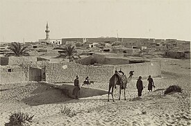 Skyline of Arish, 1916 | |
 Flag | |
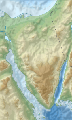 El-Arish Location within the Sinai Peninsula | |
| Coordinates: 31°07′55″N 33°48′12″E / 31.132072°N 33.803376°ECoordinates: 31°07′55″N 33°48′12″E / 31.132072°N 33.803376°E | |
| Country | |
| Governorate | North Sinai |
| Elevation | 32 m (105 ft) |
| Population (2012) | |
| • Total | 164,830 |
| Time zone | UTC+2 (EET) |
| Area code(s) | (+20) 68 |


ʻArish or el-ʻArīsh (Arabic: العريش al-ʿArīš Egyptian Arabic pronunciation: [elʕæˈɾiːʃ], Coptic: ϩⲣⲓⲛⲟⲕⲟⲣⲟⲩⲣⲁ Hrinokorura) is the capital and largest city (with 164,830 inhabitants as of 2012) of the North Sinai Governorate of Egypt, as well as the largest city on the entire Sinai Peninsula, lying on the Mediterranean coast 344 kilometers (214 mi) northeast of Cairo. It borders the Gaza Strip and Israel.
ʻArīsh is distinguished by its clear blue water, widespread fruitful palmy wood on its coast, and its soft white sand. It has a marina, and many luxury hotels. The city also has some of the faculties of Suez Canal University.
ʻArīsh is by a big wadi, the Wādī al-ʻArīsh, which receives flash flood water from much of north and central Sinai. The Azzaraniq Protectorate is on the eastern side of ʻArīsh.[1]
History[]


The city grew around a Bedouin settlement near the ancient Ptolemaic outpost of Rhinocorura (in Greek "the place where noses (of criminals) are cut off").[2] In the Middle Ages, pilgrims misidentified [ no evidence for this claim ] the site as the Sukkot of the Bible. ʻArīsh means "palm huts" in Modern Standard Arabic. M. Ignace de Rossi derived the Arabic name from the Egyptian ϫⲟⲣϣⲁ(ⲓ) Jorsha, "noseless", an analogue of Greek Rhinocorura.[3]
New fortifications were constructed at the original site by the Ottoman Empire in 1560. During the Napoleonic Wars, the French laid siege to the fort, which fell after 11 days on February 19, 1799. During World War I, the fort was destroyed by British bombers. It was later the location of the 45th Stationary Hospital which treated casualties of the Palestine campaign. The remains of those who died there were later moved to Kantara Cemetery.
Theodor Herzl, the founder of Zionism, proposed ʻArīsh as a Jewish homeland since neither the Sultan nor the Kaiser supported settlement in Palestine. In 1903, Joseph Chamberlain, the British colonial secretary, agreed to consider ʻArīsh, and Herzl commissioned the lawyer David Lloyd George a charter draft, but his application was turned down once an expedition, led by Leopold Kessler had returned and submitted a detailed report to Herzl, which outlined a proposal to divert some of the Nile waters to the area for the purpose of settlement.[4]
El-ʻArīsh Military Cemetery was built in 1919 marked the dead of World War I. It was designed by Robert Lorimer.[5]
On December 8, 1958, an air battle occurred between Egyptian and Israeli air forces over ʻArīsh.[6]
ʻArīsh was under military occupation by Israel briefly in 1956 and again from 1967 to 1979. It was returned to Egypt in 1979 after the signing of the Egypt–Israel Peace Treaty.
In the Sinai mosque attack of 24 November 2017, 305 people were killed in a bomb and gun attack at the mosque in Bir al-Abd in al-Rawda, North Sinai near ʻArīsh.[7][8]
On 9 February 2021 six locals were killed by IS militants.[9]
Geography[]
Arish is in the northern Sinai and is about 50 kilometres (31 mi) from the Rafah Border Crossing with the Gaza Strip.[10]
Arish is the closest larger settlement to Lake Bardawil.
Transport[]
The city is served by el Arish International Airport. The construction of the northern coast highway in Egypt (North Sinai part) was expected to be finished by 2008 linking El-Qantarah at the Suez Canal in the west to the Gaza Strip border passing by Arish. The railway line from Cairo is also under re-construction and it recently reached the "Ser and Qawarir zone" west of Arish. This route was formerly part of the Palestine Railways built during World War I and World War II to connect Egypt with Turkey. The railway was cut during the formation of Israel. The North Sinai is a milestone for the Egyptian government planners to redistribute the high-density population in the Nile Delta, and it is expected that by accomplishing the transportation and irrigation projects, three million Egyptians will settle in North Sinai.[citation needed]
Climate[]
Its Köppen climate classification is hot desert (BWh), although prevailing Mediterranean winds moderate its temperatures, typical to the rest of the northern coast of Egypt.
The highest record temperature was 45 °C (113 °F), recorded on May 29, 2003, while the lowest record temperature was −6 °C (21 °F), recorded on January 8, 1994.[11]
| hideClimate data for Arish | |||||||||||||
|---|---|---|---|---|---|---|---|---|---|---|---|---|---|
| Month | Jan | Feb | Mar | Apr | May | Jun | Jul | Aug | Sep | Oct | Nov | Dec | Year |
| Record high °C (°F) | 30.5 (86.9) |
31.7 (89.1) |
38.1 (100.6) |
41.0 (105.8) |
44.2 (111.6) |
45.0 (113.0) |
38.8 (101.8) |
36.4 (97.5) |
39.2 (102.6) |
38.4 (101.1) |
36.0 (96.8) |
32.6 (90.7) |
45.0 (113.0) |
| Average high °C (°F) | 18.8 (65.8) |
19.3 (66.7) |
21.3 (70.3) |
25.4 (77.7) |
27.6 (81.7) |
30.4 (86.7) |
31.6 (88.9) |
29.3 (84.7) |
30.2 (86.4) |
28.2 (82.8) |
24.8 (76.6) |
20.5 (68.9) |
25.6 (78.1) |
| Daily mean °C (°F) | 12.6 (54.7) |
13.1 (55.6) |
15.0 (59.0) |
18.4 (65.1) |
21.0 (69.8) |
24.3 (75.7) |
26.0 (78.8) |
26.2 (79.2) |
24.4 (75.9) |
21.8 (71.2) |
17.7 (63.9) |
13.9 (57.0) |
19.5 (67.1) |
| Average low °C (°F) | 7.6 (45.7) |
7.9 (46.2) |
9.3 (48.7) |
12.1 (53.8) |
14.5 (58.1) |
17.8 (64.0) |
20.2 (68.4) |
19.1 (66.4) |
19.3 (66.7) |
16.3 (61.3) |
12.0 (53.6) |
8.9 (48.0) |
13.7 (56.7) |
| Record low °C (°F) | 1.6 (34.9) |
0.9 (33.6) |
2.0 (35.6) |
5.6 (42.1) |
8.2 (46.8) |
10.9 (51.6) |
16.3 (61.3) |
19.5 (67.1) |
15.1 (59.2) |
11.0 (51.8) |
1.7 (35.1) |
3.0 (37.4) |
0.9 (33.6) |
| Average precipitation mm (inches) | 28 (1.1) |
16 (0.6) |
13 (0.5) |
11 (0.4) |
1 (0.0) |
0 (0) |
0 (0) |
0 (0) |
0 (0) |
6 (0.2) |
9 (0.4) |
22 (0.9) |
106 (4.2) |
| Average precipitation days (≥ 1.0 mm) | 1.7 | 1.2 | 1.0 | 0.3 | 0.1 | 0.0 | 0.0 | 0.0 | 0.0 | 0.3 | 0.5 | 1.0 | 6.1 |
| Average relative humidity (%) | 71 | 70 | 71 | 67 | 68 | 68 | 70 | 71 | 73 | 72 | 70 | 72 | 70 |
| Source 1: NOAA[12] | |||||||||||||
| Source 2: Climate Charts[13] | |||||||||||||
See also[]
- List of cities and towns in Egypt
- Sinai and Palestine Campaign
References[]
- ^ Arish. Britannica.com
- ^ Meer, Michaël N. van der. "The Natural and Geographical Context of the Septuagint: Some Preliminary Observations". Published in: W. Kraus, M. Karrer, M. Sigismund (eds.), Die Septuaginta. Entstehung, Sprache, Geschichte. 3. Internationale Fachtagung veranstaltet von Septuaginta Deutsch (LXX.D), Wuppertal 22.-25. Juli 2010 (WUNT I 286; Tübingen; Mohr-Siebeck, 2012), pp. 387-421.
- ^ M. Ignace de Rossi. Etymologiae aegyptiacae. pp. 16–17.
- ^ Jerusalem: The Biography, page 380–381, Simon Sebag Montefiore, Weidenfeld & Nicolson, 2011. ISBN 978-0-297-85265-0
- ^ Dictionary of Scottish Architects: Robert Lorimer
- ^ until return
- ^ "Egypt mosque attack kills at least 184". BBC News. 2017-11-24. Retrieved 2017-11-24.
- ^ "Egypt mosque attack: Death toll rises to 235, state media says". Retrieved 24 November 2017.
- ^ "Officials: IS militants kill 6 Bedouins in Egypt's Sinai". Yahoo. Retrieved 2021-02-09.
- ^ "Palestinian airline resumes flights." Agence France-Presse with the Khaleej Times. 10 May 2012. Retrieved on 10 May 2012.
- ^ "Al Arish, Egypt". Voodoo Skies. 13 August 2013. Archived from the original on 12 October 2014. Retrieved 13 August 2013.
- ^ "El Arish Climate Normals 1961–1990". National Oceanic and Atmospheric Administration. Retrieved June 25, 2015.
- ^ "El Arish, Egypt: Climate, Global Warming, and Daylight Charts and Data". Climate Charts. Retrieved 8 July 2013.
| Wikimedia Commons has media related to Arish. |
| show |
|---|
| Authority control |
|---|
- Cities in Egypt
- Governorate capitals in Egypt
- Populated coastal places in Egypt
- Populated places in North Sinai Governorate
- Tourism in Egypt
- Ports and harbours of the Arab League
- Transport in the Arab League