Esna
This article needs additional citations for verification. (January 2014) |
Esna
إسنا | |
|---|---|
City | |
  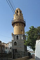   Clockwise from top: Corniech of Old Esna, inside Khnum Temple, Minaret of Esna Mosque, Esna new Locks, Farmlands near Esna | |
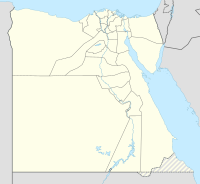 Esna Location in Egypt | |
| Coordinates: 25°18′N 32°33′E / 25.300°N 32.550°E | |
| Country | |
| Governorate | Luxor |
| Time zone | UTC+2 (EST) |

Esna (Arabic: إسنا IPA: [ˈʔesnæ], Ancient Egyptian: jwny.t or tꜣ-snt;[1][2] Coptic: ⲥⲛⲏ or ⲉⲥⲛⲏ Snē from tꜣ-snt;[3] Koinē Greek: Λατόπολις Latópolis[4] or πόλις Λάτων (Pólis Látōn)[5] or Λάττων (Lattōn);[6][7] Latin: Lato), is a city of Egypt. It is located on the west bank of the Nile some 55 km south of Luxor. The town was formerly part of the modern Qena Governorate, but as of 9 December 2009, it was incorporated into the new Luxor Governorate.
Latopolis[]
| ||||
| jwnj(t)[8] | ||||
|---|---|---|---|---|
| Era: New Kingdom (1550–1069 BC) | ||||
| Egyptian hieroglyphs |
| |||
| snj(t)[9][10] | |||
|---|---|---|---|
| Era: Late Period (664–332 BC) | |||
| Egyptian hieroglyphs |
This city of Latopolis (πόλις Λάτων) in the Thebaid of Upper Egypt should not be confused with the more northerly city of Letopolis (Λητοῦς Πόλις), ancient Khem, modern Ausim, in the Nile Delta in Lower Egypt.[11][12][13]
Ancient city[]


The name "Latopolis" is in honor of the Nile perch, Lates niloticus, the largest of the 52 species which inhabit the Nile,[14] which was abundant in these stretches of the river in ancient times, and which appears in sculptures, among the symbols of the goddess Neith, associated by the ancient Greeks as Pallas-Athene, surrounded by the oval shield or ring indicative of royalty or divinity.[15] Held sacred, the Lates niloticus was buried in a cemetery west of the town.
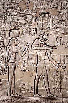
The temple of Esna, dedicated to the god Khnum, his consorts Menhit and Nebtu, their son, Heka, and the goddess Neith,[16] was remarkable for the beauty of its site and the magnificence of its architecture. It was built of red sandstone, and its portico consisted of six rows of four columns each, with lotus-leaf capitals, all of which however differ from each other.[17] The temple contains very late hieroglyphic inscription, dating from the reign of Decius (249–251 AD).[18]
Another temple of the same period has been identified at Kom Mer, about 12 km to the south, but cannot be excavated because a modern village is built over it.
There was a smaller temple, dedicated to the triad of Latopolis, about two miles and a half north of the city, at a village now called el-Dayr. Here, too, is a small zodiac of the age of Ptolemy III Euergetes (246–221 BC). This latter building was destroyed in the 19th century, as it stood in the way of a new canal. The temple of Esna was cleared of the soil and rubbish which filled its area when Vivant Denon visited it, and served as a cotton warehouse in the mid-19th century.[19]
With the exception of the jamb of a gateway—now converted into a door-sill—of the reign of Thutmose II (Eighteenth Dynasty), the remains of Latopolis belong to the Ptolemaic or Roman eras. Ptolemy III Euergetes, the restorer of so many temples in Upper Egypt, was a benefactor to Latopolis, and he is depicted upon the walls of its temple followed by a tame lion, and in the act of striking down the chiefs of his enemies. The name of Ptolemy V Epiphanes is found also inscribed upon a doorway. Although the scale of the ruins are impressive, their sculptures and hieroglyphics attest to the decline of Egyptian art. The west wall features reliefs of Ptolemy VI Philometor and Ptolemy VIII Physcon. The pronaos, which alone exists, resembles in style that of Apollonopolis Magna (Edfu), and was begun not earlier than the reign of Claudius (41–54 AD), and completed in that of Vespasian, whose name and titles are carved on the dedicatory inscription over the entrance. On the ceiling of the pronaos is the larger Latopolitan Zodiac. The name of the emperor Geta, the last ruler that can be read in hieroglyphics, although partially erased by his brother and murderer Caracalla (212), is still legible on the walls of Latopolis. Before raising their own edifice, the Romans seem to have destroyed even the basements of the earlier Egyptian temple. The ceremonial way, which probably linked the quay to the temple, has disappeared. The quay bears cartouches of Marcus Aurelius.
The cemetery west of the town, where the Lates niloticus was buried, also contains human burials dating of the Middle Kingdom to the Late Period.
Ritual significance[]

The Temple of Esna conveys a sense of the importance which the Ancient Egyptians placed upon their places of worship. All Egyptians who entered the confines of an Egyptian temple were required "to comply with the strict rules regarding ritual purity."[20] According to inscriptions carved on the walls of the Temple of Esna, those who entered this temple were expected to fastidiously cut their fingernails and toenails, remove other body hair, wash their hands with natron (a natural occurring salt), "be dressed in linen (they were forbidden from wearing wool), and not to have had sexual intercourse for several days."[21]
Medieval Heritage City
Esna enjoys a rich intangible heritage in terms of its unique social structure where the city center is subdivided into spatial domains inhabited by deeply-rooted Esna families, and its traditional crafts – all on the verge of extinction as a life heritage extended since the medieval eras.[22] forms of this life heritage is the presence other monuments and buildings of historic significance in Esna from various eras like Wekalet El Geddawy a caravanserai from the ottoman era, was established in the 18th century by the Ottoman Ruler by Hassan El-Geddawy (Ruler of Geddah -KSA) and it was named after him, it represents one of three caravanserais in south of Egypt, and it is the only one that still maintains its unique original design. The Wekala was one of the most important trade centers in South of Egypt in the 18th century with traders from all over Africa coming through the west desert and the red sea, and It now stands as a testament to the strength of trade and the strategic position of Esna as a trade center in the south of Egypt at the time. The building was historically used for the sale of slaves, animals, crops and crafts. The historic market is one of a few still standing markets in the south of Egypt and gets its significance from being a local historic market that portrays Esna’s authentic local life. Products sold in the market include home supplies, local crafts and bridal needs. El-Amry Minaret is the only remaining part of the historic mosque with the same name which was torn down and rebuilt in the 1960s in a modern style. The Mosque was established between the years 474 & 476 AD on the Islamic Calendar by Badr El Deen Gamaly and it was the first to be built in Esna in the Fatimid Era. The oil press has belonged to the family of Bakour for over 200 years and it is the only still standing oil press in Esna. Martyrs’ Monastery It was established in the 6th century.[23] The Monastery is of a great significance for Christians since it was established in the age of Christine persecution in Egypt by Saint Helena after a battle between the Romans and Coptic Egyptians which lead to the death of 3600 Martyrs. The battle was led by the roman emperor Diocletian who started an attack against Christians in Egypt. On the day of the Martyrs’ Massacre, an attack was started that caused the Bishop of the city of Esna “Father Ammonius” to flee with the whole Christian population to the monastery to hide there from the troops of the emperor however they were later found there and killed. The monastery is visited by thousands of Egyptians from all over the country every year due to its significant value.[24]
Al-Qīsāriyya Market
Like any other function that needs a space or built environment, trade, caused the existence of several types of buildings and public open spaces to help facilitate its process in Esna. Historically, the public open space located between Khnum Temple and al-`Amriyya Minaret functioned as Esna's main square – where various historic photos of Esna depicts this area as the city's main marketplace. Wakālat al-Jiddāwī (caravanserai), one of the city's main trading buildings existed on this square as well. And to the north and south of the square, al-Qīsāriyya Street extended -parallel to the Nile River- for a distance of almost 1.5 km. The street is named after Esna's renowned al-Qīsāriyya Market.[25] Qīsāriyyas are an urban market typology that is believed to have existed since the Roman times; possibly since the age of the Roman emperor Augustus Caesar (63 B.C. – 14 A.D.) They consist of a long and narrow covered street, and sometimes a network of streets, that exist in the heart of a city. The street is surrounded by 2-3 story buildings on both sides; where shops and workshops are located on the ground floor – directly opening to the street. The upper floors include living quarters – sometimes for traders visiting the city. Wakālas (caravanserais), exist along- or close to this street. Such street markets are famous for traditional goods such as textiles, spices, traditional clothing, etc. Qīsāriyyas exist in many Upper Egyptian cities such as Asyūt, Sūhaj, Qenā and Esna; and they are all functioning until today as popular local markets.[23][26] Al-Qīsāriyya Market in Esna is one of the city's main attractions, not only for tourists but to a greater extent, for residents of Esna and its surrounding villages. Until today, it plays a regional trade function as the hub for many commercial activities. It includes different trades and goods such as textiles, clothing, houseware, haberdashery, tailoring, upholstery, etc. Hence, it is a major destination for families preparing for marriage and newly-married brides. Esna's Qīsāriyya Market consists of two main parts. The northern part starts from Wakālat al-Jiddāwī, passing by the Church of Mother Dūlāji, and heading northward. This part is buzzing with life and local atmosphere as local residents and villagers wander there for shopping activities. This part gets busier in its northern edge, covered with modern sharing elements, since is close to Esna's public transportation hub. Along this part of the street, many architecturally significant buildings -dating back to the turn of the twentieth century- exist. It also includes, tucked in a small alleyway, the significant façade of Bayt al-Shabrāwī, built in 1874 with its intricate decorative fired brick and woodwork. On Saturday's, the northern part of al-Qīsāriyya is even more lively since it merges with Esna's weekly Saturday Market – famous for its local gastronomic and clay tableware products. On the other hand, the southern part starts directly from the south of Khnum Temple, heading southward. This part is quieter, but it is the most unique part of the market at all since it still maintains its traditional wooden cover and is surrounded by mud brick buildings that maintain their traditional features, such as their colorful wooden doors, until today.[27] This covered part of the market extends for a distance of almost 130 m (425 feet) and is located on the route from the Khnum Temple area to many of Esna's attractions such as the traditional Bakkūr Oil Press, the Church of the Blessed Virgin Mary and many of the city's architecturally significant buildings. More than 120 local shops exist in this part and they mostly encompass traditional tailors (tailoring traditional dresses such as Jalābiyyas) and sell textiles – including women traditional textiles and shawls indigenous to Esna such as al-Ḥabra, al-Farkha and al-Nishra. This southern part of al-Qīsāriyya Market still includes the remains of a traditional wakāla- accessed through one of the textile shops. The market's traditional wooden cover in addition to its direction from north to south provides a flow of cool breeze that makes shopping and wandering there a pleasant experience, especially on a hot summer day.[28]
Modern Esna[]


Two barrage bridges straddle the Nile at this point: one built by the British in 1906, and the "Electricity Bridge" built in the 1990s. Navigation, particularly Nile cruisers ferrying tourists from Luxor to Aswan 155 km further upstream, can be held up for hours while vessels negotiate their way through the lock system.
The two main points of interest in Esna are its lively tourist-oriented market, which fills a couple of streets leading inland from the corniche. The other is the temple of Esna. The temple, which has only been partially excavated, is about 200 meters from the river and some 9 meters below street level.
- 2017 attack
Attackers on a patrol killed a policeman and a civilian, and wounded three other victims.[29]
Former bishopric[]
Under the older name of "Latopolis," the city is now a Roman Catholic Latin titular see. It is sometimes confused with the titular Diocese of Letopolis in modern Ausim, a suffragan of Hermopolis Parva.[30]
Climate[]
Köppen-Geiger climate classification system classifies its climate as hot desert climate (BWh).
| hideClimate data for Esna | |||||||||||||
|---|---|---|---|---|---|---|---|---|---|---|---|---|---|
| Month | Jan | Feb | Mar | Apr | May | Jun | Jul | Aug | Sep | Oct | Nov | Dec | Year |
| Average high °C (°F) | 23.4 (74.1) |
25.5 (77.9) |
29.5 (85.1) |
34.8 (94.6) |
39.2 (102.6) |
40.8 (105.4) |
40.9 (105.6) |
41 (106) |
38.4 (101.1) |
35.7 (96.3) |
30.3 (86.5) |
25.2 (77.4) |
33.7 (92.7) |
| Daily mean °C (°F) | 14.9 (58.8) |
16.5 (61.7) |
20.2 (68.4) |
25.3 (77.5) |
29.9 (85.8) |
31.6 (88.9) |
32.1 (89.8) |
32.3 (90.1) |
30 (86) |
27.1 (80.8) |
21.6 (70.9) |
16.7 (62.1) |
24.8 (76.7) |
| Average low °C (°F) | 6.4 (43.5) |
7.5 (45.5) |
11 (52) |
15.9 (60.6) |
20.6 (69.1) |
22.5 (72.5) |
23.4 (74.1) |
23.6 (74.5) |
21.6 (70.9) |
18.6 (65.5) |
12.9 (55.2) |
8.3 (46.9) |
16.0 (60.9) |
| Average precipitation mm (inches) | 0 (0) |
0 (0) |
0 (0) |
0 (0) |
0 (0) |
0 (0) |
0 (0) |
0 (0) |
0 (0) |
0 (0) |
0 (0) |
0 (0) |
0 (0) |
| Source: Climate-Data.org[31] | |||||||||||||
See also[]
Notes[]
- ^ Richter, Barbara A. (2016-04-15). The Theology of Hathor of Dendera: Aural and Visual Scribal Techniques in the Per-Wer Sanctuary. ISD LLC. ISBN 9781937040529.
- ^ Kaper, Olaf E. (2003). The Egyptian God Tutu: A Study of the Sphinx-god and Master of Demons with a Corpus of Monuments. Peeters Publishers. ISBN 9789042912175.
- ^ Werner Vycichl, Dictionnaire étymologique de la langue copte (Louvain, 1983)
- ^ Strabo xvii. pp. 812, 817
- ^ Ptol. iv. 5. § 71
- ^ Hierocl. p. 732
- ^ Itin. Antonin. p. 160
- ^ Gauthier, Henri (1925). Dictionnaire des Noms Géographiques Contenus dans les Textes Hiéroglyphiques Vol. 1. p. 54.
- ^ Wallis Budge, E. A. (1920). An Egyptian hieroglyphic dictionary: with an index of English words, king list and geological list with indexes, list of hieroglyphic characters, coptic and semitic alphabets, etc. Vol II. John Murray. p. 1031.
- ^ Gauthier, Henri (1928). Dictionnaire des Noms Géographiques Contenus dans les Textes Hiéroglyphiques Vol. 5. p. 38.
- ^ "Trismegistos". www.trismegistos.org. Retrieved 2018-02-24.
- ^ "Egypt: Minor Temple and Other Ruins of the Nile Delta, Part I". www.touregypt.net (in Russian). Retrieved 2018-02-24.
- ^ Margaret Bunson, Encyclopaedia of Ancient Egypt (Infobase Publishing 2009 ISBN 978-1-43810997-8), p. 60
- ^ Russegger, Reisen, vol. I. p.300
- ^ Wilkinson, M. and C. vol. V. p.253
- ^ Kathryn A. Bard (editor), Encyclopedia of the Archaeology of Ancient Egypt (1999), p. 295.
- ^ Dominique-Vivant Denon, Voyage dans la Basse et lau Haute Égypte, vol. I. (1818), p.148.
- ^ Chisholm, Hugh, ed. (1911). . Encyclopædia Britannica. 9 (11th ed.). Cambridge University Press. p. 771.
- ^ Karl Richard Lepsius, Nubische Grammatik mit einer Einleitung über die Völker und Sprachen Afrika's. Berlin: Verlag von Wilhelm Hertz (1880), p.63
- ^ Lucia Gahlin, Egypt: Gods, Myths and Religion, Anness Publishing Litd (Lorenz Books) 2001. p.106
- ^ Gahlin, p.106
- ^ Ibrahim, Kareem (April 6, 2014). "Post-Revolutionary Urban Egypt: A New Mode of Practice?". Égypte/Monde arabe (11): 237–266. doi:10.4000/ema.3330 – via journals.openedition.org.
- ^ Jump up to: a b Powell, E. T. (2012). Tell this in My Memory: Stories of Enslavement from Egypt. Sudan and the Ottoman Empire (Vol. 67). California: Stanford University Press.
- ^ Gabra, Gawdat; Takla, Hany N. (February 2, 2010). Christianity and Monasticism in Upper Egypt. American Univ in Cairo Press. ISBN 9789774163111 – via Google Books.
- ^ Nūr, H. M. (1995). Madynat Esnā w āṯhārhā f āl-oʿṣowr āl-islāmyah. Cairo: Dār āl-mʿārf.
- ^ Shaw, S. J. (1964). Ottoman Egypt in the Age of the French Revolution by Hụsayn Afandi (Vol. 11). Cambridge: Harvard University Press.
- ^ Wākid, ʻ. a.-L., & Marʻī., H. (1957). Wāhāt Misṛ: Juzur al-Raḥma w Jannāt al-Saḥaṛāʼ. Cairo: Maktabat al-Anjlū al-Misṛīyah.
- ^ Zahrān, D. M.-K. (2011). Al-ʻImāra al-Islāmiyya: Dirāsa Fī ʻImārat al-Munshaʼāt al-Tijāriyya Fī al-Qarn al-Tāsiʻ ʻAshar al-Mīlādī. al-Qāhira: Dār al-Kitāb al-Ḥadīth
- ^ "Two killed, three wounded in Egypt attack near Luxor". english.alarabiya.net. Retrieved 2018-02-24.
- ^ Worp, K. A. (1994). "A Checklist of Bishops in Byzantine Egypt". Zeitschrift für Papyrologie und Epigraphik. 100: 283–318.
- ^ "Climate: Isna - Climate graph, Temperature graph, Climate table". Climate-Data.org. Retrieved 18 August 2013.
References[]
 This article incorporates text from a publication now in the public domain: Smith, William, ed. (1854–1857). Dictionary of Greek and Roman Geography. London: John Murray. Missing or empty
 |title=(help)
External links[]
| Wikimedia Commons has media related to Esna. |
| Wikisource has the text of the 1911 Encyclopædia Britannica article Esna. |
- Esna II - An Evolving Translation, Ongoing translation of hieroglyphic inscriptions from Esna temple
- biologie.uni-hamburg.de, Gallery of temple reliefs
- Falling Rain Genomics, Inc. Geographical information on Esna
- (in German) Esna on Wikivoyage
- fotopedia.com, Selected photos of Esna
- Esna revisited, Al-ahram Weekly historical review on Esna by Giovanna Montalbetti with photos
| show |
|---|
| show Authority control |
|---|
- Ancient Greek archaeological sites in Egypt
- Archaeological sites in Egypt
- Egyptian temples
- Populated places in Qena Governorate
- Roman sites in Egypt
- Former populated places in Egypt
- Khnum