Arrondissement of Saint-Flour
Saint-Flour | |
|---|---|
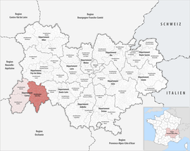 Location within the region Auvergne-Rhône-Alpes | |
| Country | France |
| Region | Auvergne-Rhône-Alpes |
| Department | Cantal |
| No. of communes | 98 |
| Subprefecture | Saint-Flour |
| Area | 2,510.6 km2 (969.3 sq mi) |
| Population (Jan. 2018)[1] | 37,351 |
| • Density | 15/km2 (40/sq mi) |
| INSEE code | 153 |
The arrondissement of Saint-Flour is an arrondissement of France in the Cantal department in the Auvergne-Rhône-Alpes region. It has 98 communes.[2] Its population is 37,697 (2016), and its area is 2,510.6 km2 (969.3 sq mi).[3]
Composition[]
The communes of the arrondissement of Saint-Flour, and their INSEE codes, are:[2]
- Albepierre-Bredons (15025)
- Allanche (15001)
- Alleuze (15002)
- Andelat (15004)
- Anglards-de-Saint-Flour (15005)
- Anterrieux (15007)
- Auriac-l'Église (15013)
- Bonnac (15022)
- Brezons (15026)
- Celoux (15032)
- Cézens (15033)
- Chaliers (15034)
- Chanterelle (15040)
- La Chapelle-d'Alagnon (15041)
- La Chapelle-Laurent (15042)
- Charmensac (15043)
- Chaudes-Aigues (15045)
- Chazelles (15048)
- Cheylade (15049)
- Le Claux (15050)
- Clavières (15051)
- Coltines (15053)
- Condat (15054)
- Coren (15055)
- Cussac (15059)
- Deux-Verges (15060)
- Dienne (15061)
- Espinasse (15065)
- Ferrières-Saint-Mary (15069)
- Fridefont (15073)
- Gourdièges (15077)
- Jabrun (15078)
- Joursac (15080)
- Lacapelle-Barrès (15086)
- Landeyrat (15091)
- Lastic (15097)
- Laurie (15098)
- Laveissenet (15100)
- Laveissière (15101)
- Lavigerie (15102)
- Leyvaux (15105)
- Lieutadès (15106)
- Lorcières (15107)
- Lugarde (15110)
- Malbo (15112)
- Marcenat (15114)
- Marchastel (15116)
- Massiac (15119)
- Maurines (15121)
- Mentières (15125)
- Molèdes (15126)
- Molompize (15127)
- Montboudif (15129)
- Montchamp (15130)
- Montgreleix (15132)
- Murat (15138)
- Narnhac (15139)
- Neussargues en Pinatelle (15141)
- Neuvéglise-sur-Truyère (15142)
- Paulhac (15148)
- Paulhenc (15149)
- Peyrusse (15151)
- Pierrefort (15152)
- Pradiers (15155)
- Rageade (15158)
- Rézentières (15161)
- Roffiac (15164)
- Ruynes-en-Margeride (15168)
- Saint-Amandin (15170)
- Saint-Bonnet-de-Condat (15173)
- Sainte-Marie (15198)
- Saint-Flour (15187)
- Saint-Georges (15188)
- Saint-Martial (15199)
- Saint-Martin-sous-Vigouroux (15201)
- Saint-Mary-le-Plain (15203)
- Saint-Poncy (15207)
- Saint-Rémy-de-Chaudes-Aigues (15209)
- Saint-Saturnin (15213)
- Saint-Urcize (15216)
- Ségur-les-Villas (15225)
- Soulages (15229)
- Talizat (15231)
- Tanavelle (15232)
- Les Ternes (15235)
- Tiviers (15237)
- La Trinitat (15241)
- Ussel (15244)
- Vabres (15245)
- Val-d'Arcomie (15108)
- Valjouze (15247)
- Valuéjols (15248)
- Védrines-Saint-Loup (15251)
- Vernols (15253)
- Vèze (15256)
- Vieillespesse (15259)
- Villedieu (15262)
- Virargues (15263)
History[]
The arrondissement of Saint-Flour was created in 1800.[4]
As a result of the reorganisation of the cantons of France which came into effect in 2015, the borders of the cantons are no longer related to the borders of the arrondissements. The cantons of the arrondissement of Saint-Flour were, as of January 2015:[5]
- Allanche
- Chaudes-Aigues
- Condat
- Massiac
- Murat
- Pierrefort
- Ruynes-en-Margeride
- Saint-Flour-Nord
- Saint-Flour-Sud
References[]
- ^ "Téléchargement du fichier d'ensemble des populations légales en 2018". INSEE. 28 December 2020.
- ^ Jump up to: a b "Arrondissement de Saint-Flour (153)". INSEE. Retrieved 2019-09-27.
- ^ "Comparateur de territoire, géographie au 01/01/2019". INSEE. Retrieved 2019-09-27.
- ^ Historique du Cantal
- ^ "Populations légales 2012" (PDF). INSEE. December 2014. Retrieved 2019-10-08.

Categories:
- Arrondissements of Cantal