Arundel, Quebec
Arundel | |
|---|---|
Township municipality | |
 | |
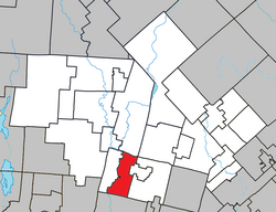 Location within Les Laurentides RCM. | |
 Arundel Location in central Quebec. | |
| Coordinates: 45°58′N 74°37′W / 45.967°N 74.617°WCoordinates: 45°58′N 74°37′W / 45.967°N 74.617°W[1] | |
| Country | |
| Province | |
| Region | Laurentides |
| RCM | Les Laurentides |
| Settled | 1854 |
| Constituted | January 1, 1878 |
| Government | |
| • Mayor | Pascale Blais |
| • Federal riding | Laurentides—Labelle |
| • Prov. riding | Argenteuil |
| Area | |
| • Total | 66.90 km2 (25.83 sq mi) |
| • Land | 65.09 km2 (25.13 sq mi) |
| Population (2011)[3] | |
| • Total | 604 |
| • Density | 9.3/km2 (24/sq mi) |
| • Pop 2006-2011 | |
| • Dwellings | 400 |
| Demonym(s) | Arundelite |
| Time zone | UTC−5 (EST) |
| • Summer (DST) | UTC−4 (EDT) |
| Postal code(s) | J0T 1A0 |
| Area code(s) | 819 |
| Highways | |

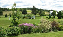
Arundel is a township municipality in Quebec, Canada, located 18 kilometres (11 mi) south of Mont Tremblant.
Arundel was settled by Scottish and Irish immigrants in the mid-19th century who established subsistence farming operations and worked the forests in winter.
Today most of the land is reserved for agricultural use despite strong growth in the region. Much of Arundel borders the Rouge River.
Demographics[]
Population trend:[4]
- Population in 2011: 604 (2006 to 2011 population change: 0.5%)
- Population in 2006: 601
- Population in 2001: 555
- Population in 1996: 533
- Population in 1991: 555
Private dwellings occupied by usual residents: 290 (total dwellings: 400)
Mother tongue:
- French as first language: 44%
- English as first language: 54%
- Other as first language: 2%
Education[]
Sir Wilfrid Laurier School Board is the English-language school board of the town. Schools serving the town:
- Arundel Elementary School[5]
- Sainte Agathe Academy (for high school only) in Sainte-Agathe-des-Monts[6]
References[]
- ^ Reference number 2234 of the Commission de toponymie du Québec (in French)
- ^ a b Geographic code 78060 in the official Répertoire des municipalités (in French)
- ^ a b "(Code 2478060) Census Profile". 2011 census. Statistics Canada. 2012.
- ^ Statistics Canada: 1996, 2001, 2006, 2011 census
- ^ "Arundel Elementary Zone." Sir Wilfrid Laurier School Board. Retrieved on September 16, 2017.
- ^ "SAINTE AGATHE HIGH SCOOL ZONE" [sic]. Sir Wilfrid Laurier School Board. Retrieved on September 17, 2017 - See text description of boundaries in: About Us" as well as the Elementary zone map - Note that all areas covered in the elementary map are also covered in the secondary one.
External links[]
- Canton Arundel Website
- Tweedsmuir Village History
- Laurentian regional website
- Historic Knox Church
- Rouge River Valley
Places adjacent to Arundel, Quebec | ||||||||||||||||
|---|---|---|---|---|---|---|---|---|---|---|---|---|---|---|---|---|
| ||||||||||||||||
| Cities/towns | |
|---|---|
| Municipalities | |
| Townships | |
| Parishes | |
| Villages | |
| |
Categories:
- Township municipalities in Quebec
- Incorporated places in Laurentides