Mirabel, Quebec
Mirabel | |
|---|---|
City | |
| Ville de Mirabel | |
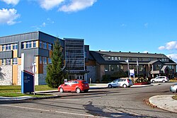 City hall of Mirabel | |
 Location with surrounding municipalities | |
 Mirabel Location in central Quebec | |
| Coordinates: 45°39′N 074°05′W / 45.650°N 74.083°WCoordinates: 45°39′N 074°05′W / 45.650°N 74.083°W[1] | |
| Country | Canada |
| Province | Quebec |
| Region | Laurentides |
| RCM | None |
| Constituted | January 1, 1971 |
| Government | |
| • Mayor | Jean Bouchard |
| • Federal riding | Mirabel |
| • Prov. riding | Mirabel |
| Area | |
| • Total | 486.80 km2 (187.95 sq mi) |
| • Land | 485.07 km2 (187.29 sq mi) |
| Population (2016)[4] | |
| • Total | 50,513 |
| • Density | 104.1/km2 (270/sq mi) |
| • Change 2011-2016 | |
| • Dwellings | 19,631 |
| Time zone | UTC−5 (EST) |
| • Summer (DST) | UTC−4 (EDT) |
| Postal code(s) | J7J, J7N |
| Area code(s) | 450 and 579 |
| Highways | |
| Website | ville |

Mirabel is an off-island suburb of Montreal, located in southern Quebec.
Mirabel is also the name of a territory equivalent to a regional county municipality (TE) and census division (CD) of Quebec, coextensive with the city of Mirabel.[3] Its geographical code is 74. Prior to 2002, Mirabel was not only a city but also comprised the Mirabel Regional County Municipality.
The city is home to Montréal-Mirabel International Airport.
History[]

Mirabel was formed through the expropriation of private lands and the merger of 8 municipalities in 1971. The former municipalities were (with their individual founding dates in brackets): Saint-Augustin (1855); Saint-Benoît (1855); Saint-Hermas (1855); Saint-Janvier-de-Blainville (1855); Sainte-Scholastique (1855); Saint-Canut (1857); Sainte-Monique (1872), and Saint-Janvier-de-la-Croix (1959). Initially called Ville de Sainte-Scholastique but renamed Mirabel in 1973, the city was planned to become a vast transportation and industrial hub for Eastern Canada with Montréal-Mirabel International Airport at its centre.[5]
The airport, which opened in 1975, never became a major aviation hub and the industrial parks never materialized, and in 2004 the airport closed to all passenger traffic.
In 2000, about 10 square kilometres (4 square miles) of Mirabel's territory was annexed by Lachute.
Communities[]
- La Belle-Rivière
- La Chapelle
- Mirabel-en-Haut
- Petit St-Charles
- Saint-Augustin
- Saint-Benoît
- Saint-Canut
- Sainte-Monique
- Saint-Hermas
- Saint-Janvier
- Saint-Jérusalem-d'Argenteuil
- Sainte-Scholastique

St-Benoit

St-Monique
St-Scholastique


Demographics[]
Population[]
| hideCanada census – Mirabel, Quebec community profile | |||
|---|---|---|---|
| 2011 | 2006 | ||
| Population: | 41,957 (+21.2% from 2006) | 34,626 (+26.8% from 2001) | |
| Land area: | 485.59 km2 (187.49 sq mi) | 485.51 km2 (187.46 sq mi) | |
| Population density: | 86.4/km2 (224/sq mi) | 71.3/km2 (185/sq mi) | |
| Median age: | 35.0 (M: 35.1, F: 34.8) | 34.3 (M: 34.6, F: 33.9) | |
| Total private dwellings: | 16,374 | 13,161 | |
| Median household income: | $67,023 | $59,981 | |
| References: 2011[3] 2006[6] earlier[7] | |||
|
|
Language[]
| Canada Census Mother Tongue - Mirabel, Quebec[8] | ||||||||||||||||||
|---|---|---|---|---|---|---|---|---|---|---|---|---|---|---|---|---|---|---|
| Census | Total | French
|
English
|
French & English
|
Other
| |||||||||||||
| Year | Responses | Count | Trend | Pop % | Count | Trend | Pop % | Count | Trend | Pop % | Count | Trend | Pop % | |||||
2016
|
50,513
|
47,560 | 94,27% | 1,050 | 2.08% | 345 | 0.68% | 1,315 | 2.6% | |||||||||
2011
|
41,810
|
40,050 | 95.79% | 820 | 1.96% | 240 | 0.57% | 700 | 1.67% | |||||||||
2006
|
34,475
|
33,185 | 96.26% | 510 | 1.48% | 180 | 0.52% | 600 | 1.74% | |||||||||
2001
|
27,115
|
26,060 | 96.11% | 460 | 1.70% | 155 | 0.57% | 440 | 1.62% | |||||||||
1996
|
22,465
|
21,605 | n/a | 96.17% | 450 | n/a | 2.00% | 145 | n/a | 0.65% | 265 | n/a | 1.18% | |||||
Climate[]
| showClimate data for Mirabel (Montréal–Mirabel International Airport) 1981−2010 |
|---|
Economy[]
Bombardier Aerospace produces CRJ700, CRJ900 & CRJ1000 regional jetliners and Airbus A220 (formerly Bombardier CSeries) at the Montreal-Mirabel International Airport. Bell Helicopters also has its major manufacturing and final assembly plant at the airport.
HydroSerre Mirabel has its headquarters in the town.
Education[]
Commission scolaire de la Seigneurie-des-Mille-Iles[]
The Commission scolaire de la Seigneurie-des-Mille-Iles (CSSMI), which operates Francophone public schools, serves the following parts of Mirabel: Saint-Augustin, Saint-Benoît, Sainte-Scholastique and a portion of Domaine-Vert.[11]
- École primaire de la Clé-des-Champs[12]
- École primaire des Blés-Dorés[13]
- École primaire Girouard[14]
- École primaire Prés fleuris[15]
- École primaire Sainte-Scholastique[16]
Other elementary schools serving sections of CCSMI Mirabel: Notre-Dame-de-l'Assomption in Blainville and Terre-Soleil in Sainte-Thérèse. Secondary schools serving sections of CSSMI Mirabel: d'Oka in Oka, in Saint-Eustache, in Blainville, in Boisbriand, and in Sainte-Thérèse.[17]
Commission scolaire de la Rivière-du-Nord[]
The Commission scolaire de la Rivière-du-Nord (CSRDN) operates Francophone public schools in other parts of Mirabel. They include:
- Secondary schools:[18]
- École secondaire de Mirabel (ESM)
- Other secondary schools serving CSRDN sections include in Lachute and , , Polyvalente Saint-Jérôme, and in Saint-Jérôme
- Primary schools:[19]
- du Parchemin
- à l'Unisson
- aux Quatre-Vents
- de la Croisée-des-Champs
- Mer-et-Monde
- Saint-Anne
- Saint-Hermas
- Other primary schools serving CSRDN Mirabel include Dubois, de l'Horizon-Soleil, Prévost, Saint-Jean-Baptiste, and Sainte-Thérèse-de-l'Enfant-Jésus in Saint-Jérôme and Jean-Moreau in Sainte-Sophie.
Sir Wilfrid Laurier School Board[]
The Sir Wilfrid Laurier School Board operates Anglophone public schools in the area around Mirabel.
Secondary schools serving portions of Mirabel include:
- Lake of Two Mountains High School in Deux-Montagnes serves southern Mirabel[20][21]
- Laurentian Regional High School in Lachute serves northern Mirabel[22]
- Rosemere High School in Rosemère serves southeast Mirabel[23]
Primary schools serving portions of Mirabel include:
- Laurentia Elementary School in Saint-Jérôme serves northern Mirabel[24]
- Mountainview Elementary School and Saint Jude Elementary School in Deux-Montagnes serve southern mirabel[25][26]
- Pierre Elliot Trudeau Elementary School in Blainville serves southeast Mirabel[27]
Sister cities[]
- Châlons-en-Champagne (France)[citation needed]
See also[]
- List of regional county municipalities and equivalent territories in Quebec
- Mirabel Aerospace Centre
- Saint Pierre River (Mirabel), a river
- Rivière aux Chiens (rivière des Mille Îles), a river
References[]
- ^ Reference number 72473 of the Commission de toponymie du Québec (in French)
- ^ Jump up to: a b Geographic code 74005 in the official Répertoire des municipalités (in French)
- ^ Jump up to: a b c "2011 Community Profiles". 2011 Canadian Census. Statistics Canada. July 5, 2013. Retrieved 2014-04-12.
- ^ "Census Profile, 2016 Census: Mirabel, Ville [Census subdivision], Quebec". Statistics Canada. Retrieved November 26, 2019.
- ^ "Mirabel (ville)" (in French). Commission de toponymie du Québec. Archived from the original on 2016-03-03. Retrieved 2009-03-10.
- ^ "2006 Community Profiles". 2006 Canadian Census. Statistics Canada. March 30, 2011. Retrieved 2014-04-12.
- ^ "2001 Community Profiles". 2001 Canadian Census. Statistics Canada. February 17, 2012.
- ^ Jump up to: a b Statistics Canada: 1996, 2001, 2006, 2011, 2016 census
- ^ http://www.mamrot.gouv.qc.ca/repertoire-des-municipalites/fiche/municipalite/74005/
- ^ "Montréal–Mirabel International Airport]". Canadian Climate Normals 1981−2010. Retrieved 2016-05-12.
- ^ "Admission et inscription Archived 2015-01-31 at the Wayback Machine." Commission scolaire de la Seigneurie-des-Mille-Iles. Retrieved on December 7, 2014. "La Commission scolaire de la Seigneurie-des-Mille-Iles (CSSMI) offre ses services aux résidents des municipalités de : Blainville, Boisbriand, Bois-des-Filion, Deux-Montagnes, Lorraine, Mirabel (Saint-Augustin, Saint-Benoît, Sainte-Scholastique et secteur du Domaine-Vert), Oka, Pointe-Calumet, Rosemère, Sainte-Anne-des-Plaines, Sainte-Marthe-sur-le-Lac, Sainte-Thérèse, Saint-Eustache, Saint-Joseph-du-Lac, Saint-Placide et Terrebonne Ouest."
- ^ "Accueil." École primaire de la Clé-des-Champs. Retrieved on December 8, 2014.
- ^ "des Blés-Dorés." Commission scolaire de la Seigneurie-des-Mille-Iles. Retrieved on September 20, 2017.
- ^ "Girouard." Commission scolaire de la Seigneurie-des-Mille-Iles. Retrieved on December 8, 2014.
- ^ "Prés fleuris." Commission scolaire de la Seigneurie-des-Mille-Iles. Retrieved on December 8, 2014.
- ^ "Sainte-Scholastique." Commission scolaire de la Seigneurie-des-Mille-Iles. Retrieved on December 8, 2014.
- ^ "Répertoire des aires de desserte par ville 2017 - 2018 (Généré le 1/9/2017) Ville Mirabel Archived 2017-09-20 at the Wayback Machine." Commission scolaire de la Seigneurie-des-Mille-Iles. Retrieved on September 20, 2017.
- ^ "Trouver une école ou un centre." Commission scolaire de la Rivière-du-Nord. Retrieved on September 24, 2017. For attendance boundary information, click "Par bassin d'école"
- ^ "Préscolaire / primaire." Commission scolaire de la Rivière-du-Nord. Retrieved on December 7, 2014.
- ^ "Overview." Lake of Two Mountains High School. Retrieved on December 8, 2014.
- ^ "LAKE OF TWO MOUNTAINS HS ZONE." Sir Wilfrid Laurier School Board. Retrieved on September 4, 2017.
- ^ "LAURENTIAN REGIONAL HS ZONE." Sir Wilfrid Laurier School Board. Retrieved on September 4, 2017.
- ^ "Rosemere High School Zone." Sir Wilfrid Laurier School Board. Retrieved on December 8, 2014.
- ^ "Laurentia Elementary School Zone Map." Sir Wilfrid Laurier School Board. Retrieved on December 7, 2014.
- ^ "Mountainview Elementary School Zone Map." Sir Wilfrid Laurier School Board. Retrieved on December 8, 2014.
- ^ "Saint Jude Elementary School Zone Map." Sir Wilfrid Laurier School Board. Retrieved on December 8, 2014.
- ^ "PIERRE ELLIOT TRUDEAU ELEMENTARY ZONE." Sir Wilfrid Laurier School Board. Retrieved on September 16, 2017.
External links[]
| Wikimedia Commons has media related to Mirabel, Quebec. |
| show Places adjacent to Mirabel, Quebec |
|---|
| show Adjacent Counties & Equivalent Territories |
|---|
| hide | |
|---|---|
| Cities/towns | |
| Municipalities | |
| Townships | |
| Parishes | |
| Villages | |
| |
| show Authority control |
|---|
- Mirabel, Quebec
- Cities and towns in Quebec
- Territories equivalent to a regional county municipality