Ashford, South Australia
| Ashford Adelaide, South Australia | |||||||||||||||
|---|---|---|---|---|---|---|---|---|---|---|---|---|---|---|---|
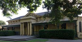 Ashford House, now part of the Ashford Special School | |||||||||||||||
| Population | 959 (2016 census)[1] | ||||||||||||||
| Postcode(s) | 5035 | ||||||||||||||
| LGA(s) | City of West Torrens | ||||||||||||||
| State electorate(s) | Badcoe | ||||||||||||||
| Federal division(s) | Adelaide | ||||||||||||||
| |||||||||||||||
Ashford is an inner southwestern suburb of Adelaide, in the City of West Torrens. It is triangular in shape and bordered by South Road (west), Anzac Highway (southeast) and Everard Avenue (north). Two of the main features of the suburb are Ashford Hospital and Ashford Special School.[2]
Brownhill Creek flows through Ashford in a cement channel behind the school.
The name commemorates the property and residence (now part of Ashford Special School) of Dr. Charles George Everard, who settled in the area in 1838, and named it for Ashford in Kent.
References[]
- ^ Australian Bureau of Statistics (27 June 2017). "Ashford (State Suburb)". 2016 Census QuickStats. Retrieved 22 December 2017.

- ^ Ashford Special School, ashfordsp.sa.edu.au
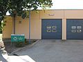
The SA Ambulance Service station, located at the intersection of Everard Avenue and Alexander Avenue
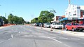
Anzac Highway, looking NE towards the city, with Ashford on the left and Everard Park on the right


Coordinates: 34°56′56″S 138°34′26″E / 34.949°S 138.574°E

This article about a place in Adelaide is a stub. You can help Wikipedia by . |
- Suburbs of Adelaide
- Adelaide geography stubs