Athensville Township, Greene County, Illinois
Athensville Township | |
|---|---|
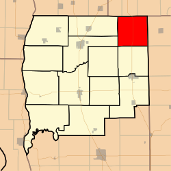 Location in Greene County | |
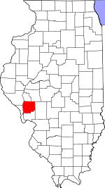 Greene County's location in Illinois | |
| Coordinates: 39°28′54″N 90°12′20″W / 39.48167°N 90.20556°WCoordinates: 39°28′54″N 90°12′20″W / 39.48167°N 90.20556°W | |
| Country | United States |
| State | Illinois |
| County | Greene |
| Established | November 4, 1884 |
| Area | |
| • Total | 35.74 sq mi (92.6 km2) |
| • Land | 35.73 sq mi (92.5 km2) |
| • Water | 0.01 sq mi (0.03 km2) 0.03% |
| Elevation | 541 ft (165 m) |
| Population (2010) | |
| • Estimate (2016)[1] | 323 |
| • Density | 9.6/sq mi (3.7/km2) |
| Time zone | UTC-6 (CST) |
| • Summer (DST) | UTC-5 (CDT) |
| ZIP codes | 62044, 62082 |
| FIPS code | 17-061-02700 |

Athensville Township is one of thirteen townships in Greene County, Illinois, USA. As of the 2010 census, its population was 343 and it contained 159 housing units.[2]
Geography[]
According to the 2010 census, the township has a total area of 35.74 square miles (92.6 km2), of which 35.73 square miles (92.5 km2) (or 99.97%) is land and 0.01 square miles (0.026 km2) (or 0.03%) is water.[2]
Unincorporated towns[]
(This list is based on USGS data and may include former settlements.)
Cemeteries[]
The township contains these 10 cemeteries: Athensville, Barnett Number 1, Ceres, Jackson, Old Hopper Homestead, Reeve-Mayberry, Richwoods, Rhodes, Sheppard and Union Prather.
Major highways[]
Demographics[]
| Historical population | |||
|---|---|---|---|
| Census | Pop. | %± | |
| 2016 (est.) | 323 | [1] | |
| U.S. Decennial Census[3] | |||
School districts[]
- Franklin Community Unit School District 1
- Greenfield Community Unit School District 10
- North Greene Unit School District 3
Political districts[]
- Illinois' 17th congressional district
- State House District 97
- State Senate District 49
References[]
- "Athensville Township, Greene County, Illinois". Geographic Names Information System. United States Geological Survey. Retrieved 2010-01-17.
- United States Census Bureau 2007 TIGER/Line Shapefiles
- United States National Atlas
- ^ a b "Population and Housing Unit Estimates". Retrieved June 9, 2017.
- ^ a b "Population, Housing Units, Area, and Density: 2010 - County -- County Subdivision and Place -- 2010 Census Summary File 1". United States Census. Archived from the original on 2020-02-12. Retrieved 2013-05-28.
- ^ "Census of Population and Housing". Census.gov. Retrieved June 4, 2016.
External links[]
Places adjacent to Athensville Township, Greene County, Illinois | |
|---|---|
Municipalities and communities of Greene County, Illinois, United States | ||
|---|---|---|
| Cities | ||
| Villages | ||
| Townships | ||
| Unincorporated communities | ||
| ||
Categories:
- Townships in Greene County, Illinois
- Townships in Illinois