Atiquipa District
Atiquipa | |
|---|---|
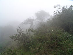 Garúa at the Lomas of Atiquipa | |
| Country | |
| Region | Arequipa |
| Province | Caravelí |
| Capital | |
| Government | |
| • Mayor | Fortunato Fernando Palomino Chalco |
| Area | |
| • Total | 423.55 km2 (163.53 sq mi) |
| Elevation | 325 m (1,066 ft) |
| Population (2005 census) | |
| • Total | 561 |
| • Density | 1.3/km2 (3.4/sq mi) |
| Time zone | UTC-5 (PET) |
| UBIGEO | 040304 |
Atiquipa District is one of thirteen districts of Caravelí Province in the Arequipa Region of Peru.[1]
Environment[]
Atiquipa is located in the coastal desert of Peru, an almost rainless area. However, heavy fogs and mists, called garúa, permit vegetation to grow on the mountain slopes of the district. This vegetated fog oasis is called the Lomas de Atiquipa, It is the largest and the best preserved fog oasis in Peru, covering more that 42,000 hectares (100,000 acres) with some 350 plant species, including 44 endemics. Conservation organizations are attempting to preserve and restore the environment of the lomas. Included in the project is the installation of fog-catching nets to capture water and thereby help the 80 families who live within the area to expand agriculture, primarily of olives.[2]
References[]
- ^ (in Spanish) Instituto Nacional de Estadística e Informática. Banco de Información Distrital Archived April 23, 2008, at the Wayback Machine. Retrieved April 11, 2008.
- ^ Peru: The Blessing of Water in Peru's Coastal Desert," The Nature Conservancy, http://www.nature.org/ourinitiatives/regions/southamerica/peru/explore/lomas-de-atiquipa.xml Archived 2017-08-21 at the Wayback Machine, accessed 17 Jul 2016
Coordinates: 15°48′30″S 74°21′46″W / 15.8084°S 74.3629°W

This Arequipa Region geography article is a stub. You can help Wikipedia by . |
- Districts of the Arequipa Region
- Districts of the Caravelí Province
- Arequipa Region geography stubs