Tisco District
Tisco | |
|---|---|
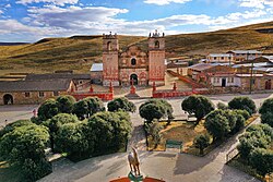 Tisco's church and main plaza | |
 Tisco Location of Tisco in the Caylloma province | |
| Coordinates: 15°20′51″S 71°26′46″W / 15.3476°S 71.4461°W | |
| Country | |
| Region | Arequipa |
| Province | Caylloma |
| Capital | |
| Government | |
| • Mayor | Primitivo Sebastian Huaracha Ancca |
| Area | |
| • Total | 1,445.02 km2 (557.93 sq mi) |
| Elevation | 4,188 m (13,740 ft) |
| Population (2005 census) | |
| • Total | 2,249 |
| • Density | 1.6/km2 (4.0/sq mi) |
| Time zone | UTC-5 (PET) |
| UBIGEO | 040517 |
Tisco District is one of twenty districts of the province Caylloma in Peru.[1]
Geography[]
Some of the highest mountains of the district are listed below:[2]
- Allqamari
- Apachita
- Chilluma
- Chuqi Pirwa
- Chuqi Phiruru
- Chuqi Tampu
- Janq'u
- Jañuma Pirwa
- Kallka K'uchu
- Kimsa Chata
- Kiska Kiska
- Kuntur Sayana
- Laramani
- Misa Urqu
- Pirwa
- Puma Urqu
- Qillqa
- Qillwa
- Q'ara Qullu
- Q'iwiri
- Wallatani
- Wayna Kunturiri
- Wila Pukara
- Wiluma
- Wiska Apachita
- Wisk'achayuq
- Wiswillani

Entrance to Tisco's main plaza through its gate

Church of San Pedro Apostol de Tisco, with Plaza in foreground

The village of Tisco as seen from the air
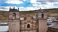
The towers of Tisco's church
Ethnic groups[]
The people in the district are mainly indigenous citizens of Quechua descent. Quechua is the language which the majority of the population (86.76%) learnt to speak in childhood, 13.06% of the residents started speaking using the Spanish language (2007 Peru Census).[3]
See also[]
- Samaquta
References[]
- ^ (in Spanish) Instituto Nacional de Estadística e Informática. Banco de Información Distrital Archived 2008-04-10 at the Wayback Machine. Retrieved April 11, 2008.
- ^ escale.minedu.gob.pe - UGEL maps of the Caylloma Province 1 and 2 (Arequipa Region)
- ^ inei.gob.pe Archived 2013-01-27 at the Wayback Machine INEI, Peru, Censos Nacionales 2007, Frequencias: Preguntas de Población: Idioma o lengua con el que aprendió hablar (in Spanish)
Coordinates: 15°20′51″S 71°26′46″W / 15.3476°S 71.4461°W
This Arequipa Region geography article is a stub. You can help Wikipedia by . |
Categories:
- Districts of the Arequipa Region
- Districts of the Caylloma Province
- Arequipa Region geography stubs