Atomic City, Idaho
Atomic City, Idaho | |
|---|---|
 Downtown Atomic City | |
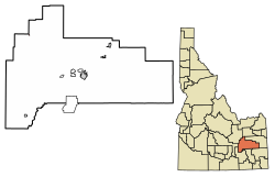 Location of Atomic City in Bingham County, Idaho. | |
 Atomic City Location in Idaho | |
| Coordinates: 43°26′33″N 112°48′47″W / 43.44250°N 112.81306°WCoordinates: 43°26′33″N 112°48′47″W / 43.44250°N 112.81306°W | |
| Country | United States |
| State | Idaho |
| County | Bingham |
| Area | |
| • Total | 0.08 sq mi (0.21 km2) |
| • Land | 0.08 sq mi (0.21 km2) |
| • Water | 0.00 sq mi (0.00 km2) |
| Elevation | 5,013 ft (1,528 m) |
| Population | |
| • Total | 29 |
| • Estimate (2019)[3] | 27 |
| • Density | 341.77/sq mi (131.33/km2) |
| Time zone | UTC-7 (Mountain (MST)) |
| • Summer (DST) | UTC-6 (MDT) |
| ZIP code | 83215 |
| Area codes | 208, 986 |
| FIPS code | 16-03970 |
| GNIS feature ID | 0397396 |


Atomic City is a city in Bingham County, Idaho, United States. The population was 29 at the 2010 census, up from 25 in 2000.[4]
History[]
Atomic City was called "Midway" until 1950, as it is halfway between the towns of Blackfoot and Arco. It was home of Experimental Breeder Reactor I, the world's first electricity-generating nuclear power plant. The town had a larger population when the neighboring Idaho National Laboratory site was newer, known as the "National Reactor Testing Station" until 1975.
There is one store and one bar in Atomic City; the store no longer sells gasoline, due to new laws pertaining to its underground gas tanks. Most of the people who were raised in the town are now[when?] deceased, and many of the current[when?] residents are retired. There is an RV park on the south end of town with full hook-ups, and stock car races are held in the summer.
Geography[]
According to the United States Census Bureau, the city has a total area of 0.11 square miles (0.28 km2), all of it land.[5]
Atomic City is just south of the Idaho National Laboratory site, on U.S. Route 26.
Climate[]
According to the Köppen Climate Classification system, Atomic City has a semi-arid climate, abbreviated "BSk" on climate maps.[6]
Demographics[]
2010 census[]
| Historical population | |||
|---|---|---|---|
| Census | Pop. | %± | |
| 1960 | 141 | — | |
| 1970 | 24 | −83.0% | |
| 1980 | 34 | 41.7% | |
| 1990 | 25 | −26.5% | |
| 2000 | 25 | 0.0% | |
| 2010 | 29 | 16.0% | |
| 2019 (est.) | 27 | [3] | −6.9% |
| U.S. Decennial Census[7] | |||
At the 2010 census there were 29 people in 17 households, including 9 families, in the city. The population density was 263.6 inhabitants per square mile (101.8/km2). There were 48 housing units at an average density of 436.4 per square mile (168.5/km2). The racial makeup of the city was 96.6% White and 3.4% Native American. Hispanic or Latino of any race were 3.4%.[2]
Of the 17 households 52.9% were married couples living together and 47.1% were non-families. 35.3% of households were made up of individuals. The average household size was 1.71 and the average family size was 2.11.
The median age was 59.8 years. 0.0% of residents were under the age of 18; 0.0% were between the ages of 18 and 24; 6.9% were from 25 to 44; 58.6% were from 45 to 64; and 34.5% were 65 or older. The gender makeup of the city was 48.3% male and 51.7% female.
2000 census[]
As of the census[8] of 2000, there were 25 people in 16 households, including 7 families, in the city. The population density was 245.4 people per square mile (96.5/km2). There were 22 housing units at an average density of 216.0 per square mile (84.9/km2). 24 of the residents were White, and one was Asian.
Of the 16 households one has a child under the age of 18 living with them, six were married couples living together, and nine were non-families. Nine households were made up of individuals, and two had someone living alone who was 65 or older. The average household size was 1.56 and the average family size was 2.29.
The age distribution was one person under the age of 18, one from 18 to 24, two from 25 to 44, twelve from 45 to 64, and eight who were 65 or older. The median age was 58 years. Ten citizens were females and fifteen were males; one of the males was under 18.
The median household income was $9,375 and the median family income was $8,750. Males had a median income of $43,750 versus $8,750 for females. The per capita income for the city was $16,276. 57.1% of the population and 62.5% of families were below the poverty line. None of those under 18 and half of those 65 and older were living below the poverty line.
References[]
- ^ "2019 U.S. Gazetteer Files". United States Census Bureau. Retrieved July 9, 2020.
- ^ Jump up to: a b "U.S. Census website". United States Census Bureau. Retrieved 2012-12-18.
- ^ Jump up to: a b "Population and Housing Unit Estimates". United States Census Bureau. May 24, 2020. Retrieved May 27, 2020.
- ^ Spokesman-Review Archived 2016-03-04 at the Wayback Machine - 2010 census - Atomic City, Idaho - accessed 2011-12-28
- ^ "US Gazetteer files 2010". United States Census Bureau. Archived from the original on 2012-01-25. Retrieved 2012-12-18.
- ^ Climate Summary for Atomic City, Idaho
- ^ "Census of Population and Housing". Census.gov. Retrieved June 4, 2015.
- ^ "U.S. Census website". United States Census Bureau. Retrieved 2008-01-31.
External links[]
- [1] City Web Page
- Atomic City USA.com
- Roadside America.com - Atomic City
- Untraveled Road.com - Atomic City
| show Municipalities and communities of Bingham County, Idaho, United States |
|---|
| show Authority control |
|---|
- Cities in Bingham County, Idaho
- Cities in Idaho