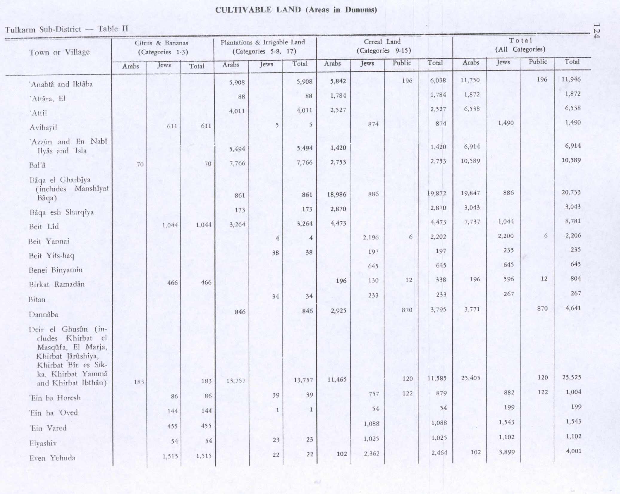
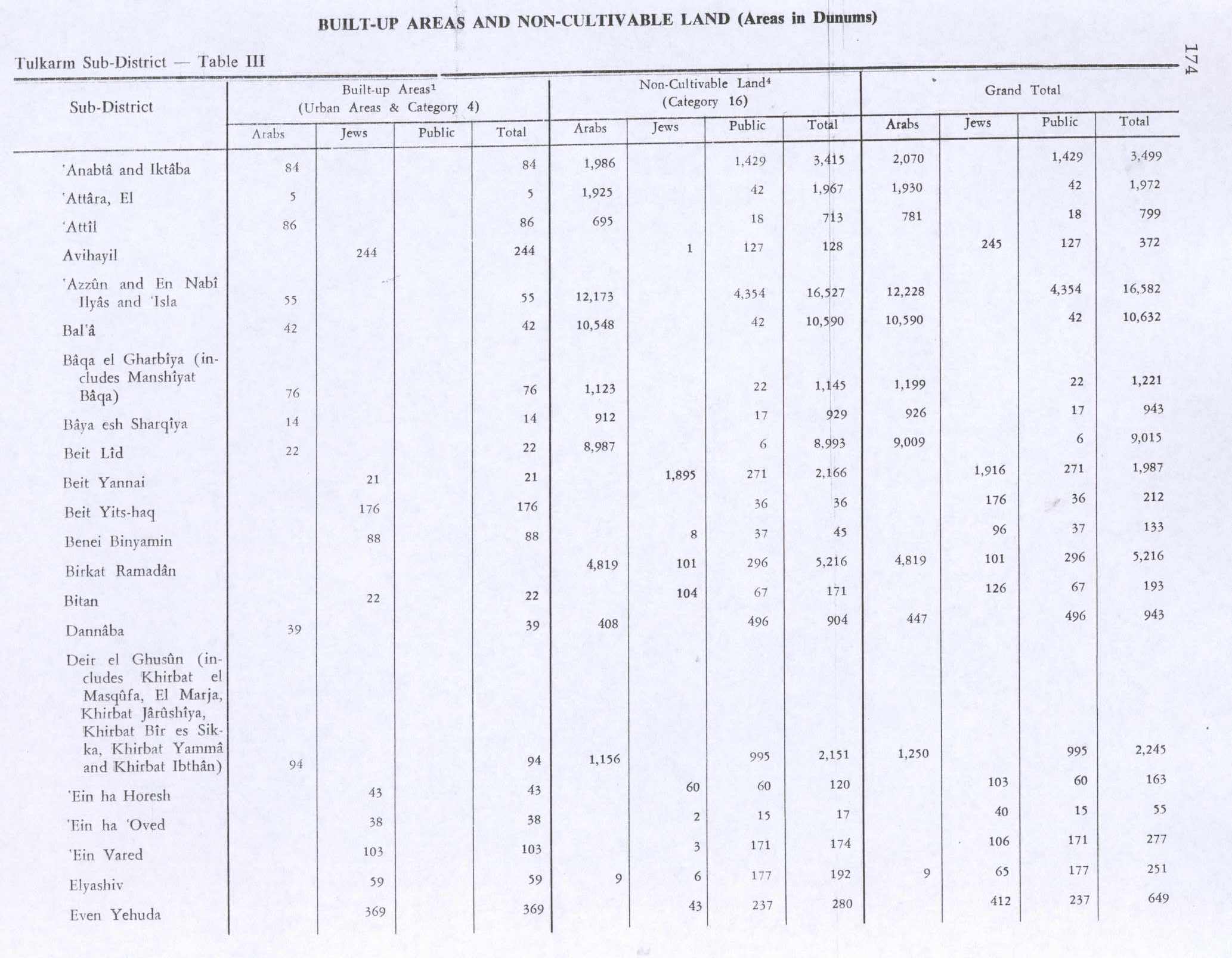
Attil
Attil | |
|---|---|
Municipality type C | |
| Arabic transcription(s) | |
| • Arabic | عتيل |
 Attil Location of Attil within Palestine | |
| Coordinates: 32°22′10″N 35°04′18″E / 32.36944°N 35.07167°ECoordinates: 32°22′10″N 35°04′18″E / 32.36944°N 35.07167°E | |
| Palestine grid | 156/197 |
| State | State of Palestine |
| Governorate | Tulkarm |
| Government | |
| • Type | Municipality |
| Area | |
| • Total | 7,337 dunams (7.3 km2 or 2.8 sq mi) |
| Population (2007) | |
| • Total | 9,038 |
| • Density | 1,200/km2 (3,200/sq mi) |
| Name meaning | Attil, "severe"[1] |

Attil (Arabic: عتيل) is a Palestinian town in the Tulkarm Governorate in the eastern West Bank, 12 km (7.5 mi) northeast of Tulkarm. Attil is the connection point between the other villages and Tulkarm. It is bordered by Illar to the east; Baqa ash-Sharqiyya to the north; The Green Line to the west; and Deir al-Ghusun to the south. Mountains surrounding the town include the Nabhan, Aboora, Asad, and Shehadeh mountains. Attil has an elevation of 100 m (330 ft) above Sea level, and an area of 7.337 km2.
History[]
Attil is an ancient village site on a hill at the edge of the plains.[2] Pottery remain have been found here from Middle Bronze Age II, Iron Age I and IA II, Persian, Hellenistic, early and late Roman, Byzantine, early Muslim and the Middle Ages have been found here.[3] Fragmentary mosaic floors and column shafts from a church have been found, together with cisterns dug into the rock, as well as caves.[2]
In 1179, it was mentioned in Crusader sources as Azatil.[4] In March 1265, when Sultan Baibars awarded his officers lands, he gave Attil “To the Atabek Faris al-Din Uqtay al-Salihi“.[5]
Ottoman era[]
Attil, like the rest of Palestine, was incorporated into the Ottoman Empire in 1517, and in the census of 1596 it was a part of the nahiya ("subdistrict") of Jabal Sami which was under the administration of the liwa ("district") of Nablus. The village had a population of 59 households, all Muslim, and paid taxes on wheat, barley, summer crops, olive trees, occasional revenues, beehives and/or goats, and an olive oil press, or press for grape syrup; a total of 14,872 akçe.[6]
In 1838 it was noted as a village, 'Attil, in the western Esh-Sha'rawiyeh administrative region, north of Nablus.[7]
In the late Ottoman period, in 1852, the American scholar Edward Robinson described passing by the villages of Zeita and Jatt on the way to 'Attil. Of 'Attil itself, he writes that it was "a considerable village," located on a hill with plains to the north and south. He further noted: ”It appears, that the land in the district of Nabulus including the plains, is generally freehold; and the taxes are mainly paid in the form of a poll tax.”[8]
In 1863, the French explorer Victor Guérin passed by and noted that the village was also called Deir Attil.[9]
In 1882 the PEF's Survey of Western Palestine described the village as being of considerable size, situated on a hill on the edge of the plain, and surrounded by a small olive-grove, and supplied by cisterns.[10]
British Mandate era[]
In the 1922 census of Palestine conducted by the British Mandate authorities, Attil had a population of 1,656, all Muslims.[11] At the time of the 1931 census of Palestine, Attil, together with Jalama, Al-Manshiyya and Zalafa had a total of 2207 persons, all Muslim except 1 Druze, living in 473 houses.[12]
In the 1945 statistics the population of Attil was 2,650, all Muslims,[13] who owned 7,337 dunams of land according to an official land and population survey.[14] 4,011 dunams were plantations and irrigable land, 2,527 used for cereals,[15] while 86 dunams were built-up (urban) land.[16]

Attil 1942 1:20,000

Attil 1945 1:250,000

Jordanian era[]
In the wake of the 1948 Arab–Israeli War, and after the 1949 Armistice Agreements, Attil came under Jordanian rule. It was annexed by Jordan in 1950.
In 1961, the population was 4,087.[17]
Post-1967[]
Since the Six-Day War in 1967, Attil has been under Israeli occupation.
Population[]
Attil had a population of 9,038 in the 2007 census by the Palestinian Central Bureau of Statistics.[18] The majority of its people are expatriates living in Jordan, various states in the Persian Gulf, the United States, Europe, and other parts of the world.
References[]
- ^ Palmer, 1881, p. 179
- ^ Jump up to: a b Dauphin, 1998, p. 757
- ^ Zertal, 2016, p. 416
- ^ Röhricht, 1887, p. 245; cited in Zertal, 2016, p. 416
- ^ Ibn al-Furat, trans. Lyons, 1971, p. 80; cited in Zertal, 2016, p. 417
- ^ Hütteroth and Abdulfattah, 1977, p. 126
- ^ Robinson and Smith, 1841, vol 3, 2nd Appendix, p. 129
- ^ Robinson and Smith, 1856, p. 124.
- ^ Guérin, 1875, p. 345
- ^ Conder and Kitchener, 1882, SWP II, p. 151
- ^ Barron, 1923, Table XI, Sub-district of Tulkarm, p. 27
- ^ Mills, 1932, p. 53
- ^ Government of Palestine, Department of Statistics, 1945, p. 20
- ^ Government of Palestine, Department of Statistics. Village Statistics, April, 1945. Quoted in Hadawi, 1970, p. 74
- ^ Government of Palestine, Department of Statistics. Village Statistics, April, 1945. Quoted in Hadawi, 1970, p. 124
- ^ Government of Palestine, Department of Statistics. Village Statistics, April, 1945. Quoted in Hadawi, 1970, p. 174
- ^ Government of Jordan, Department of Statistics, 1964, p. 13
- ^ 2007 PCBS census. Palestinian Central Bureau of Statistics (PCBS). p. 107.
Bibliography[]
- Barron, J.B., ed. (1923). Palestine: Report and General Abstracts of the Census of 1922. Government of Palestine.
- Conder, C.R.; Kitchener, H.H. (1882). The Survey of Western Palestine: Memoirs of the Topography, Orography, Hydrography, and Archaeology. 2. London: Committee of the Palestine Exploration Fund.
- Dauphin, Claudine (1998). La Palestine byzantine, Peuplement et Populations. BAR International Series 726 (in French). III : Catalogue. Oxford: Archeopress. ISBN 0-860549-05-4.
- Government of Jordan, Department of Statistics (1964). First Census of Population and Housing. Volume I: Final Tables; General Characteristics of the Population (PDF).
- Government of Palestine, Department of Statistics (1945). Village Statistics, April, 1945.
- Guérin, V. (1875). Description Géographique Historique et Archéologique de la Palestine (in French). 2: Samarie, pt. 2. Paris: L'Imprimerie Nationale.
- Hadawi, S. (1970). Village Statistics of 1945: A Classification of Land and Area ownership in Palestine. Palestine Liberation Organization Research Centre.
- Hütteroth, Wolf-Dieter; Abdulfattah, Kamal (1977). Historical Geography of Palestine, Transjordan and Southern Syria in the Late 16th Century. Erlanger Geographische Arbeiten, Sonderband 5. Erlangen, Germany: Vorstand der Fränkischen Geographischen Gesellschaft. ISBN 3-920405-41-2.
- Ibn al-Furat (1971). J. Riley-Smith (ed.). Ayyubids, Mamluks and Crusaders: Selections from the "Tarikh Al-duwal Wal-muluk" of Ibn Al-Furat : the Text, the Translation. 2. Translation by Malcolm Cameron Lyons, Ursula Lyons. Cambridge: W. Heffer.
- Mills, E., ed. (1932). Census of Palestine 1931. Population of Villages, Towns and Administrative Areas. Jerusalem: Government of Palestine.
- Palmer, E.H. (1881). The Survey of Western Palestine: Arabic and English Name Lists Collected During the Survey by Lieutenants Conder and Kitchener, R. E. Transliterated and Explained by E.H. Palmer. Committee of the Palestine Exploration Fund.
- Robinson, E.; Smith, E. (1841). Biblical Researches in Palestine, Mount Sinai and Arabia Petraea: A Journal of Travels in the year 1838. 3. Boston: Crocker & Brewster.
- Robinson, E.; Smith, E. (1856). Later Biblical Researches in Palestine and adjacent regions: A Journal of Travels in the year 1852. London: John Murray.
- Röhricht, R. (1887). "Studien zur mittelalterlichen Geographie und Topographie Syriens". Zeitschrift des Deutschen Palästina-Vereins. 10: 195–344.
- Zertal, A. (2016). The Manasseh Hill Country Survey. 3. Boston: BRILL. ISBN 9004312307.
External links[]
- Welcome To 'Attil
- Attil, Welcome to Palestine
- Survey of Western Palestine, Map 11: IAA, Wikimedia commons

- Tulkarm Governorate
- Towns in the West Bank
- Municipalities of the State of Palestine