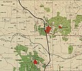
Jatt, Israel
Jatt
| |
|---|---|
Local council | |
 | |
 Jatt | |
| Coordinates: 32°23′58″N 35°02′12″E / 32.39944°N 35.03667°ECoordinates: 32°23′58″N 35°02′12″E / 32.39944°N 35.03667°E | |
| Grid position | 153/200 PAL |
| Country | |
| District | |
| Population (2019)[1] | |
| • Total | 12,100 |
| Name meaning | wine-press[2] |


Jatt (Arabic: جت; Hebrew: גַ'ת) is an Arab local council in the Triangle area of Haifa District in Israel. In 2019 it had a population of 12,100.[1]
History[]
Antiquity[]
Archaeologists excavations have yielded remains from Early Bronze Age and Middle Bronze Age. Both local and imported pottery from this period has been found. A scarab, in bone, dating to the 1750–1550 BCE has also been found.[3]
Two Roman lamps have been found here.[4][5][6]
Archeological excavations have revealed major remains from the Byzantine and the Mamluk eras.[7][8]
Ottoman era[]
Jatt, like the rest of Palestine, was incorporated into the Ottoman Empire in 1517, and in the census of 1596, the village was located in the nahiya of Sara in the liwa of Lajjun. It had a population of 5 households, all Muslim. It paid a fixed tax of 25% on agricultural products, including wheat, barley, summer crops, goats and beehives, in addition to occasional revenues; the taxes totalled 5,500 akçe.[9]
In 1870, Victor Guérin noted here: "Several ancient cisterns are scattered about on the rocky plateau upon which stands Jett. The houses are rudely built. In the midst of the small materials of which they are principally constructed I observed a certain number of cut stones of ancient date. In the courtyard of one house I found an old capital of white marble hollowed to serve as a mortar, and now used to grind coffee. At the foot of the hill is a well, which probably is of ancient date."[10] He further noted that Jatt had fourteen hundred inhabitants.[11]
In 1882, the Palestine Exploration Fund's Survey of Western Palestine described it: "Evidently an ancient site ; a moderate-sized village of mud and stone on a high mound at the edge of the plain. It stands beside the main road to the north, near the junction with that from Shechem, and about 2 1/2 miles north of the road through Attil to the great plain. The village is surrounded with wells, and has a few olives on the west. There are caves to the north, and springs about a mile to the north-west.[..] It may also perhaps be the Jethu, or Gath, of Thothmes III, a place north of the road which he pursued to Megiddo."[12]
British Mandate era[]
In the 1922 census of Palestine conducted by the British Mandate authorities, Jatt had a population of 680 Muslims,[13] increasing in the 1931 census to 780 Muslim, living in 165 houses.[14]
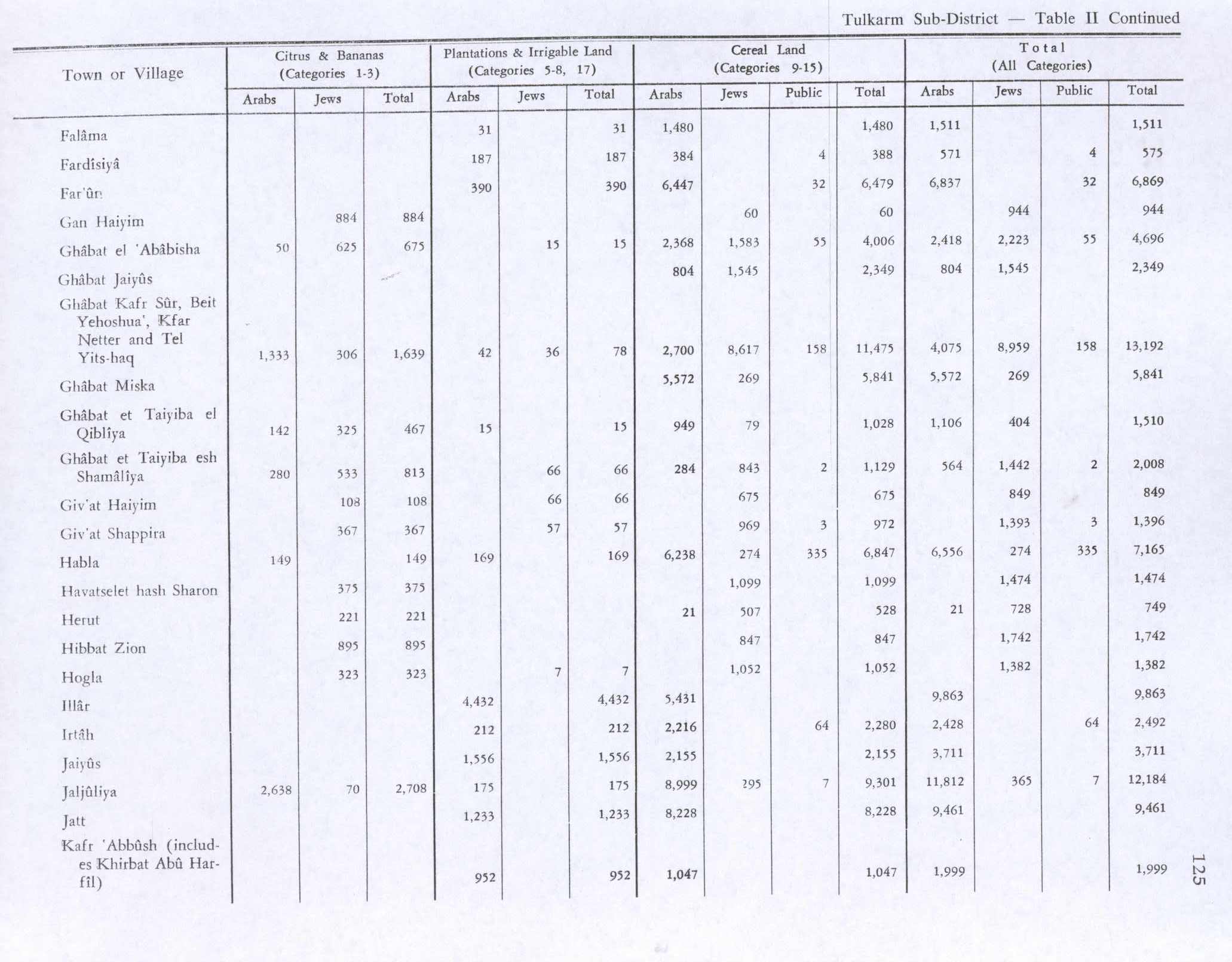
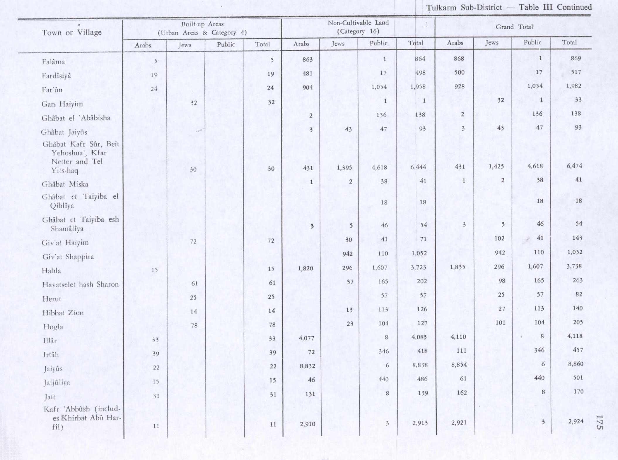
In the 1945 statistics the population of Jatt was 1,120 Muslims,[15] with a total of 9,631 dunams of land according to an official land and population survey.[16] 1,233 dunams were plantations and irrigable land, 8,228 used for cereals,[17] while 31 dunams were built-up (urban) land.[18]
Jatt 1942 1:20,000

Jatt 1945 1:250,000


Israeli era[]
In 1959 the town was declared a local council. In 2003 Jatt was merged with nearby Baqa al-Gharbiyye to form the city of Baqa-Jatt. However, the merger was reversed in 2010.
Politics[]
Direct elections were held for the mayoralty for the first time in the 1960s, with Ali Abdul-Razzaq Malak, succeeded by Sharif Jameel Gara. Then in 1973, Ahmed Mahmoud Abu Asba was elected; he was re-elected for a second term in 1983. The 1988 elections were won by Galal Abd al-Kader Wattad, and in 1993 Ahmed Mahmoud Abu Asba returned to the mayoralty. The 1998 elections were won by Dr. Mohammad Hassan Abu Foul.
Following the local council's re-establishment in 2010, Khaled Gharra was elected mayor. Khaled Gharra was succeeded by Muhammad Taher Wattad and was reelected in 2019.[19] Former Knesset Member and writer Muhammed Wattad was from Jatt.
References[]
- ^ Jump up to: a b "Population in the Localities 2019" (XLS). Israel Central Bureau of Statistics. Retrieved 16 August 2020.
- ^ Palmer, 1881, p. 183
- ^ Said, 2006, Jatt, Final Report
- ^ Conder, 1881, pp. 196-7
- ^ Conder and Kitchener, 1882, SWP II, p. 193
- ^ Conder and Kitchener, 1883, SWP III, p. 438
- ^ Massarwa, 2010, Jatt, Final Report
- ^ Said, 2005, Tell Jatt, Final Report
- ^ Hütteroth and Abdulfattah, 1977, p. 159
- ^ Guérin, 1875, pp. 345-6; as given in Conder and Kitchener, 1882, SWP II, pp. 193-4
- ^ Guérin, 1875, p. 345
- ^ Conder and Kitchener, 1882, SWP II, p. 152
- ^ Barron, 1923, Table XI, Sub-district of Tulkarm, p. 27
- ^ Mills, 1932, p. 55
- ^ Department of Statistics, 1945, p. 20
- ^ Government of Palestine, Department of Statistics. Village Statistics, April, 1945. Quoted in Hadawi, 1970, p. 75
- ^ Government of Palestine, Department of Statistics. Village Statistics, April, 1945. Quoted in Hadawi, 1970, p. 125
- ^ Government of Palestine, Department of Statistics. Village Statistics, April, 1945. Quoted in Hadawi, 1970, p. 175
- ^ "الانتخابات في الطيبة ، باقة وجت - اليكم النتائج بالارقام".
Bibliography[]
- Abu Hamid, Amani (2010-09-12). "Jatt Final Report" (122). Hadashot Arkheologiyot – Excavations and Surveys in Israel. Cite journal requires
|journal=(help) - ‘Awawdy, Eiad (2007-06-14). "Tell Jatt Final Report" (119). Hadashot Arkheologiyot – Excavations and Surveys in Israel. Cite journal requires
|journal=(help) - Barron, J.B., ed. (1923). Palestine: Report and General Abstracts of the Census of 1922. Government of Palestine.
- Conder, C.R. (1881). "Jatt". Quarterly Statement - Palestine Exploration Fund. 13: 196–197.
- Conder, C.R.; Kitchener, H.H. (1882). The Survey of Western Palestine: Memoirs of the Topography, Orography, Hydrography, and Archaeology. 2. London: Committee of the Palestine Exploration Fund.
- Conder, C.R.; Kitchener, H.H. (1883). The Survey of Western Palestine: Memoirs of the Topography, Orography, Hydrography, and Archaeology. 3. London: Committee of the Palestine Exploration Fund.
- Dauphin, Claudine (1998). La Palestine byzantine, Peuplement et Populations. BAR International Series 726 (in French). III : Catalogue. Oxford: Archeopress. ISBN 0-860549-05-4.
- Department of Statistics (1945). Village Statistics, April, 1945. Government of Palestine.
- Guérin, V. (1875). Description Géographique Historique et Archéologique de la Palestine (in French). 2: Samarie, pt. 2. Paris: L'Imprimerie Nationale.
- Hadawi, S. (1970). Village Statistics of 1945: A Classification of Land and Area ownership in Palestine. Palestine Liberation Organization Research Center.
- Hütteroth, Wolf-Dieter; Abdulfattah, Kamal (1977). Historical Geography of Palestine, Transjordan and Southern Syria in the Late 16th Century. Erlanger Geographische Arbeiten, Sonderband 5. Erlangen, Germany: Vorstand der Fränkischen Geographischen Gesellschaft. ISBN 3-920405-41-2.
- Masarwa, Marwan (2004-05-31). "Jatt Final Report" (116). Hadashot Arkheologiyot – Excavations and Surveys in Israel. Cite journal requires
|journal=(help) - Massarwa, Abdallah (2010-11-04). "Jatt Final Report" (122). Hadashot Arkheologiyot – Excavations and Surveys in Israel. Cite journal requires
|journal=(help) - Massarwa, Abdallah (2012-07-22). "Jatt Final Report" (124). Hadashot Arkheologiyot – Excavations and Surveys in Israel. Cite journal requires
|journal=(help) - Mills, E., ed. (1932). Census of Palestine 1931. Population of Villages, Towns and Administrative Areas. Jerusalem: Government of Palestine.
- Palmer, E.H. (1881). The Survey of Western Palestine: Arabic and English Name Lists Collected During the Survey by Lieutenants Conder and Kitchener, R. E. Transliterated and Explained by E.H. Palmer. Committee of the Palestine Exploration Fund.
- Sa‘id, Kareem (2004-05-31). "Jatt Final Report" (116). Hadashot Arkheologiyot – Excavations and Surveys in Israel. Cite journal requires
|journal=(help) - Sa‘id, Kareem (2005-10-02). "Tell Jatt Final Report" (117). Hadashot Arkheologiyot – Excavations and Surveys in Israel. Cite journal requires
|journal=(help) - Sa‘id, Kareem (2006-06-25). "Jatt Final Report" (118). Hadashot Arkheologiyot – Excavations and Surveys in Israel. Cite journal requires
|journal=(help)
External links[]
- Welcome To Jatt
- Survey of Western Palestine, Map 11: IAA, Wikimedia commons
| hide | ||
|---|---|---|
| Cities | ||
| Local councils | ||
| Regional councils | ||
| See also |
| |
- Haifa District
- Arab localities in Israel
- Local councils in Haifa District
- 19th-century establishments in Ottoman Syria