Pardes Hanna-Karkur
Pardes Hanna-Karkur
פַּרְדֵּס חַנָּה-כַּרְכּוּר | |
|---|---|
Local council | |
| Hebrew transcription(s) | |
| • ISO 259 | Pardes Ḥanna - Karkur |
 | |
|
| |
 Pardes Hanna-Karkur | |
| Coordinates: 32°28′16″N 34°58′03″E / 32.47111°N 34.96750°ECoordinates: 32°28′16″N 34°58′03″E / 32.47111°N 34.96750°E | |
| Country | |
| District | |
| Founded | 1969 |
| Government | |
| • Head of Municipality | Hagar Peri Yagur |
| Area | |
| • Total | 22,596 dunams (22.596 km2 or 8.724 sq mi) |
| Population (2019)[1] | |
| • Total | 43,011 |
| • Density | 1,900/km2 (4,900/sq mi) |


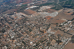
Pardes Hanna-Karkur (Hebrew: פַּרְדֵּס חַנָּה-כַּרְכּוּר) is a town in the Haifa District of Israel. In 2019 it had a population of 43,011.[1]
History[]
An Arab village named Kerkur had stood at this location by the time the Palestine Exploration Fund had compiled its first maps in 1878.[2]
In 1913, 15 square kilometers of land was purchased by the Hachsharat Hayishuv society from Arabs in Jenin and Haifa for 400,000 francs (a sum equivalent to 2 million US dollars).[3] Two years later, the land was sold to a private investor, Yitzhak Shlezinger, the Odessa Committee and the First London Ahuza society. This land became the core of Karkur, Moshav Gan Hashomron and Kibbutz Ein Shemer. Until actual settlement began, the area was guarded by Hashomer, which planted eucalyptus trees to circumvent a Turkish law that allowed the Ottomans to expropriate lands if they were not cultivated for three years.[3]
The early settlements did not fare well. Shlezinger went bankrupt and sold his land to the Jewish National Fund. The London Ahuza society hoped to settle English Jews on the land, but succeeded only partially. Eventually the Jewish National Fund and the London Ahuza society joined forces to establish Karkur.[3]
According to a census conducted in 1922 by the British Mandate authorities, Karkur had a population of 38 inhabitants, consisting of 35 Jews and 3 Muslims.[4] By 1931, Karkur has grown to 189 houses, with an overwhelming Muslim majority (282 Jews and 564 Muslims);[5] yet by 1945, all Muslims had left, and its population was recorded as 2380, all Jews.[6]
During World War II, residents worked in Ein Shemer Airfield, operated by the British Royal Air Force as RAF Ein Shemer. According to Marom, "Jewish workers socialised with British troops at nearby coffeehouses like Teacher’s Garden Caf�e and other public institutions in Karkur. Jewish residents of Karkur nicknamed their settlement a ‘colony of love’ because many English-speaking women fraternised with the British soldiers, under the auspices of the local Jewish Hospitality Committee."[7]
Pardes Hanna (lit. "Hanna's orchard", also "Pardes Chana") was founded in 1929 by Palestine Jewish Colonisation Association and named after Hannah Rothschild, daughter of Baron Mayer de Rothschild.
On 6 April 1948, the Irgun raided the British Army camp at Pardes Hanna, killing seven British soldiers and stealing a large quantity of weapons.[8]
After Israeli independence, Neveh Efraim was founded by Jewish immigrants from Yemen and Neve Oved was established by the Labor movement.[3] In addition, many Jews from Mumbai, India, including Jews from Bahrain who fled to Israel via Mumbai, settled there.
In the 1950s, the villages Tel Shalom and Neve Efraim were merged with Pardes Hanna. Pardes Hanna and Karkur merged in 1969.

Kerkur 1878 1:63,360

Karkur 1928
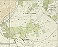
Pardes Hanna (Rabye) and Kerkur 1932 1:20,000

Great synagogue of Pardes Hanna, established in 1936
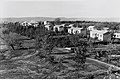
Pardes Hanna, 1938

Pardes Hanna water tower 1930

Pardes Hanna and Karkur 1945 1:250,000
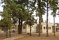
Beit Harishonim, Pardes Hanna


Demographics[]
According to the Israel Central Bureau of Statistics, the population of Pardes Hanna-Karkur was 43,011 at end of 2019. The land area is 22,596 dunams (~22.6 km2 [8.7 sq mi]). Pardes-Hanna is governed by the largest local council in Israel by population size (among towns without municipal status).
Education[]
The oldest and largest school in Pardes Hanna-Karkur is the Pardes Hanna Agricultural High School. It was established in 1934 by the Association of Farmers and was the first agricultural school to include a full academic matriculation program as part of its curriculum.[9] Pardes Hanna-Karkur has six non-religious elementary schools, including a Democratic school, and four religious elementary schools, as well as the Rimon Waldorf School. A religious high-school for boys, Midrashiat Noam, was once considered the flagship of religious-Zionist education. Its graduates include former ministers Yitzhak Peretz, Benny Elon and Ya'akov Ne'eman; journalists Haim Zisowitz, Yair Sheleg and Adam Baruch; and Labor Party Secretary-General Eitan Cabel.[10] A religious high school for girls, Elisheva, is also located in Pardes Hanna.[3]
Transportation[]
Pardes Hanna-Karkur is served by the Caesarea-Pardes Hanna Railway Station and by buses run by Egged and Kavim. It is connected to Highway 4 by Road 651, to Highway 65 by Roads 650,652 and 6502, and to Highway 70 by road 652.
Notable residents[]
- Gal Fridman, Olympic gold medal-winning windsurfer
- Eden Hason, Mizrahi singer
- Pe'er Tasi, Mizrahi singer.
- Yona & Nina Tokayer A.K.A. Yonina, Famous musical couple.
See also[]
References[]
| Wikimedia Commons has media related to Pardes Hanna-Karkur. |
- ^ Jump up to: a b "Population in the Localities 2019" (XLS). Israel Central Bureau of Statistics. Retrieved 16 August 2020.
- ^ Marom, Roy (9 June 2021). "The Abu Hameds of Mulabbis: an oral history of a Palestinian village depopulated in the Late Ottoman period". British Journal of Middle Eastern Studies. 0: 2. doi:10.1080/13530194.2021.1934817. ISSN 1353-0194.
- ^ Jump up to: a b c d e Pardes Hanna-Karkur, A General Real Estate Overview
- ^ [1]
- ^ https://archive.org/details/CensusOfPalestine1931.PopulationOfVillagesTownsAndAdministrativeAreas
- ^ http://users.cecs.anu.edu.au/~bdm/yabber/census/VillageStatistics1945orig.pdf
- ^ Marom, Roy (2 July 2020). "RAF Ein Shemer: A Forgotten Case of Jewish and Arab Work in a British Army Camp in Palestine during the Second World War". War & Society. 39 (3): 203. doi:10.1080/07292473.2020.1786889. ISSN 0729-2473.
- ^ The Scotsman: 17, 18 April. Yaakov Meridor was reported to have been in command of the Irgun attackers. Those dead included Lieut-Colonel G.L. Hildebrand, Royal Artillery
- ^ "About Pardes Hanna-Karkur". Archived from the original on 4 March 2012. Retrieved 14 September 2010.
- ^ An educator's legacy
| show Authority control |
|---|
- Haifa District
- Pardes Hanna-Karkur
- Populated places established in 1969
- Local councils in Haifa District
- 1969 establishments in Israel