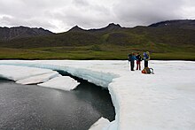
Aufeis

Aufeis, (/ˈaʊfaɪs/ OW-fyse), (German for "ice on top") is a sheet-like mass of layered ice that forms from successive flows of ground water during freezing temperatures. This form of ice is also called overflow, icings, or the Russian term, naled. The term was first used in 1859 by A. T. von Middendorff following his observations of the phenomenon in northern Siberia.[1][2]
Formation[]
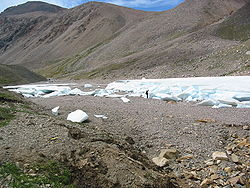
Aufeis accumulates during winter along stream and river valleys in arctic and subarctic environments. It forms by upwelling of river water behind ice dams, or by ground-water discharge. The latter mechanism prevails in high-gradient alpine streams as they freeze solid. Ground-water discharge is blocked by ice, perturbing the steady-state condition and causing a small incremental rise in the local water table until discharge occurs along the bank and over the top of the previously formed ice. Successive ice layers can lead to aufeis accumulations that are several meters thick. Aufeis typically melts out during summer and will often form in the same place year after year.[3]
Impact[]
Sheets of aufeis may block stream channels and cause their flood plains to widen as spring floodwaters are forced to flow around the ice.[4] Research on aufeis has to a large extent been motivated by the variety of engineering problems the ice sheets can cause (e.g. blocking drainages and causing flooding of roads).[5] Culverts and pipelines can actually help to block flow and lead to the development of more extensive aufeis.[6]
Aufeis can present an extreme danger to recreational boaters even during summer months, who can find themselves trapped between walls of ice or pulled under aufeis by the current of the river. Breaking dams of aufeis can also cause flash floods downriver.[7] Proper scouting and precautions when choosing campsites can minimize these risks[citation needed].
City cooling[]
In late 2011, Mongolia planned to test the use and storage of artificial naleds as a way of cooling Ulan Bator in the hot Mongolian summer, and reducing the use of energy-intensive air conditioning.[8]
Occurrence[]
Sheets of aufeis have been observed in Alaska,[4][5] Arctic Canada,[9][10][11][12] Russia,[13][14] and Mongolia.[15][16]
Analysis of satellite imagery from 2000-2015 has shown that the extent and duration of many Alaskan river icings has decreased.[17]
Notes[]
- ^ Ashton, George D. 1986. River and lake ice engineering. Chelsea, Michigan, USA: Book Crafters, Inc.
- ^ Leffingwell, Ernest de K. (1919). "The Canning River region, northern Alaska" (PDF). U.S. Geological Survey. p. 158.
- ^ Hu, Xiaogang; Pollard, Wayne H. (September 1997). "The Hydrologic Analysis and Modeling of River Icing Growth, North Fork Pass, Yukon Territory, Canada". Permafrost and Periglacial Processes. 8 (3): 279–294. doi:10.1002/(SICI)1099-1530(199709)8:3<279::AID-PPP260>3.0.CO;2-7.
- ^ Jump up to: a b Harden, Deborah; Barnes, Peter; Reimnitz, Erk (1977). "Distribution and character of naleds in northeastern Alaska". Arctic. 30 (1): 28–40. doi:10.14430/arctic2681. Archived from the original on 2016-03-04. Retrieved 2015-10-27.
- ^ Jump up to: a b Kane, Douglas L. (1981). "Physical mechanics of aufeis growth". Canadian Journal of Civil Engineering. 8 (2): 186–195. doi:10.1139/l81-026.
- ^ Williams and Smith[citation needed]
- ^ "Dangers of Aufeis on Alaskan Rivers". Alaska.org. Retrieved 21 November 2013.
- ^ Watts, Jonathan (15 November 2011). "Mongolia bids to keep city cool with 'ice shield' experiment". The Guardian.
- ^ Veillette, J.J.; Thomas, R.D. (November 1979). "Icings and seepage in frozen glacio-fluvial deposits, District of Keewatin, NWT". Canadian Geotechnical Journal. 16 (4): 789–798. doi:10.1139/t79-084.
- ^ Reedyk, Sharon; Woo, Ming-Ko; Prowse, Terry D. (1995). "Contribution of icing ablation to streamflow in a discontinuous permafrost area". Canadian Journal of Earth Sciences. 32 (1): 13–20. Bibcode:1995CaJES..32...13R. doi:10.1139/e95-002.
- ^ Clark, Ian D.; Lauriol, Bernard (1997). "Aufeis of the Firth River Basin, Northern Yukon, Canada: Insights into Permafrost Hydrogeology and Karst". Arctic and Alpine Research. 29 (2): 240–252. doi:10.2307/1552053. JSTOR 1552053.
- ^ Priesnitz, Kuno; Schunke, Ekkehard (2002). "The fluvial morphodynamics of two small permafrost drainage basins, northwestern Canada". Permafrost and Periglacial Processes. 13 (3): 207–217. doi:10.1002/ppp.424.
- ^ Alekseev, V.; Savko, N. (1975). The theory of naled processes. Nayka. pp. 1–205.
- ^ Sokolov, B. L. (1978). Sanger, Frederick J. (ed.). Regime of Naleds. USSR Contribution, Permafrost: Second International Conference. National Academy of Sciences. pp. 408–411. ISBN 0-309-02746-2.
- ^ Froehlich, Wojciech; Slupik, January (1982). French, H.M. (ed.). "River icings and fluvial activity in extreme continental climate: Khangai Mountains, Mongolia" (PDF). Proceedings, 4th Canadian Permafrost Conference: 203–211.
- ^ Swanson-Hysell, Nicholas; Dander, Enkhbayar (2005). Eberhart, Marlene (ed.). A Sheet of Aufeis in the Kharkhiraa Mountains, Mongolian Altai (PDF). Eighteenth Annual Keck Research Symposium in Geology Proceedings.
- ^ Pavelsky, Tamlin M.; Zarnetske, Jay P. (2017-01-01). "Rapid decline in river icings detected in Arctic Alaska: Implications for a changing hydrologic cycle and river ecosystems". Geophysical Research Letters. 44 (7): 2016GL072397. Bibcode:2017GeoRL..44.3228P. doi:10.1002/2016GL072397. ISSN 1944-8007.
References[]
- Wanty, Richard B.; Wang, Bronwen; Vohden, Jim; et al. (2007). Gough, Larry P.; Day, Warren C. (eds.). Aufeis Accumulations in Stream Bottoms in Arctic and Subarctic Environments as an Indicator of Geologic Structure (PDF). Recent U.S. Geological Survey Studies in the Tintina Gold Province, Alaska, United States, and Yukon, Canada — Results of a 5-Year Project (Report). Scientific Investigations Report 2007–5289–F. U.S. Department of the Interior and U.S. Geological Survey.
External links[]
 Media related to Aufeis at Wikimedia Commons
- Earth sciences
- Water ice
- Glaciology
- Geography of the Arctic
- Lithosphere