Augusta, Iowa
Augusta, Iowa | |
|---|---|
 Augusta Location within the state of Iowa | |
| Coordinates: 40°45′29″N 91°16′33″W / 40.75806°N 91.27583°WCoordinates: 40°45′29″N 91°16′33″W / 40.75806°N 91.27583°W | |
| Country | United States |
| State | Iowa |
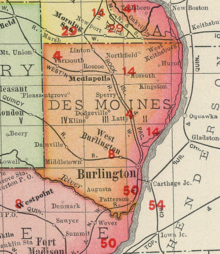
| County | Des Moines |
| Time zone | UTC-6 (Central (CST)) |
| • Summer (DST) | UTC-5 (CDT) |
| Area code(s) | 319 |

Augusta is an unincorporated community situated on the Skunk River in Des Moines County, Iowa, United States. It is located 10 miles southwest of Burlington and nine miles north of Fort Madison, off U.S. Route 61 and Iowa Highway 16. The community is part of the Burlington, IA–IL Micropolitan Statistical Area.
History[]
In 1835, Levi Moffitt, one of the first settlers, built the first water-power "flouring" mill in the state of Iowa. In 1842, Moffitt and Dan Jones built a church in Augusta, and helped to transport immigrants up the river to Nauvoo. The means of travel was a small steamboat that was called the Maid of Iowa, which was captained by Dan Jones.[citation needed]
The Augusta Academy, a co-educational institution, was established in Augusta in January 1839. This was followed by the Augusta Literary and Debating Society, founded in 1879.[1]
The first postmaster of Augusta was Joshua Holland, appointed on October 2, 1846.[1]
Augusta's population was 163 in 1902,[2] and 110 in 1925.[3]
References[]
- ^ Jump up to: a b The History of Des Moines County, Iowa: Containing a History of the County, Its Cities, Towns, &c, a Biographical Directory of Citizens, War Record of Its Volunteers ... General and Local Statistics ... History of the Northwest, History of Iowa, Map of Des Moines County ... Western historical Company. 1879. pp. 543, 597.
- ^ Cram's Modern Atlas: The New Unrivaled New Census Edition. J. R. Gray & Company. 1902. pp. 203–207.
- ^ Company, Rand McNally and (1925). Premier Atlas of the World: Containing Maps of All Countries of the World, with the Most Recent Boundary Decisions, and Maps of All the States,territories, and Possessions of the United States with Population Figures from the Latest Official Census Reports, Also Data of Interest Concerning International and Domestic Political Questions. Rand McNally & Company. p. 190.
| hide Municipalities and communities of Des Moines County, Iowa, United States | ||
|---|---|---|
| Cities | ||
| Townships | ||
| CDPs | ||
| Other community | ||
| ||
This article about the geography of Des Moines County, Iowa is a stub. You can help Wikipedia by . |
- Unincorporated communities in Iowa
- Unincorporated communities in Des Moines County, Iowa
- Burlington, Iowa micropolitan area
- Southeast Iowa geography stubs