Dodgeville, Iowa
Dodgeville, Iowa | |
|---|---|
 Dodgeville, Iowa | |
| Coordinates: 40°56′35″N 91°10′51″W / 40.94306°N 91.18083°WCoordinates: 40°56′35″N 91°10′51″W / 40.94306°N 91.18083°W | |
| Country | United States |
| State | Iowa |
| County | Des Moines |
| Elevation | 738 ft (225 m) |
| Time zone | UTC-6 (Central (CST)) |
| • Summer (DST) | UTC-5 (CDT) |
| Area code(s) | 319 |
| GNIS feature ID | 455937[1] |

Dodgeville is an unincorporated community, in Des Moines County, Iowa, United States.[1]
History[]
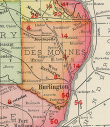
Dodgeville in Des Moines County Iowa, in 1903
Founded in the 1800s, Dodgeville's population was just 17 in 1902,[2] but had increased to 115 by 1925.[3]
Notable person[]
- William F. Kopp, Iowa politician, was born on a farm near Dodgeville.[4]
Notes[]
- ^ a b "Dodgeville, Iowa". Geographic Names Information System. United States Geological Survey.
- ^ Cram's Modern Atlas: The New Unrivaled New Census Edition. J. R. Gray & Company. 1902. pp. 203–207.
- ^ Company, Rand McNally and (1925). Premier Atlas of the World: Containing Maps of All Countries of the World, with the Most Recent Boundary Decisions, and Maps of All the States,territories, and Possessions of the United States with Population Figures from the Latest Official Census Reports, Also Data of Interest Concerning International and Domestic Political Questions. Rand McNally & Company. p. 190.
- ^ William F. Kopp-Iowa General Assembly
Municipalities and communities of Des Moines County, Iowa, United States | ||
|---|---|---|
| Cities | ||
| Townships | ||
| CDPs | ||
| Other community | ||
| ||
This article about the geography of Des Moines County, Iowa is a stub. You can help Wikipedia by . |
Categories:
- Unincorporated communities in Des Moines County, Iowa
- Unincorporated communities in Iowa
- Southeast Iowa geography stubs