Augusta, Maine
Augusta, Maine | |
|---|---|
 Kennebec River flowing past Downtown Augusta | |
 Flag  Seal | |
| Motto(s): "A Capital Opportunity"[1] | |
 Location in Kennebec County in Maine | |
 Augusta, Maine Location in the United States | |
| Coordinates: 44°18′38″N 69°46′46″W / 44.31056°N 69.77944°W | |
| Country | |
| State | |
| County | Kennebec |
| Settled | 1754 |
| Incorporated (town) | February 20, 1797 |
| Incorporated (city) | August 20, 1849 |
| Village | North Augusta |
| Government | |
| • Mayor | David Rollins[2] |
| Area | |
| • Total | 58.04 sq mi (150.31 km2) |
| • Land | 55.15 sq mi (142.83 km2) |
| • Water | 2.89 sq mi (7.48 km2) 5.00% |
| Elevation | 68 ft (20 m) |
| Population (2010) | |
| • Total | 19,136 |
| • Estimate (2019)[4] | 18,697 |
| • Density | 339.04/sq mi (130.90/km2) |
| Time zone | UTC−5 (Eastern) |
| • Summer (DST) | UTC−4 (Eastern) |
| ZIP Codes | 04330, 04332-04333, 04336, 04338 |
| Area code(s) | 207 |
| FIPS code | 23-02100 |
| GNIS feature ID | 581636 |
| Website | City of Augusta, Maine |


Augusta is the state capital of the U.S. state of Maine and the county seat of Kennebec County.[5]
The city's population was 19,136 at the 2010 census, making it the third-least populous state capital in the United States after Montpelier, Vermont, and Pierre, South Dakota, and the ninth-most populous city in Maine. Located on the Kennebec River at the head of tide, Augusta is home to the University of Maine at Augusta. Augusta is also the principal city in the Augusta-Waterville Micropolitan Statistical Area.
History[]
The area was first explored by the ill-fated Popham Colony in September 1607. It was first inhabited by English settlers from the Plymouth Colony in 1628 as a trading post on the Kennebec River. The settlement was known by its Native American name — Cushnoc (or Coussinoc or Koussinoc), meaning "head of the tide." Fur trading was at first profitable, but with Native uprisings and declining revenues, the Plymouth Colony sold the Kennebec Patent in 1661. Cushnoc would remain unoccupied for the next 75 years.[6] This area was inhabited by the Kennebec Natives, a band of the larger Abenaki tribe. During the 17th century, they were on friendly terms with the English settlers in the region.[7][8]
A hotbed of Abenaki hostility toward British settlements was located further up the Kennebec at Norridgewock. In 1722, the tribe and its allies attacked Fort Richmond (now Richmond) and destroyed Brunswick. In response, Norridgewock was sacked in 1724 during Dummer's War, when English forces gained tentative control of the Kennebec. During the height of the French and Indian War, a blockhouse named Fort Western (now the oldest wooden fort in America), was built at Cushnoc on the eastern bank of the Kennebec River in 1754. It was intended as a supply depot for Fort Halifax upriver, as well as to protect its own region from French attack.[9] Later, during the American Revolutionary War Benedict Arnold and his 1,100 troops would use Fort Western as a staging area before continuing their journey up the Kennebec to the Battle of Quebec.
Cushnoc was incorporated as part of Hallowell in 1771. Known as "the Fort," it was set off and incorporated by the Massachusetts General Court in February 1797 as Harrington. In August, however, the name changed to Augusta after Augusta Dearborn, daughter of Henry Dearborn. In 1799, it became county seat for newly created Kennebec County.[9] Maine became a state in 1820 and Augusta was designated its capital in 1827 over rival cities Portland, Brunswick and Hallowell. The Maine State Legislature continued meeting in Portland, however, until completion in 1832 of the new Maine State House designed by Charles Bulfinch. Augusta was ranked as a city in 1849.[10] After being named the state capital and the introduction of new industry, the city flourished. In 1840 and 1850, the city ranked among the 100 largest urban populations. The next decade, however, the city was quickly bypassed by rapidly growing metropolises in the Midwest.[11]
Excellent soil provided for agriculture, and water power from streams provided for the industry. In 1837, a dam was built across the Kennebec where the falls drop 15 feet at the head of a tide. By 1838, 10 sawmills were contracted. With the arrival of the Kennebec & Portland Railroad in 1851, Augusta became an even more productive mill town. In 1883, the property of A. & W. Sprague Company was purchased by the Edwards Manufacturing Company, which erected extensive brick mills for manufacturing cotton textiles. In the late 19th century, a paper and pulp plant was constructed.[12] Other Augusta firms produced lumber, sash, doors, window shutters, broom handles, stone cutters' tools, shoes, headstones, ice and furniture. The city developed as a publishing and shipping center. Today, government and post-secondary education are important businesses.[13]
Since the mid-eighteenth century, there has been a military presence in Augusta. Fort Western has not had troops garrisoned there since the 1790s, but in 1828, the U.S. Government built an arsenal to protect their interests from Britain. During the Civil War, Augusta was a rendezvous point for soldiers traveling to the front. Many of the soldiers camped on the green in front of the capitol building. In 1862, Camp E.D. Keyes was established in the northwestern portion of the city. During World War I, Camp Keyes was used as a mobilization and training camp for soldiers. The camp eventually became a headquarters for the Maine National Guard. In 1929, the state legislature approved the placement of the Augusta State Airport next to the camp. As the airport grew, the use of the camp as a training facility was no longer possible. Today, it is still used for administrative and logistical purposes by the National Guard.
In the 19th century, Augusta got a regular steamboat service and the railroad. The city installed gas lights in 1859. A telephone service was available in 1880 and a local hospital in 1898. In the early 20th century, Augusta built two movie houses and a film production studio.
Downtown revitalization[]
For much of Augusta's history, the central business district was on and near Water Street on the west bank of the Kennebec River. The street, laid out in the late 1700s, was the location of the area's commercial and industrial life. Many fires damaged this concentrated area, including one in 1865 that destroyed nearly 100 buildings. In 1890, the first trolley line began operation down Water Street, connecting Augusta with Gardiner and Hallowell to the south. In 1932, buses replaced the trolley line. With the completion of the Maine Turnpike and Interstate 95 in 1955, local commercial developments began to move away from Water Street and closer to the highway. Among the results was a storefront vacancy rate downtown of about 60 percent.[14]
Since the late 2000s, there has been a renewed and ongoing focus by city officials, the Augusta Downtown Alliance, and private developers to revitalize the downtown area.
Gallery[]


Geography[]
Augusta is located at 44°18′26″N 69°46′54″W / 44.30722°N 69.78167°W,[15] making it the easternmost state capital in the United States. According to the United States Census Bureau, the city has a total area of 58.03 square miles (150.30 km2), of which 55.13 square miles (142.79 km2) is land and 2.90 square miles (7.51 km2) is water.[16] Augusta is drained by Bond's Brook, Woromontogus Stream and the Kennebec River.
Roads[]
The city is crossed by Interstate 95, U.S. Route 201, State Route 11, U.S. Route 202, State Route 9, State Route 3, State Route 100, State Route 27, State Route 8, State Route 104, and State Route 105.
Bordering[]
Augusta borders the towns of Manchester to its west, Sidney and Vassalboro to its north, Windsor to its east, Chelsea to its south, and the city of Hallowell to its southwest.
Climate[]
Augusta's climate is classified as a humid continental climate (Köppen: Dfb). Summers are typically warm, rainy, and humid, while winters are cold, windy, and snowy. Spring and fall are usually mild, but conditions are widely varied, depending on wind direction and jet stream positioning. The hottest month is July, with an average high temperature of 80 °F (26.7 °C). The coldest month is January, with an average low of 10 °F (−12.2 °C). Most snowfall occurs from December through March. There is usually little or no snow in April and November, and snow is rare in May and October.[17]
| hideClimate data for Augusta, Maine (Augusta State Airport), 1991–2020 normals, extremes 1948–present | |||||||||||||
|---|---|---|---|---|---|---|---|---|---|---|---|---|---|
| Month | Jan | Feb | Mar | Apr | May | Jun | Jul | Aug | Sep | Oct | Nov | Dec | Year |
| Record high °F (°C) | 61 (16) |
60 (16) |
85 (29) |
90 (32) |
94 (34) |
98 (37) |
99 (37) |
100 (38) |
96 (36) |
85 (29) |
74 (23) |
67 (19) |
100 (38) |
| Average high °F (°C) | 28.8 (−1.8) |
31.9 (−0.1) |
40.6 (4.8) |
53.5 (11.9) |
65.8 (18.8) |
74.4 (23.6) |
79.9 (26.6) |
78.9 (26.1) |
70.9 (21.6) |
57.9 (14.4) |
45.7 (7.6) |
34.7 (1.5) |
55.2 (12.9) |
| Daily mean °F (°C) | 20.4 (−6.4) |
23.2 (−4.9) |
32.0 (0.0) |
43.8 (6.6) |
55.3 (12.9) |
64.2 (17.9) |
70.1 (21.2) |
68.9 (20.5) |
61.0 (16.1) |
49.2 (9.6) |
38.0 (3.3) |
27.2 (−2.7) |
46.1 (7.8) |
| Average low °F (°C) | 12.1 (−11.1) |
14.4 (−9.8) |
23.4 (−4.8) |
34.2 (1.2) |
44.7 (7.1) |
54.1 (12.3) |
60.3 (15.7) |
58.8 (14.9) |
51.0 (10.6) |
40.4 (4.7) |
30.3 (−0.9) |
19.8 (−6.8) |
37.0 (2.8) |
| Record low °F (°C) | −22 (−30) |
−23 (−31) |
−11 (−24) |
9 (−13) |
26 (−3) |
36 (2) |
43 (6) |
39 (4) |
28 (−2) |
21 (−6) |
4 (−16) |
−15 (−26) |
−23 (−31) |
| Average precipitation inches (mm) | 2.62 (67) |
2.32 (59) |
3.21 (82) |
3.82 (97) |
3.27 (83) |
4.01 (102) |
3.20 (81) |
3.41 (87) |
3.90 (99) |
4.69 (119) |
3.95 (100) |
3.44 (87) |
41.84 (1,063) |
| Average snowfall inches (cm) | 19.0 (48) |
14.8 (38) |
15.2 (39) |
4.5 (11) |
0.0 (0.0) |
0.0 (0.0) |
0.0 (0.0) |
0.0 (0.0) |
0.0 (0.0) |
0.3 (0.76) |
3.6 (9.1) |
13.9 (35) |
71.3 (181) |
| Average precipitation days (≥ 0.01 in) | 10.1 | 9.5 | 11.0 | 11.9 | 13.1 | 12.7 | 12.2 | 10.7 | 10.2 | 12.3 | 11.3 | 12.3 | 137.3 |
| Average snowy days (≥ 0.1 in) | 8.7 | 6.9 | 6.1 | 1.9 | 0.0 | 0.0 | 0.0 | 0.0 | 0.0 | 0.3 | 2.8 | 6.9 | 33.6 |
| Source: NOAA (snow 1981–2010)[18][19][20] | |||||||||||||
Demographics[]
| Historical population | |||
|---|---|---|---|
| Census | Pop. | %± | |
| 1800 | 1,211 | — | |
| 1810 | 1,805 | 49.1% | |
| 1820 | 2,457 | 36.1% | |
| 1830 | 3,980 | 62.0% | |
| 1840 | 5,314 | 33.5% | |
| 1850 | 8,225 | 54.8% | |
| 1860 | 7,609 | −7.5% | |
| 1870 | 7,808 | 2.6% | |
| 1880 | 8,665 | 11.0% | |
| 1890 | 10,527 | 21.5% | |
| 1900 | 11,683 | 11.0% | |
| 1910 | 13,211 | 13.1% | |
| 1920 | 14,114 | 6.8% | |
| 1930 | 17,198 | 21.9% | |
| 1940 | 19,360 | 12.6% | |
| 1950 | 20,913 | 8.0% | |
| 1960 | 21,680 | 3.7% | |
| 1970 | 21,945 | 1.2% | |
| 1980 | 21,819 | −0.6% | |
| 1990 | 21,325 | −2.3% | |
| 2000 | 18,560 | −13.0% | |
| 2010 | 19,136 | 3.1% | |
| 2019 (est.) | 18,697 | [4] | −2.3% |
| U.S. Decennial Census[21] | |||
2010 census[]
As of the census[22] of 2010, there were 19,136 people, 8,802 households, and 4,490 families residing in the city. The population density was 347.1 inhabitants per square mile (134.0/km2). There were 9,756 housing units at an average density of 177.0 per square mile (68.3/km2). The racial makeup of the city was 94.1% White, 1.1% African American, 0.7% Native American, 1.5% Asian, 0.1% Pacific Islander, 0.4% from other races, and 2.3% from two or more races. Hispanic or Latino of any race were 1.8% of the population.
There were 8,802 households, of which 23.0% had children under the age of 18 living with them, 35.2% were married couples living together, 11.8% had a female householder with no husband present, 4.0% had a male householder with no wife present, and 49.0% were non-families. 39.8% of all households were made up of individuals, and 13.6% had someone living alone who was 65 years of age or older. The average household size was 2.08 and the average family size was 2.76.
The median age in the city was 43.2 years. 18.3% of residents were under the age of 18; 8.1% were between the ages of 18 and 24; 26% were from 25 to 44; 29.4% were from 45 to 64; and 18% were 65 years of age or older. The gender makeup of the city was 48.6% male and 51.4% female.
2000 census[]
As of the census[23] of 2000, there were 18,560 people, 8,565 households, and 4,607 families residing in the city. The population density was 335.1 people per square mile (129.4/km2). There were 9,480 housing units at an average density of 171.2 per square mile (66.1/km2). The racial makeup of the city was 96.21% White, 0.50% Black or African American, 0.48% Native American, 1.35% Asian, 0.01% Pacific Islander, 0.16% from other races, and 1.3% from two or more races. 0.86% of the population were Hispanic or Latino of any race.
There were 8,565 households, out of which 24.3% had children under the age of 18 living with them, 39.1% were married couples living together, 10.9% had a female householder with no husband present, and 46.2% were non-families. 38.3% of all households were made up of individuals, and 14.2% had someone living alone who was 65 years of age or older. The average household size was 2.10 and the average family size was 2.77.
In the city, the population was spread out, with 20.5% under the age of 18, 8.7% from 18 to 24, 28.3% from 25 to 44, 24.8% from 45 to 64, and 17.7% who were 65 years of age or older. The median age was 40 years. For every 100 females, there were 89.9 males. For every 100 females age 18 and over, there were 87.5 males.
The median income for a household in the city was $29,921, and the median income for a family was $42,230. Males had a median income of $31,209 versus $22,548 for females. The per capita income for the city was $19,145. About 11.4% of families and 15.0% of the population were below the poverty line, including 19.2% of those under age 18 and 9.8% of those age 65 or over.
Government[]
Local government[]
Augusta is governed by a mayor and council-manager system. The City Council oversees all City government activities and establishes the legislative policies of the city, adopts and amends ordinances and local laws, appropriates municipal resources, and sets the tax rate. The City Manager serves as the chief executive officer and purchasing agent of the city. The mayor presides at all meetings of the council, and is recognized ceremonially as the official head of the city.
The city maintains a police department remarkable for having not had an officer killed in the line of duty for over a century.[24]
Political makeup[]
Augusta has historically been Democratic. In the 2012 presidential election, Barack Obama received 5,192 of the votes to Mitt Romney's 3,339.[25] In the 2020 presidential election, Joe Biden won 5,248 votes to Donald Trump's 4,155. [26]
The city has not voted for a Republican presidential candidate since the Republican landslide of 1988. Democrats are the majority political affiliation in all four voting wards, and there are more unenrolled voters than Republicans in the City.
- Voter registration
| Voter Registration and Party Enrollment as of November 2012[27] | |||||
|---|---|---|---|---|---|
| Party | Total Voters | Percentage | |||
| Democratic | 4,780 | 34.82% | |||
| Unenrolled | 4,778 | 34.80% | |||
| Republican | 3,656 | 26.63% | |||
| Green Independent | 512 | 3.70% | |||
| Total | 13,726 | 100% | |||
Education[]
There are five public schools, one private school, one college (the University of Maine at Augusta),[28] and two public libraries in Augusta. Farrington, Gilbert, Hussey, and Lincoln are the four public elementary schools that are spread throughout[vague] the city.[29] Cony is the public school serving students in grades 7-12 from Augusta and the surrounding towns; Cony comprises Cony High School and Cony Middle School.[30] St. Michaels is the private Catholic school that children from Augusta and surround towns may attend for tuition.[31] The University of Maine at Augusta is third largest university in the University of Maine System.[32] The Maine State Library[33] and Lithgow Public Library[34] are both located in Augusta.
Media[]
Printed media[]
- Kennebec Journal, daily newspaper for capitol area
- Uncle Henry's, weekly classified adverts publication
Radio[]
Television[]
Augusta is part of the Portland television market, and receives most of that market's channels. WCBB channel 10, licensed to Augusta, is the local television outlet for the Maine Public Broadcasting Network. [35]
Transportation[]
Interstate 95 runs by the western outskirts of Augusta. U.S. 202 runs east-west through the city. U.S. 201 runs north-south through the city.
Augusta State Airport in the western part of the city has commercial flights.
Sites of interest[]
- Blaine House
- Fort Western
- [36] at the University of Maine at Augusta
- Lithgow Public Library
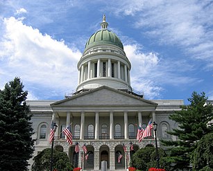
- Maine State House
- Maine State Museum[37]
- Viles Arboretum
Notable people[]

- Ambrose Abbott, state legislator
- Martha Ballard, midwife
- James G. Blaine, Secretary of State and presidential nominee
- Horatio Bridge, navy officer
- Julia Clukey, 2010 Olympic luger[38][39]
- Beverly Daggett, President of the Maine Senate
- Olive E. Dana, short-story writer, essayist, poet
- Melville Fuller, Chief Justice of the United States Supreme Court
- George Huntington Hartford, owned the Great Atlantic and Pacific Tea Company, the country's largest food retailer at the time of his death[40]
- John F. Hill, former Maine governor
- Robert Deniston Hume, Oregon politician and businessman
- Eastman Johnson, artist
- Roger Katz, mayor of Augusta and state legislator
- George W. Ladd, U.S. congressman
- Dorianne Laux, poet
- Sumner Lipman, state legislator and attorney
- Ben Lucas, football player
- Henry A. McMasters, recipient of the Medal of Honor[41]
- Rachel Nichols, actress
- Frederick G. Payne, Mayor of Augusta and 60th governor of Maine
- David Peoples, athlete and golfer
- Frederick W. Plaisted, mayor of Augusta, 48th governor of Maine
- John F. Potter, U.S. congressman, judge
- Travis Roy, hockey player
- Luther Severance, publisher, U.S. congressman and senator
- Olympia Snowe, U.S. senator
- John L. Stevens, U.S. minister to Kingdom of Hawaii, accused of attempting to overthrow Hawaiian queen, 1893
- Manch Wheeler, quarterback with the Buffalo Bills
- Gil Whitney, television news anchorman and meteorologist
- Reuel Williams, U.S. senator
- Willard G. Wyman, general
References[]
- ^ "City of Augusta, Maine". City of Augusta, Maine. Archived from the original on August 29, 2012. Retrieved August 26, 2012.
- ^ "Rollins wins Augusta mayor race". Kennebec Journal. Archived from the original on November 5, 2014. Retrieved November 5, 2014.
- ^ "2019 U.S. Gazetteer Files". United States Census Bureau. Retrieved July 25, 2020.
- ^ Jump up to: a b "Population and Housing Unit Estimates". United States Census Bureau. May 24, 2020. Retrieved May 27, 2020.
- ^ Population and Population Centers by State Archived December 12, 2001, at the Wayback Machine
- ^ "The Forgotten Inhabitants of Cushnoc". Archived from the original on November 16, 2007. Retrieved September 25, 2007.
- ^ The History of Augusta, from the Earliest Settlement to the Present Time ... By James W. North page 4
- ^ North, James W. (1870). "The History of Augusta, from the Earliest Settlement to the Present Time: With Notices of the Plymouth Company, and Settlements on the Kennebec; Together with Biographical Sketches and Genealogical Register".
- ^ Jump up to: a b Maine League of Historical Societies and Museums (1970). Doris A. Isaacson (ed.). Maine: A Guide 'Down East'. Rockland, Me: Courier-Gazette, Inc. pp. 148–152.
- ^ Coolidge, Austin J.; John B. Mansfield (1859). A History and Description of New England. Boston, Massachusetts: A.J. Coolidge. pp. 38–42. Retrieved November 21, 2015.
coolidge mansfield history description new england 1859.
- ^ "Archived copy". Archived from the original on January 2, 2011. Retrieved December 7, 2017.CS1 maint: archived copy as title (link)
- ^ "Archived copy". Archived from the original on March 4, 2016. Retrieved April 23, 2011.CS1 maint: archived copy as title (link)
- ^ Varney, George J. (1886), Gazetteer of the state of Maine. Augusta, Boston: Russell, retrieved March 30, 2006
- ^ "Archived copy". Archived from the original on August 29, 2018. Retrieved August 28, 2018.CS1 maint: archived copy as title (link)
- ^ "US Gazetteer files: 2010, 2000, and 1990". United States Census Bureau. February 12, 2011. Retrieved April 23, 2011.
- ^ "US Gazetteer files 2010". United States Census Bureau. Archived from the original on February 20, 2011. Retrieved November 23, 2012.
- ^ "May in the Northeast". Intellicast.com. 2003. Archived from the original on April 29, 2007. Retrieved April 29, 2007.
- ^ "NowData – NOAA Online Weather Data". National Oceanic and Atmospheric Administration. Retrieved May 20, 2021.
- ^ "Station: Augusta State AP, ME". U.S. Climate Normals 2020: U.S. Monthly Climate Normals (1991-2020). National Oceanic and Atmospheric Administration. Retrieved May 20, 2021.
- ^ "Station: Augusta State AP, ME". U.S. Monthly Climate Normals (1981-2010). National Oceanic and Atmospheric Administration. Retrieved May 20, 2021.
- ^ "Census of Population and Housing". Census.gov. Retrieved June 4, 2015.
- ^ "U.S. Census website". United States Census Bureau. Retrieved November 23, 2012.
- ^ "U.S. Census website". United States Census Bureau. Retrieved January 31, 2008.
- ^ The Daily Caller, American arms race heats up at local police level, May 7, 2012
- ^ "Archived copy". Archived from the original on September 15, 2013. Retrieved November 13, 2012.CS1 maint: archived copy as title (link)
- ^ https://cms6.revize.com/revize/augustame/Official%20State%20and%20City%20ROVC%20November%2003%202020%20Signed.pdf
- ^ "REGISTERED & ENROLLED VOTERS - STATEWIDE" (PDF). November 6, 2012. Archived from the original (PDF) on December 11, 2012. Retrieved March 23, 2013.
- ^ "University of Maine at Augusta". Archived from the original on June 30, 2006. Retrieved September 26, 2007.
- ^ "City of Augusta, Maine School Department". Archived from the original on January 13, 2016. Retrieved September 7, 2015.
- ^ "Cony". Archived from the original on January 12, 2016. Retrieved September 7, 2015.
- ^ "St. Michael School". Archived from the original on June 30, 2015. Retrieved September 7, 2015.
- ^ "UMA Quick Facts". Archived from the original on September 5, 2015. Retrieved September 7, 2015.
- ^ "Maine State Library". Archived from the original on August 28, 2015. Retrieved September 7, 2015.
- ^ "Lithgow Public Library". Archived from the original on October 3, 2015. Retrieved September 25, 2007.
- ^ "WCBB Channel 10". Archived from the original on October 1, 2015. Retrieved October 1, 2015.
- ^ "HHRC Website". Archived from the original on November 5, 2019. Retrieved November 27, 2019.
- ^ Maine State Museum Archived December 26, 2007, at the Wayback Machine
- ^ "Julia Clukey". Archived from the original on November 7, 2017. Retrieved September 16, 2015.
- ^ Clark, Ernie. "Augusta's Julia Clukey looks to the future after Olympic luge near-miss". Bangor Daily News. Archived from the original on September 11, 2016. Retrieved September 16, 2015.
- ^ Levinson, Marc (2011). The Great A&P and the struggle for small business in America. Hill and Wang. ISBN 978-0-8090-9543-8.
- ^ "Medal of Honor recipients". United States Army. Archived from the original on November 10, 2010. Retrieved November 19, 2010.
External links[]
| Wikimedia Commons has media related to Augusta, Maine. |
| Wikivoyage has a travel guide for Augusta, Maine. |
| Wikisource has the text of a 1911 Encyclopædia Britannica article about Augusta, Maine. |
- City of Augusta, Maine
- Lithgow Public Library
- University of Maine at Augusta
- City Data Profile
- Epodunk City Profile
- . The American Cyclopædia. 1879.
Coordinates: 44°18′25″N 69°46′55″W / 44.307°N 69.782°W
| show Municipalities and communities of Kennebec County, Maine, United States |
|---|

| show |
|---|

| show New England |
|---|
| show Authority control |
|---|
- Augusta, Maine
- Cities in Maine
- Cities in Kennebec County, Maine
- County seats in Maine
- Populated places established in 1629
- 1629 establishments in the Thirteen Colonies