Bütow
Bütow | |
|---|---|
show Location of Bütow within Mecklenburgische Seenplatte district | |
 Bütow | |
| Coordinates: 53°21′0″N 12°28′59″E / 53.35000°N 12.48306°ECoordinates: 53°21′0″N 12°28′59″E / 53.35000°N 12.48306°E | |
| Country | Germany |
| State | Mecklenburg-Vorpommern |
| District | Mecklenburgische Seenplatte |
| Municipal assoc. | Röbel-Müritz |
| Government | |
| • Mayor | Siegfried Haustein |
| Area | |
| • Total | 26.32 km2 (10.16 sq mi) |
| Elevation | 78 m (256 ft) |
| Population (2020-12-31)[1] | |
| • Total | 458 |
| • Density | 17/km2 (45/sq mi) |
| Time zone | UTC+01:00 (CET) |
| • Summer (DST) | UTC+02:00 (CEST) |
| Postal codes | 17209 |
| Dialling codes | 039922 |
| Vehicle registration | MÜR |
| Website | www |
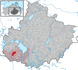


Bütow is a municipality in the Mecklenburgische Seenplatte district, in Mecklenburg-Vorpommern, Germany.
Geography[]
Bütow is located in the Mecklenburg Lake Plateau, to the east of the source of the Elde river. It is a hilly area, with the highest point 101 m (331 ft) above sea level.
- Church ruin in Bütow-Dambeck

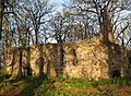
Nave

Choir

Gable
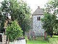
Village church in Bütow.


Transportation[]
Bütow is located about two kilometers away from the federal highway B 198. The Autobahn 19 Berlin - Rostock is about three kilometers away. The nearest railway station is located in Malchow.
References[]
- ^ "Statistisches Amt M-V – Bevölkerungsstand der Kreise, Ämter und Gemeinden 2020". Statistisches Amt Mecklenburg-Vorpommern (in German). July 2021.
External links[]
![]() Media related to Bütow at Wikimedia Commons
Media related to Bütow at Wikimedia Commons
| show Towns and municipalities in Mecklenburgische Seenplatte |
|---|
| show Authority control |
|---|
This Mecklenburgische Seenplatte (district) location article is a stub. You can help Wikipedia by . |
Categories:
- Municipalities in Mecklenburg-Vorpommern
- Bezirk Neubrandenburg
- Mecklenburgische Seenplatte (district) geography stubs