Stuer, Mecklenburg-Vorpommern
Stuer, Mecklenburg-Vorpommern | |
|---|---|
![Ruins of Burg Stuer [de]](http://upload.wikimedia.org/wikipedia/commons/thumb/1/12/Burg-stuer2007-07.jpg/250px-Burg-stuer2007-07.jpg) Ruins of | |
 Coat of arms | |
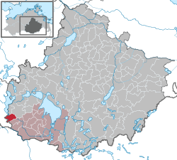
show Location of Stuer, Mecklenburg-Vorpommern within Mecklenburgische Seenplatte district | |
 Stuer, Mecklenburg-Vorpommern | |
| Coordinates: 53°22′59″N 12°19′59″E / 53.38306°N 12.33306°ECoordinates: 53°22′59″N 12°19′59″E / 53.38306°N 12.33306°E | |
| Country | Germany |
| State | Mecklenburg-Vorpommern |
| District | Mecklenburgische Seenplatte |
| Municipal assoc. | Röbel-Müritz |
| Government | |
| • Mayor | Gundolf Otto |
| Area | |
| • Total | 21.53 km2 (8.31 sq mi) |
| Elevation | 87 m (285 ft) |
| Population (2020-12-31)[1] | |
| • Total | 247 |
| • Density | 11/km2 (30/sq mi) |
| Time zone | UTC+01:00 (CET) |
| • Summer (DST) | UTC+02:00 (CEST) |
| Postal codes | 17209 |
| Dialling codes | 039924 |
| Vehicle registration | MÜR |
| Website | www.amt-roebel-mueritz.de |


Stuer is a municipality in the Mecklenburgische Seenplatte district, in Mecklenburg-Vorpommern, Germany.
References[]
- ^ "Statistisches Amt M-V – Bevölkerungsstand der Kreise, Ämter und Gemeinden 2020". Statistisches Amt Mecklenburg-Vorpommern (in German). July 2021.
| show Towns and municipalities in Mecklenburgische Seenplatte |
|---|
| Authority control |
|---|
This Mecklenburgische Seenplatte (district) location article is a stub. You can help Wikipedia by . |
Categories:
- Municipalities in Mecklenburg-Vorpommern
- Bezirk Neubrandenburg
- Mecklenburgische Seenplatte (district) geography stubs