Bab Huta


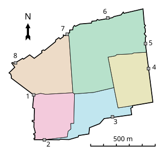
Bab Ḥuṭa is a neighborhood in the Muslim Quarter of the Old City of Jerusalem to the north of the Haram al-Sharif (Temple Mount). It is named after the gate in the Haram compound which is Arabic for "Forgiveness Gate".
History[]
In the late 15th century, Mujir ad-Din described it as one of the largest quarters in Jerusalem.[1] A census taken by the Ottoman authority registered only Muslims in the quarter.[1] At the beginning of the 20th century, the quarter had boundaries defined as follows:
- North and East - the city walls between St Stephen's Gate and Herod's Gate.
- South - the north side of the Temple Mount.
- West - Zawiyat el-Hunud Street, 'Aqabet er-Rahibat, Bab el-Ghawanima Street.[1]
Around the end of the 19th century, Jews were a majority of Jerusalem's population, and began to spread out of the Jewish Quarter into the Muslim Quarter, including Bab al-Huta.[citation needed]
Demographics[]
The neighborhood is considered one of the poorest areas in the Old City. It is home to the Dom Romani community of the Old City, known in Arabic as al-Nawar, led by mukhtar Abed-Alhakim Mohammed Deeb Salim.[2][3][4][5]
References[]
- ^ Jump up to: a b c Adar Arnon (1992). "The Quarters of Jerusalem in the Ottoman Period". Middle Eastern Studies. 28 (1): 1–65.
- ^ Selig, Abe. Jerusalem’s Herod’s Gate receives face-lift. 06/29/2010. Jerusalem Post
- ^ A People Apart: The Romani community seeks recognition. By Eetta Prince-Gibson. Dom Research Center. 2001
- ^ Danny Rubinstein. People / Steve Sabella: Blurring the lines. Haaretz. 2005
- ^ Joseph B. Glass and Rassem Khamaisi. Report on the Socio-Economic Conditions in the Old City of Jerusalem. Munk Centre for International Studies, University of Toronto. p.4
Coordinates: 31°46′55″N 35°14′07″E / 31.78194°N 35.23528°E
- Neighbourhoods of Jerusalem
- Arab neighborhoods in Jerusalem
- Nawar people
- Romani communities in Asia
- Romani in Israel
- Romani in the State of Palestine


