Babase Island
| Babase | |
|---|---|
 Feni Islands seen from space, with Ambitle (left) and Babase (right). | |
| Highest point | |
| Elevation | 200 m (660 ft) |
| Prominence | 200 m (660 ft) |
| Coordinates | 4°2′S 153°43′E / 4.033°S 153.717°E |
| Geography | |
| Location | Bismarck Archipelago, Papua New Guinea |
| Geology | |
| Mountain type | Stratovolcano |
| Last eruption | Unknown |

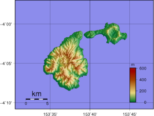
Babase Island is an island of the Feni Islands in Papua New Guinea, located east of New Ireland. It consists of a stratovolcano and a lava dome, joined by an isthmus.
References[]
This New Ireland Province geography article is a stub. You can help Wikipedia by . |
Categories:
- Islands of Papua New Guinea
- Stratovolcanoes of Papua New Guinea
- New Ireland Province
- Islands Region geography stubs