Pana Tinani
Nickname: Joannett Island | |
|---|---|
 | |
 Pana Tinani Island | |
| Geography | |
| Location | Oceania= |
| Coordinates | 11°13′48″S 153°09′32″E / 11.23000°S 153.15889°ECoordinates: 11°13′48″S 153°09′32″E / 11.23000°S 153.15889°E[1] |
| Archipelago | Louisiade Archipelago |
| Adjacent bodies of water | Solomon Sea |
| Total islands | 1 |
| Major islands |
|
| Area | 78 km2 (30 sq mi) |
| Length | 19 km (11.8 mi) |
| Width | 6 km (3.7 mi) |
| Highest elevation | 338 m (1109 ft) |
| Highest point | Mount Guyuba |
| Administration | |
| Province | |
| District | Samarai-Murua District |
| LLG[2] | Yaleyamba Rural Local Level Government Area |
| Island Group | Pana Tinani Group |
| Largest settlement | (pop. ~200) |
| Demographics | |
| Population | 740 (2014) |
| Pop. density | 9.5/km2 (24.6/sq mi) |
| Ethnic groups | Papauans, Austronesians, Melanesians. |
| Additional information | |
| Time zone | |
| ISO code | PG-MBA |
| Official website | www |

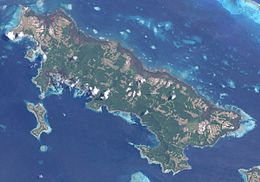
Pana Tinani is an island in the Louisiade Archipelago in Milne Bay Province, Papua New Guinea.
Geography[]
The island has an area of 78 km2, making it the sixth largest island of the Louisiade Archipelago. The island is hilly, rising to 338 m at Mt. Guyuba. The island is 3.1 km north of Vanatinai, and separated from it with the . It is also 100 meters east of , the easternmost island in the Calvados Chain. separated with the .
History[]
The island was discovered in the late 18th century, named after the wife of the explorer Joannett.
Population[]
At the census of population in 2014, the island had 740 inhabitants, spread across 11 villages. The main town is (formerly Hebwaun) on the southeast coast. The island's population is administered by 2 wards : Nimoa Ward, Wanim Ward.
References[]
This article about an island in Papua New Guinea is a stub. You can help Wikipedia by . |
- Islands of Milne Bay Province
- Louisiade Archipelago
- Papua New Guinea island stubs