Bad Tatzmannsdorf
Bad Tatzmannsdorf | |
|---|---|
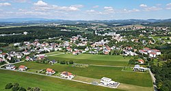 Aerial view of Bad Tatzmannsdorf | |
 Coat of arms | |
 Bad Tatzmannsdorf Location within Austria | |
| Coordinates: 47°20′N 16°14′E / 47.333°N 16.233°ECoordinates: 47°20′N 16°14′E / 47.333°N 16.233°E | |
| Country | Austria |
| State | Burgenland |
| District | Oberwart |
| Government | |
| • Mayor | Gert Polster (SPÖ) |
| Area | |
| • Total | 11.63 km2 (4.49 sq mi) |
| Population (2018-01-01)[2] | |
| • Total | 1,554 |
| • Density | 130/km2 (350/sq mi) |
| Time zone | UTC+1 (CET) |
| • Summer (DST) | UTC+2 (CEST) |
| Postal code | 7431 |
| Website | www.bad-tatzmannsdorf.at |

Bad Tatzmannsdorf (Hungarian: Tarcsafürdő, Croatian: Tarča) is a municipality in Burgenland in the district of Oberwart in Austria.
Geography[]
Parts of the municipality are Bad Tatzmannsdorf, Jormannsdorf, and Sulzriegel.
The countryside is rolling hills ideal for walkers.
In recent years the town is developing its hot water spa facilities which are provided by a number of spa hotels and a public facility called the Burgenland Spa.
History[]
Between 1869 and 1921 Bad Tatzmannsdorf belonged to Hungary, like the whole of Burgenland.
Population[]
| Year | Pop. | ±% |
|---|---|---|
| 1869 | 921 | — |
| 1880 | 977 | +6.1% |
| 1890 | 993 | +1.6% |
| 1900 | 959 | −3.4% |
| 1910 | 861 | −10.2% |
| 1923 | 892 | +3.6% |
| 1934 | 915 | +2.6% |
| 1939 | 901 | −1.5% |
| 1951 | 847 | −6.0% |
| 1961 | 892 | +5.3% |
| 1971 | 1,052 | +17.9% |
| 1981 | 1,092 | +3.8% |
| 1991 | 1,134 | +3.8% |
| 2001 | 1,316 | +16.0% |
| 2011 | 1,369 | +4.0% |
Politics[]
Of the 19 positions on the municipal council, the ÖVP has 8, the SPÖ 7, and the FPÖ 4.
References[]
- ^ "Dauersiedlungsraum der Gemeinden Politischen Bezirke und Bundesländer - Gebietsstand 1.1.2018". Statistics Austria. Retrieved 10 March 2019.
- ^ "Einwohnerzahl 1.1.2018 nach Gemeinden mit Status, Gebietsstand 1.1.2018". Statistics Austria. Retrieved 9 March 2019.
| Wikimedia Commons has media related to Bad Tatzmannsdorf. |
| Authority control |
|---|
This Burgenland location article is a stub. You can help Wikipedia by . |
Categories:
- Spa towns in Austria
- Cities and towns in Oberwart District
- Burgenland geography stubs