Litzelsdorf
Litzelsdorf | |
|---|---|
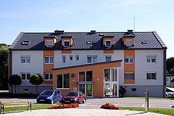 Municipal office | |
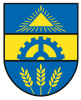 Coat of arms | |
 Litzelsdorf Location within Austria | |
| Coordinates: 47°13′N 16°10′E / 47.217°N 16.167°ECoordinates: 47°13′N 16°10′E / 47.217°N 16.167°E | |
| Country | Austria |
| State | Burgenland |
| District | Oberwart |
| Government | |
| • Mayor | Peter Fassl (ÖVP) |
| Area | |
| • Total | 13.88 km2 (5.36 sq mi) |
| Elevation | 292 m (958 ft) |
| Population (2018-01-01)[2] | |
| • Total | 1,181 |
| • Density | 85/km2 (220/sq mi) |
| Time zone | UTC+1 (CET) |
| • Summer (DST) | UTC+2 (CEST) |
| Postal code | 7532 |
| Website | www.litzelsdorf.at |

Litzelsdorf (Hungarian: Lődös, Croatian: Licištrof) is a town in the district of Oberwart in the Austrian state of Burgenland.
Geography[]
The small town is located in the south of Burgenland.
History[]
The town of Litzelsdorf along with the whole Burgenland belonged to the Western part of the Kingdom of Hungary until 1920/21, and its official name was Lődös. After World War I Burgenland was awarded to the newly formed Republic of Austria as a result of the Treaties of St. Germain and Trianon. Since 1921 Litzelsdorf belongs to the newly formed state of Burgenland.
Population[]
| Year | Pop. | ±% |
|---|---|---|
| 1869 | 1,333 | — |
| 1880 | 1,528 | +14.6% |
| 1890 | 1,729 | +13.2% |
| 1900 | 1,956 | +13.1% |
| 1910 | 1,888 | −3.5% |
| 1923 | 1,709 | −9.5% |
| 1934 | 1,618 | −5.3% |
| 1939 | 1,313 | −18.9% |
| 1951 | 1,259 | −4.1% |
| 1961 | 1,092 | −13.3% |
| 1971 | 1,155 | +5.8% |
| 1981 | 1,151 | −0.3% |
| 1991 | 1,156 | +0.4% |
| 2001 | 1,151 | −0.4% |
| 2011 | 1,144 | −0.6% |
Politics[]
The current mayor of Litzelsdorf is Peter Fassl (Austrian People's Party = ÖVP) and the vice mayor is Martin Gerbafczits (Social Democratic Party of Austria = SPÖ).
Coat of arms[]
The coat of arms is coloured in blue and gold and divided into 3 parts. The first part is blue and shows a golden triangle with rays. This is a symbol for the trinity – and a column has been built a long time ago as a sign of adoring trinity. In the second part, which is colored in gold, a blue gear wheel can be seen and in the last part, coloured in blue ears (botany) can be seen. These are symbols for trade and agriculture. coats of arms
References[]
- ^ "Dauersiedlungsraum der Gemeinden Politischen Bezirke und Bundesländer - Gebietsstand 1.1.2018". Statistics Austria. Retrieved 10 March 2019.
- ^ "Einwohnerzahl 1.1.2018 nach Gemeinden mit Status, Gebietsstand 1.1.2018". Statistics Austria. Retrieved 9 March 2019.
External links[]
| Authority control |
|---|
This Burgenland location article is a stub. You can help Wikipedia by . |
- Cities and towns in Oberwart District
- Burgenland geography stubs