Badakhshan Province
Badakhshan Province
بدخشان | |
|---|---|
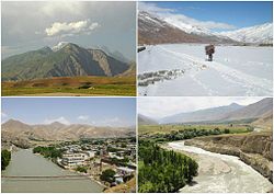 Different districts of Badakhshan Province | |
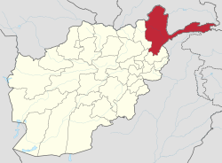 Map of Afghanistan with Badakhshan highlighted | |
| Coordinates: 38°0′N 71°0′E / 38.000°N 71.000°ECoordinates: 38°0′N 71°0′E / 38.000°N 71.000°E | |
| Country | |
| Capital | Fayzabad |
| Government | |
| • Governor | |
| Area | |
| • Total | 44,059 km2 (17,011 sq mi) |
| Population (2021)[2] | |
| • Total | 1,072,785 |
| • Density | 24/km2 (63/sq mi) |
| Time zone | UTC+4:30 (Afghanistan Time) |
| ISO 3166 code | AF-BDS |
| Main languages | Dari, Khowar, Kyrgyz, Shughni, Munji, Ishkashimi, Wakhi, Persian |

Badakhshan Province (Dari/Pashto: بدخشان, Badaxšān) is one of the 34 provinces of Afghanistan, located in the farthest north-eastern part of the country between Tajikistan and Pakistan-administered Gilgit-Baltistan region. It shares a 91-kilometer (57-mile) border with China.
It is part of a broader historical Badakhshan region. The province contains 22 to 28 districts, over 1,200 villages and approximately 1,054,087 people.[3] Fayzabad serves as the provincial capital.
Etymology[]
From Etymology perspective, Badakhshan's name comes from the Middle Persian word "badaxš" which is an official title.The word "ān" is a suffix which demonstrates a place's name; therefore the word "badaxšān" means a place belonging to a person called "badaxš".[4]
During Sassanids reign it was called as "bidix" and in Parthians times as "bthšy". In Sassanid manuscripts found in Ka'ba-ye Zartosht it was called as "Bałasakan".In Chinese sources from 7th century onwards it was called as "Po-to-chang-na".
Geography[]


Badakhshan is bordered by Takhar Province to the west, Panjshir Province to the south west, Nuristan Province to the south, Tajikistan to the north and east (that nation's Gorno-Badakhshan Autonomous Province and Khatlon Province), China through a long spur called the Wakhan Corridor to the east, and Pakistan to the south-east (Chitral and Gilgit-Baltistan). The total area of Badakhshan is 44,059 square kilometres (17,011 sq mi), most of which is occupied by the Hindu Kush and Pamir mountain ranges.
According to the World Wildlife Fund,[citation needed] Badakhshan contains temperate grasslands, savannas, and shrublands, as well as Gissaro-Alai open woodlands along the Pamir River. Common plants found in these areas include pistachio, almond, walnut, apple, juniper, and sagebrush.
Montane grasslands and shrublands are existent in the province, with the Hindu Kush alpine meadow in the high mountains in the northern and southwestern regions.
The Wakhan corridor contains two montane grassland and shrubland regions: the Karakoram-West Tibetan Plateau alpine steppe and in the Pamir Mountains and Kuh-e Safed Khers in Darwaz region.
South of Fayzabad the terrain becomes dominated by deserts and xeric shrublands. Common vegetation includes thorny bushes, zizyphus, acacia, and Amygdatus. Paropamisus xeric woodlands can be found in the province's northwestern and central areas. Common vegetation includes almond, pistachio, willows, and sea-buckthorn.
History[]
| History of Afghanistan |
|---|
 |
| Timeline |
| Related historical names of the region |
|
| Related topics |
|
The Achaemenid Empire conquered the area in the 1st millennium BC. Badakhshan etymologically derives from the Middle Persian word badaxš, an official title. The suffix of the name, -ān, means the region belonged to someone with the title badaxš.[5]
The territory was ruled by the Uzbek Khanate of Bukhara between the early 16th century and the mid-18th century. It was given to Ahmad Shah Durrani by Murad Beg of Bukhara after a treaty of friendship was reached in or about 1750 and became part of the Durrani Empire. It was ruled by the Durranis followed by the Barakzai dynasty, and was untouched by the British during the three Anglo-Afghan Wars that were fought in the 19th and 20th centuries. It remained peaceful for about 100 years until the 1980s Soviet–Afghan War at which point the Mujahideen began a rebellion against the central Afghan government.
During the 1990s, much of the area was controlled by forces loyal to Burhanuddin Rabbani and Ahmad Shah Massoud,[6] who were de facto the national government until 1996. Badakhshan was the only province that the Taliban did not conquer during their rule from 1996 to 2001. However, during the course of the wars a non-Taliban Islamic emirate was established in Badakhshan by Mawlawi Shariqi, paralleling the Islamic Revolutionary State of Afghanistan in neighboring Nuristan. Rabbani, a Badakhshan native, and Massoud were the last remnants of the anti-Taliban Northern Alliance during the peak of Taliban control in 2001.
Badakhshan was thus one of the few provinces of the country that witnessed little insurgency in the Afghan wars – however, during the 2010s Taliban insurgents managed to attack and take control of several districts in the province.[7]
On 26 October 2015, the 7.5 Mw Hindu Kush earthquake shook northern Afghanistan with a maximum Mercalli intensity of VIII (Severe). This earthquake destroyed almost 30,000 homes, left several hundred dead, and more than 1,700 injured.[8]
Transportation[]
Fayzabad Airport serves the province with regular direct flights to Kabul.
Healthcare[]
The percentage of households with clean drinking water increased from 13% in 2005 to 21% in 2011.[9] The percentage of births attended to by a skilled birth attendant increased from 1.5% in 2003 to 2% in 2011.[9]
Education[]
Badakhshan University is located in Fayzabad, a city which also has a number of public schools including an all-girls school.
The overall literacy rate (6+ years of age) fell from 31% in 2005 to 26% in 2011.[9] The overall net enrolment rate (6–13 years of age) increased from 46% in 2005 to 68% in 2011.[9]
Economy[]

Despite massive mineral reserves, Badakhshan is one of the most destitute areas in the world. Opium poppy growing is the only real source of income in the province and Badakhshan has one of the highest rates of maternal mortality in the world, due to the complete lack of health infrastructure, inaccessible locations, and bitter winters of the province.
Lapis lazuli has been mined in the Sar-e-Sang mines, located in the Kuran wa Munjan District of Badakhshan, for over 6,000 years. The mines were the largest and most well-known source in ancient times.[10][11] Most recent mining activity has focused on lapis lazuli, with the proceeds from the lapis mines being used to fund Northern Alliance troops, and before that, anti-Soviet Mujahideen fighters.[12] Recent geological surveys have indicated the location of other gemstone deposits, in particular rubies and emeralds.[13] It is estimated that the mines at Kuran wa Munjan District hold up to 1,290 tonnes of azure (lapis lazuli).[14] Exploitation of this mineral wealth could be key to the region's prosperity.[13]
On 5 October 2018 in Washington, D.C., Afghan officials signed a 30-year contract involving a $22 million investment by investment group Centar and its operating company, Afghan Gold and Minerals Co., to explore and develop an area of Badakhshan for gold mining.[15]
Sport[]
The province is represented in Afghan domestic cricket competitions by the BORNA Cricket Club which belongs to BORNA Institute of Higher Education is coming up with its own team and will be groomed by the experts in the field of cricket.
Demography[]

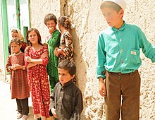
As of 2020, the population of the province is about 1,054,087, which is a multi-ethnic rural society.[3] Dari-speaking Tajiks make up the majority followed by a few Uzbeks, Hazaras, Pashtuns, Kyrgyz, Qizilbash, and others.[16] There are also speakers of the following Pamiri languages: Shughni, Munji, Ishkashimi, and Wakhi.
The inhabitants of the province are mostly Sunni Muslims, although there are also some Ismaili Shias.
Historical population estimates for Badakhshan province are as follows:[17]
Districts[]
| District | Capital | Population[2] | Area | Villages Ethnic groups |
|---|---|---|---|---|
| Arghanj Khwa | 18,520 | Tajik.[18] | ||
| Argo | 90,165 | 1,032 km2 | 145 villages.Tajik.[18] | |
| Baharak | Baharak | 33,119 | 328 km2 | 51 villages. Tajik.[18] |
| Darayim | 70,834 | 570 km2 | 101 villages. Tajik.[18] | |
| Fayzabad | Fayzabad | 78,757 | 514 km2 | 175 villages. Tajik.[18] |
| Ishkashim | Ishkashim | 15,951 | 1,123 km2 | 43 villages.[19] |
| Jurm | 43,445 | 1286 km2 | 75 villages. Tajik[18] | |
| Khash | 43,798 | 264 km2 | 21 villages. Tajik[18] | |
| Khwahan | Khwahan | 19,060 | 80 km2 | 46 villages. Tajik.[20] |
| Kishim | Mashhad | 93,004 | 264 km2 | 100 villages. Tajik[18] |
| Kohistan | 19,061 | 13 villages. Tajik[18] | ||
| Kuf Ab | Qal`eh-ye Kuf | 25,684 | Tajik | |
| Keran wa Menjan | Keran wa Menjan | 10,949 | 1,588 km2 | 42 villages. 100% Tajik.[21] |
| Maimay | Jamarj-e Bala | 30,416 | ||
| Nusay | Nusay | 26,631 | 4,589 km2 | 16 villages. Tajik.[22] |
| Raghistan | Ziraki | 45,556 | 25 villages. Tajik.[18] | |
| Shahri Buzurg | Shahri Buzurg | 60,155 | 956 km2 | 74 villages.[23] |
| Sheghnan | Shughnan | 27,750 | 3528 km2 | 28 villages. Khowar, Tajik and Qizilbash.[24] |
| Shekay | Jarf | 30,280 | 1,700 km2 | 38 villages. Tajik, etc.[25] |
| Shuhada | 39,742 | 1,521 km2 | 62 villages. 99% Tajik and 1% others.[26] | |
| Tagab | 32,307 | |||
| Tishkan | 34,336 | 812 km2 | 57 villages. Tajik.[18] | |
| Wakhan | Khandud | 17,167 | 10,953 km2 | 110 villages. Tajik.[27] |
| Warduj | 25,144 | 929 km2 | 45 villages. Tajik.[18] | |
| Yaftali Sufla | 60,695 | 605 km2 | 93 villages. Tajik.[18] | |
| Yamgan | 29,604 | 1,779 km2 | 39 villages. 100% Tajik[28] | |
| Yawan | 37,310 | |||
| Zebak | Zebak | 9,057 | 1,521 km2 | 62 villages. 99% Tajik and 1% others.[29] |
Notable people from Badakhshan[]
- Makhfi Badakhshi, Persian poetess, lived and died in Badakhshan
- Nūr al-Dīn Jaʿfar Badakhshī, 14th-century disciple of the eminent Central Asian Ṣūfī shaykh Sayyid ʿAlī Hamadānī[30]
- Mullah Shah Badakhshi, 17th-century Muslim Sufi of the Qadiri order, from Araska in Rustaq area in Badakhshan[31]
- Tahir Badakhshi, political activist
- Nāsir Khusraw Qubādiyānī Balkhi, 11th-century Persian poet, philosopher and Isma'ili scholar, died in Yamgan, Badakhshan
- Bairam Khan, 16th-century important military commander, and later commander-in-chief of the Mughal army, a powerful statesman and regent at the court of the Mughal Emperors, Humayun and Akbar
- Fawzia Koofi, noted Afghan women's rights activist, member of Parliament and 2014 presidential candidate
- Ustad Ahmad Lahauri, Chief architect of the Taj Mahal
- Miri Maftun, Afghan musician from Badakhshan.
- Zulmai Mujadidi, Member of Parliament representing Badakhshan
- Nasratullah Nasrat, Afghan cricketer
- Latif Pedram, political activist and candidate for Afghanistan's presidency
- Burhanuddin Rabbani, leader of the Jamiat-e Islami political party and former president of Afghanistan
See also[]
References[]
- ^ "Afghanistan Provinces". www.statoids.com.
- ^ Jump up to: a b "Estimated Population of Afghanistan 2021-22" (PDF). National Statistic and Information Authority (NSIA). April 2021. Retrieved 21 June 2021.
- ^ Jump up to: a b "Estimated Population of Afghanistan 2020-21" (PDF). Islamic Republic of Afghanistan, National Statistics and Information Authority. Retrieved 6 June 2021.
- ^ "BADAKŠĀN". www.iranica.com (آنلاین ed.). Archived from the original on 2 January 2009.
- ^ Eilers, W. "BADAKŠĀN". Encyclopædia Iranica (Online ed.). United States: Columbia University. Archived from the original on 2 January 2009. Retrieved 21 August 2018.
- ^ "404: Page not found" (PDF). CMI - Chr. Michelsen Institute. Cite uses generic title (help)
- ^ "The 2015 Insurgency in the North (2): Badakhshan's Jurm district under siege". 14 September 2015.
- ^ USGS. "M7.5 – 45 km E of Farkhar, Afghanistan". United States Geological Survey.
- ^ Jump up to: a b c d Archive, Civil Military Fusion Centre Archived 30 May 2014 at archive.today
- ^ Deer, William A.; Howie, Robert A, and Zussman, Joseph (1963) "Lapis lazuli" Rock-Forming Minerals Longman, London, OCLC 61975619
- ^ Lapis lazuli was also found in the Urals Mountains in Russia. Deer et al. above
- ^ Entekhabi-Fard, Camelia (15 October 2002). "Northern Alliance Veteran Hopes Emeralds Are Key Part of Afghanistan's Economic Recovery". Eurasia Insight. Archived from the original on 8 July 2007. Retrieved 20 August 2007.
- ^ Jump up to: a b "Afghanistan's gemstones" (PDF). Planet Earth. Winter 2006. Archived from the original (PDF) on 11 September 2008. Retrieved 20 August 2008.
- ^ Hamdard, Hidayatullah (20 January 2014). "Karzai assigns team to probe azure mine issue". Pajhwok Afghan News. Retrieved 20 January 2014.
- ^ Mackenzie, James; Qadir Sediqi, Abdul (7 October 2018). "Afghanistan signs major mining deals in development push". Reuters. Retrieved 30 June 2020.
- ^ "1 Badakhshan". Rkabuli.20m.com. Retrieved 22 May 2012.
- ^ Andrew Ross (ross@undpafg.org.pk. "Afghanistan Geographic & Thematic Layers". Fao.org. Retrieved 22 May 2012.
- ^ Jump up to: a b c d e f g h i j k l m نت, العربية (15 January 2019). "تاجیکهای افغانستان را بشناسید". العربية نت (in Persian). Retrieved 28 July 2020.
- ^ "Ishkashim District" (PDF).
- ^ "Khowahan District" (PDF).
- ^ "Keran Wa Menjan District" (PDF).
- ^ "Nusay District" (PDF).
- ^ "Shahr-e-Bozorg District" (PDF).
- ^ "Sheghnan District" (PDF).
- ^ Shekay District
- ^ "Shuhada District" (PDF).
- ^ "Wakhan District" (PDF).
- ^ "Yamgan District" (PDF).
- ^ "Zibak District" (PDF).
- ^ DeWeese, Devin A. (4 May 2016). "Badakhshī, Nūr al-Dīn Jaʿfar". Encyclopaedia of Islam, THREE.
- ^ "BADAḴŠĪ, MOLLĀ SHAH". Encyclopedia Iranica.
Further reading[]
- Burhanuddin Kushkaki. Rāhnamā-yi Qaṭaghan va Badakhshān. Kabul: Vizarat-i Ḥarbiyah, 1923.
- Jan-Heeren Grevemeyer: Herrschaft, Raub und Gegenseitigkeit: Die politische Geschichte Badakhshans 1500–1883, Otto Harrassowitz, Wiesbaden 1982
- Wolfgang Holzwarth: Segmentation und Staatsbildung in Afghanistan: Traditionale sozio-politische Organisation in Badakhshan, Wakhan und Sheghnan In: Berliner Institut für vergleichende Sozialforschung [Red.: Kurt Greussing u. Jan-Heeren Grevemeyer] (Hrsg.): Revolution in Iran und Afghanistan – mardom nameh – Jahrbuch zur Geschichte und Gesellschaft des Mittleren Orients Syndikat, Frankfurt am Main 1980, ISBN 3-8108-0147-X.
External links[]
 Media related to Badakhshan Province at Wikimedia Commons
- Badkhshan Province – Ministry of Rural Rehabilitation and Development
| show Places adjacent to Badakhshan Province |
|---|

| show Authority control |
|---|
- Badakhshan Province
- Provinces of Afghanistan
- Provinces of the Islamic Republic of Afghanistan