Transport in Afghanistan


Transport in Afghanistan has steadily improved in the last decade. Much of the nation's road network was built during the 1960s but left to ruin during the 1980s and 90s wars. New national highways, roads, and bridges have been rebuilt in the last decade to help increase travel as well as trade with neighboring countries. In 2008, there were about 700,000 vehicles registered in Kabul.[1][2]
Landlocked Afghanistan has no seaports, but the Amu Darya river, which forms part of the nation's border with Turkmenistan, Uzbekistan, and Tajikistan, does have substantial traffic. Rebuilding of airports, roads, and rail services has led to rapid economic growth in recent years. The nation has about 46 airports as of 2020.[3]
Road[]


Most major roads were built in the 1960s with assistance from the United States and the Soviet Union. The Soviets built a road and tunnel through the Salang pass in 1964, connecting northern and eastern Afghanistan. A highway connecting the principal cities of Herat, Mazar-i-Sharif, Lashkar Gah, Kandahar, Ghazni, Kabul and Jalalabad, with links to highways in neighboring Pakistan originally formed the primary road system of Afghanistan.
Afghanistan currently has 17,903 kilometers of paved roads and 17,000 kilometers of unpaved roads, for an approximate total road system of 34,903 kilometers.[3] Traffic in Afghanistan is right hand. In 2008, about 731,607 vehicles were registered in Kabul.[1] Many vehicles in the country are driven without registration plates. The Afghan government passed a law banning the import of cars older than 10 years. Toyota Corolla has been the most widely used vehicle in the country since the mid-1990s.[2] Afghanistan recently began manufacturing its own cars for domestic consumers.[4][5]
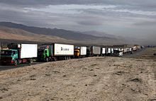
Long distant road journeys are made by company-owned Mercedes-Benz coach buses or various types of vans, trucks and private cars.[6] Although a nationwide bus service is available between major cities (Milli Bus), flying is more preferable by business people and the upper class. There are occasional highway robberies by bandits or militant groups. The roads are also dangerous due to accidents and lack of security forces.
Highways[]
The highway system is currently going through a reconstruction phase. Most of the regional roads are also being repaired or improved. For the last 30 years, the poor state of the Afghan transportation and communication networks has further fragmented and hampered the struggling economy.
The following is a partial list of national roads:
- Kabul-Kandahar Highway (A-1)
- Kabul-Jalalabad Road (A-1), which links the national capital to the eastern city of Jalalabad and the Pakistani border at Torkham
- (A-77)
- (A-76)
- [7]
- Kandahar-Herat Highway
- Route Trident (Lashkar Gah to Gereshk)
- Route 606 (Afghanistan)
- Gardez-Pathan Highway in Paktia Province (still under construction as of February 2015)
Borders[]
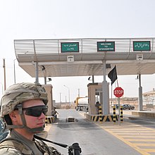
The Afghanistan-Tajikistan bridge at Sher Khan Bandar-Panji Poyon connects by road Afghanistan and Tajikistan. It was built by the United States Army Corps of Engineers (USACE) in 2007.[8] The two countries are also connected by the smaller Tajik–Afghan bridge at Tem-Demogan. The Afghanistan–Uzbekistan Friendship Bridge connects Afghanistan by road with Uzbekistan. There are similar road connections between Afghanistan and its other neighbors. The Delaram-Zaranj Highway was constructed with Indian assistance and was inaugurated in January 2009.[9]
Taxis, rickshaws and urban public transport[]
Due to the lack of public urban transport systems, taxis and rickshaws are highly popular in all the major cities, the latter especially in Jalalabad. Kabul demanded a much needed public transport system in the 21st century with a rapid increase in traffic and population, but many projects were canceled or did not complete. The municipality finally launched the city's first in decades, a bus system accompanied by bus stops, in March 2021.[10]
Animal powered[]

In rural areas and small towns, animals such as horses and donkeys are used for the purposes of transportation. Donkeys are popularly used by the Kuchi (nomadic) people.
Rail[]
Afghanistan-Iran rail connections[]
A rail line from Khaf in Iran to the city of Herat in Afghanistan has been under construction since 2006.[11] The Iranian line is a 1,435 mm (4 ft 8+1⁄2 in) standard gauge.[12] It was reported in December 2020 that the Herat-Khaf railway, which is 225 km long, had finally been completed.[13][14][15][16][17]
Afghanistan-Turkmenistan rail connections[]
A 10-kilometer-long 1,520 mm (4 ft 11+27⁄32 in) broad gauge line extends from Serhetabat in Turkmenistan to the town of Torghundi in Afghanistan, which is about 115 km to the north of Herat. An upgrade of this Soviet-built line, to renovate and connect the line from Torghundi to Herat, began in 2017.[18]
A second rail connection between the two countries is that which extends from Aqina dry port in Faryab Province of Afghanistan, via Imamnazar (or Ymamnazar), to Atamyrat (a.k.a. Kerki), where it connects with the Turkmen rail network.[19] The line extends from Aqina south to Andkhoy in Afghanistan, which is approximately 58 kilometres (36 mi) long.[20][21][22] It will be extended from Andkhoy in the future to other parts of Afghanistan.[23][24]
Afghanistan-Uzbekistan rail connections[]

There is a 75-kilometer-long rail line between Uzbekistan and the northern Afghan city of Mazar-i-Sharif, all of which is built to 1,520 mm (4 ft 11+27⁄32 in) broad gauge.[25] The line begins from Termez and crosses the Amu Darya river on the Soviet-built Afghanistan–Uzbekistan Friendship Bridge, finally reaching a site next to the Mazar-i-Sharif Airport. The Afghan government expects to have the rail line extended to Kabul and then to the eastern border town of Torkham, connecting with Pakistan Railways. The work is carried out by China Metallurgical Group Corporation (MCC).[26] For strategic reasons, past Afghan governments preferred to discourage the construction of railways, which could aid foreign interference in Afghanistan by Britain or Russia.[27] The river is the border between the two countries, and the stretch of track which lies within Afghanistan (from the Peace Bridge to the terminus near Herat airport is 75 km in length.
Pakistan border[]
Two broad gauge 1,676 mm (5 ft 6 in) Pakistan Railways lines terminate near the border at Chaman in Balochistan near the Khojak Pass; and at Torkham, the border town near the Khyber Pass. Various proposals exist to extend these lines on to Kandahar and Kabul respectively. In 2010, Pakistan and Afghanistan signed a Memorandum of understanding for going ahead with the laying of rail tracks between the two countries. Work on the proposed project was set to start in late 2010.[28]
Other borders[]
There are no rail links to China or Tajikistan, though a connection to the latter was proposed in 2008.[29]
Air[]


Air transport in Afghanistan is provided by Ariana Afghan Airlines, Afghan Jet International, East Horizon Airlines, Kam Air, Pamir Airways, and Safi Airways. Airlines from a number of nations also provide air services to fly in and out of the country. These include Air India, Emirates, Gulf Air, Iran Aseman Airlines, Pakistan International Airlines, Turkish Airlines and others.
The nation has at least four international airports. They include the Hamid Karzai International Airport in Kabul, the Ahmad Shah Baba International Airport in Kandahar; the Khwaja Abdullah Ansari International Airport in Herat;[30] and the Maulana Jalaluddin International Airport in Mazar-i-Sharif. There are a total of about 46 airports as of 2020.[3] Twenty-nine of them have paved runways. Four of them have runways over 3,000 meters; three have runways between about 2,500 and 3,000 meters; eight have runways between 1500 and 2500 meters; and two have runways under 1000 meters.
- Hamid Karzai International Airport (3500 m runway) in Kabul is the nation's largest airport and the primary hub for international civilian flights.
- Ahmad Shah Baba International Airport (3200 m runway) in Kandahar is a dual-use airport serving southern Afghanistan.
- Maulana Jalaluddin International Airport (3100 m runway) in Mazar-i-Sharif is a dual-use airport serving the northern portion of the country.
- Khwaja Abdullah Ansari International Airport (2600 m runway) in Herat is the primary civil airport for the northwestern portion of the country.[30]
- Jalalabad Airport and Khost Airport serve eastern Afghanistan.
- Farah Airport serves the western part of the country.
- Bamyan Airport and Ghazni Airport serve the central parts of Afghanistan.
- Kunduz Airport and Fayzabad Airport serve the northeastern part of the country.
Bagram Air Base is only used for military purposes. Its runway can handle larger airliners such as Boeing 747s, C-5 Galaxy and C-17 Globemaster III military cargo planes. KBR and some other companies fly into and out of Bagram on a regular basis. The Afghan government is seeking to build a new international airport in the Mohammad Agha District of Logar Province.[31]
Heliports[]
In addition to the airports, there is one heliport in Afghanistan.[3]
Water[]
The chief inland waterway of land-locked Afghanistan is the Amu Darya River which forms part of Afghanistan's northern border. The river handles barge traffic up to about 500 metric tons. The main river ports are located at Kheyrabad and Shir Khan Bandar.
Pipelines[]
There are petroleum pipelines from Bagram into Uzbekistan and Shindand into Turkmenistan. These pipelines have been in disrepair and disuse for years. There are 180 kilometers of natural gas pipelines. The $10 billion Trans-Afghanistan Pipeline for delivering natural gas across Afghanistan into Pakistan is moving forward.
See also[]
References[]
- ^ Jump up to: a b "Afghanistan" (PDF). World Health Organization (WHO). Retrieved January 8, 2012.
- ^ Jump up to: a b "Afghanistan gives antiquated Toyotas a new life". Stars and Stripes. July 3, 2015. Retrieved 2020-10-09.
- ^ Jump up to: a b c d "Afghanistan". The World Factbook. United States: Central Intelligence Agency (CIA). Retrieved 2017-12-01.
- ^ Hameed Farzad, ed. (September 2, 2020). "Afghan firm eyes emerging middle class with new cars, trucks". Reuters. Retrieved 2020-10-09.
- ^ "Afghan Company Introduces Locally Made Vehicles". Voice of America. September 3, 2020. Retrieved 2020-10-09.
- ^ "Vehicles Rental in Afghanistan | Afghan Logistics". AfghanRentals.
- ^ "Afghanistan: Improved Roads Unlocks Access to Services and Opportunities". World Bank.
- ^ Afghanistan-Tajikistan Bridge Links Central, South Asia Archived 2009-08-31 at the Wayback Machine
- ^ "India hands over strategic highway to Afghanistan". The Hindu. 2007-07-12. Archived from the original on 2009-02-03.
- ^ https://km.gov.af/6060/%D8%A8%D8%B3%D9%87%D8%A7%DB%8C-%D8%B4%D9%87%D8%B1%DB%8C-%D8%B4%D8%A7%D8%B1%D9%88%D8%A7%D9%84%DB%8C-%DA%A9%D8%A7%D8%A8%D9%84-%D8%AF%D8%B1-%D8%B3%D8%B7%D8%AD-%D8%B4%D9%87%D8%B1-%D8%A2%D8%BA%D8%A7%D8%B2-%D8%A8%D9%87-%D9%81%D8%B9%D8%A7%D9%84%DB%8C%D8%AA-%DA%A9%D8%B1%D8%AF
- ^ Murray Hughes (2008-01-29). "Opening up Afghan trade route to Iran". Railway Gazette International.
- ^ "Modern construction methods mastered on Mashhad - Bafgh line". Railway Gazette International. 2007-07-01.
- ^ "Long-delayed Herat-Khaf rail link inaugurated". Pajhwok Afghan News. 10 December 2020. Retrieved 2020-12-20.
- ^ "Afghan, Iranian Leaders Hail 'Historic' Khaf-Herat Railway". Afghanistan: TOLOnews. 12 December 2020.
- ^ "Officials Inaugurate Khawaf-Herat Railway Line". Afghanistan: Khaama Press. 10 December 2020. Retrieved 2020-12-20.
- ^ خط آهن هرات- خواف بین افغانستان و ایران افتتاح شد on YouTube (Pajhwok Afghan News, Dec. 8, 2020)
- ^ Khaf - Herat on YouTube (Afghanistan Chamber of Commerce & Investment, Dec. 8, 2020)
- ^ Kakar, Javed Hamim (1 December 2017). "Construction of Turkmen-Afghan railroad begins". Pajhwok Afghan News. Retrieved 1 December 2017.
- ^ Salehai, Zarghona (28 November 2016). "Afghan-Turkmenistan railroad inaugurated". Pajhwok Afghan News. Retrieved 17 January 2017.
- ^ "Aqina-Andkhoi Railway Officially Inaugurated". Khaama Press. 14 January 2020. Retrieved 2021-01-17.
- ^ "Aqina-Andkhoi Railway Officially Opened". TOLOnews. 14 January 2020. Retrieved 2021-01-17.
- ^ "Aqina-Andkhoi railway line inaugurated, 3 projects signed". Pajhwok Afghan News. 14 January 2020. Retrieved 2021-01-17.
- ^ "Work on Afghanistan-Turkmenistan railroad begins". Pajhwok Afghan News. 16 June 2013.
- ^ Hejaab, Aslam (31 October 2016). "Work Begins On Aqina-Andkhoy Railway". ariananews.af. Retrieved 17 January 2017.
- ^ "First major Afghan railway opens". Railway Gazette International. 25 August 2011. Retrieved 25 August 2011.
- ^ Construction on Kabul-Torkham Railway to Start Soon, Ministry of Mines Says Archived 2013-11-09 at the Wayback Machine. Tamim Shaheer, October 18, 2011.
- ^ "Railways of Afghanistan | Afghan railroads, past, present and future". andrewgrantham.co.uk.
- ^ Pakistan, Afghanistan ink MoU on rail links by Javed Hamim Kakar, Pajhwok Afghan news, Jul 7, 2010 19:05. Footnote upgraded 2010-07-12.
- ^ "Pointers". Railway Gazette International. 2008-06-15. Archived from the original on 2012-05-27.
- ^ Jump up to: a b https://president.gov.af/en/president-ghani-names-herat-international-airport-after-khwaja-abdullah-ansari/
- ^ "Govt Plans to Build Intl Airport in Logar: Aviation Officials". TOLOnews. 11 February 2021. Retrieved 2021-02-26.
External links[]
| Wikimedia Commons has media related to Transport in Afghanistan. |
![]() This article incorporates public domain material from the CIA World Factbook document: "2010 edition".
This article incorporates public domain material from the CIA World Factbook document: "2010 edition".
| show Transport in Asia |
|---|
- Transport in Afghanistan