Landlocked country
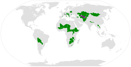
A landlocked country is a country that does not have territory connected to an ocean or whose coastlines lie on endorheic basins. There are currently 44 landlocked countries and 5 partially recognized landlocked states.[note 1][1] Kazakhstan is the world's largest landlocked country.[2]
In 1990, there were only 30 landlocked countries in the world. The breakup of Yugoslavia, the dissolutions of the Soviet Union and Czechoslovakia, and the independence referendums of Eritrea and South Sudan have created 15 new landlocked countries and 4 partially recognized landlocked states while the former landlocked country of Czechoslovakia ceased to exist on 1 January 1993.
Generally, being landlocked creates some political and economic handicaps that having access to international waters would avoid. For this reason, nations large and small throughout history have sought to gain access to open waters, even at great expense in wealth, bloodshed, and political capital.
The economic disadvantages of being landlocked can be alleviated or aggravated depending on degree of development, surrounding trade routes and freedom of trade, language barriers, and other considerations. Some landlocked countries are quite affluent, such as Andorra, Austria, Liechtenstein, Luxembourg, San Marino, Switzerland, and Vatican City, all of which, excluding Luxembourg, a founding member of NATO, frequently employ neutrality in global political issues. The majority, however, are classified as Landlocked Developing Countries (LLDCs).[3] Nine of the twelve countries with the lowest Human Development Indices (HDI) are landlocked.[4] International initiatives are aimed at reducing inequalities resulting from issues such as these, such as the United Nations Sustainable Development Goal 10 which aims to reduce inequality substantially by 2030.[5]
Significance[]
Historically, being landlocked has been disadvantageous to a country's development. It cuts a nation off from important sea resources such as fishing, and impedes or prevents direct access to maritime trade, a crucial component of economic and social advance. As such, coastal regions, or inland regions that have access to the World Ocean, tended to be wealthier and more heavily populated than inland regions that have no access to the World Ocean. Paul Collier in his book The Bottom Billion argues that being landlocked in a poor geographic neighborhood is one of four major development "traps" by which a country can be held back. In general, he found that when a neighboring country experiences better growth, it tends to spill over into favorable development for the country itself. For landlocked countries, the effect is particularly strong, as they are limited in their trading activity with the rest of the world. He states, "If you are coastal, you serve the world; if you are landlocked, you serve your neighbors."[6] Others have argued that being landlocked has an advantage as it creates a "natural tariff barrier" which protects the country from cheap imports. In some instances, this has led to more robust local food systems.[7][8]
Landlocked developing countries have significantly higher costs of international cargo transportation compared to coastal developing countries (in Asia the ratio is 3:1).[9]
Actions to avoid being landlocked[]
This section needs additional citations for verification. (August 2018) |
Countries have acted to overcome being landlocked by acquiring land that reaches the sea:
- The Republic of Ragusa, in 1699, gave the town of Neum to the Ottoman Empire because it did not want to have a land border with the Republic of Venice.[10] This small municipality was inherited by Bosnia and Herzegovina and now provides limited sea access, splitting the Croatian part of the Adriatic coast in two. Since Bosnia and Herzegovina is a new country, railways and ports have not been built for its need. There is no freight port along its short coastline at Neum, making it effectively landlocked, although there are plans to change this. Instead the port of Ploče in Croatia is used.
- The International Congo Society, which owned the territory now constituting the Democratic Republic of the Congo, was awarded a narrow piece of land cutting through Angola to connect it to the sea by the Conference of Berlin in 1885.
- After World War I, in the Treaty of Versailles, a part of Germany designated "the Polish corridor" was given to the new Second Polish Republic, for access to the Baltic Sea. This gave Poland a short coastline, but without a large harbour. This was also the pretext for making Danzig (now Gdańsk) with its harbour the Free City of Danzig, to which Poland was given free access. However, the Germans placed obstacles to this free access, especially when it came to military material. In response, the small fishing harbour of Gdynia was soon greatly enlarged.
- As a result of a 2005 territorial exchange with Ukraine, Moldova received a 600 metre (650 yard) long bank of the Danube River (which is an international waterway),[11] subsequently building its Port of Giurgiulești there.
Trade agreements[]
This section does not cite any sources. (August 2018) |
Countries can make agreements on getting free transport of goods through neighbor countries:
- The Treaty of Versailles required Germany to offer Czechoslovakia a lease for 99 years of parts of the ports in Hamburg and Stettin, allowing Czechoslovakia sea trade via the Elbe and Oder rivers. Stettin was annexed[12] by Poland after World War II, but Hamburg continued the contract so that part of the port (now called Moldauhafen) until 2019 could be used for sea trade by a successor of Czechoslovakia, the Czech Republic.
- The Danube is an international waterway, and thus landlocked Austria, Hungary, Moldova, Serbia, and Slovakia have secure access to the Black Sea (the same access is given to inland parts of Germany and Croatia, though Germany and Croatia are not landlocked). However, oceangoing ships cannot use the Danube, so cargo must be transloaded anyway, and many overseas imports into Austria and Hungary use land transport from Atlantic and Mediterranean ports. A similar situation exists for the Rhine river where Switzerland has boat access, but not oceangoing ships. Luxembourg has such through the Moselle, but Liechtenstein has no boat access, even though it is located along the Rhine, as the Rhine is not navigable that far upstream.
- The Mekong is an international waterway so that landlocked Laos has access to the South China Sea (since Laos became independent from French Indochina). However, it is not navigable above the Khone Phapheng Falls.
- Free ports allow transshipment to short-distance ships or river vessels.
- The TIR Treaty allows sealed road transport without customs checks and charges, mostly in Europe.
Political repercussions[]
This section needs additional citations for verification. (August 2018) |
Losing access to the sea is generally a great blow to a nation, politically, militarily, and economically. The following are examples of countries becoming landlocked.
- The independence of Eritrea, brought about by the 30-year Eritrean War of Independence,[13] caused Ethiopia to become landlocked in 1991. The Ethiopian Navy operated from foreign ports for several more years.
- Montenegro's decision to abandon the State Union of Serbia and Montenegro caused the federal unit of Serbia to become a landlocked current independent state.
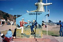
- Bolivia lost its coastline to Chile in the War of the Pacific and accepted it in treaties signed in 1884 and 1904. The last treaty gives port storage facilities and special treatment for the transit of goods from and to Bolivia through Chilean ports and territory. Peru and Argentina have also given special treatment for the transit of goods. A fluvial Bolivian Navy, which did not exist at the time of the War of the Pacific, was created later and both trains and operates in Lake Titicaca and rivers. The Bolivian people annually celebrate a patriotic "Dia del Mar" (Day of the Sea) to remember its territorial loss, which included both the coastal city of Antofagasta and what has proven to be one of the most significant and lucrative copper deposits in the world. Early in the 21st century, the selection of the route of gas pipes from Bolivia to the sea fueled popular uprisings, as people were against the option of laying the pipes through Chilean territory.
- Austria and Hungary also lost their access to the sea as a consequence of the Treaty of Saint-Germain-en-Laye (1919) and the Treaty of Trianon (1920) respectively. Previously, although Croatia had a limited constitutional autonomy within the Kingdom of Hungary, the City of Fiume/Rijeka on the Croatian coast was governed directly from Budapest by an appointed governor as a corpus separatum, to provide Hungary with its only international port in the periods 1779–1813, 1822–1848 and 1868–1918.
- By 1801, the Nizam's dominion of Hyderabad State assumed the shape it is now remembered for: that of a landlocked princely state with territories in central Deccan, bounded on all sides by British India, whereas 150 years earlier it had had a considerable coastline on the Bay of Bengal which was annexed by the British.[14]
- It is possible that one of the causes of the Paraguayan War was Paraguay's lack of direct ocean access (although this is disputed; see the linked article).
- When the Entente Powers divided the former Ottoman Empire under the Treaty of Sèvres at the close of World War I, Armenia was promised part of the Trebizond vilayet (roughly corresponding to the modern Trabzon and Rize provinces in Turkey). This would have given Armenia access to the Black Sea. However, the Sèvres treaty collapsed with the Turkish War of Independence and was superseded by the Treaty of Lausanne (1923), which firmly established Turkish rule over the area.
- In 2011, South Sudan broke off from Sudan, causing the former to become landlocked. There still remains conflict over the oil fields in South Sudan between the two countries.
The United Nations Convention on the Law of the Sea now gives a landlocked country a right of access to and from the sea without taxation of traffic through transit states. The United Nations has a programme of action to assist landlocked developing countries,[15] and the current responsible Undersecretary-General is Anwarul Karim Chowdhury.
Some countries have a long coastline, but much of it may not be readily usable for trade and commerce. For instance, in its early history, Russia's only ports were on the Arctic Ocean and frozen shut for much of the year. The wish to gain control of a warm-water port was a major motivator of Russian expansion towards the Baltic Sea, Black Sea and Pacific Ocean. On the other hand, some landlocked countries can have access to the ocean along wide navigable rivers. For instance, Paraguay (and Bolivia to a lesser extent) have access to the ocean through the Paraguay and Paraná rivers.
Several countries have coastlines on landlocked bodies of water, such as the Caspian Sea and the Dead Sea. Since these seas are in effect lakes without access to wider seaborne trade, countries such as Kazakhstan are still considered landlocked. Although the Caspian Sea is connected to the Black Sea via the man-made Volga–Don Canal, large oceangoing ships are unable to traverse it.
By degree[]
Landlocked countries may be bordered by a single country having direct access to the high seas, two or more such countries, or be surrounded by other landlocked countries, making a country doubly landlocked.
Landlocked by a single country[]
Three countries are landlocked by a single country (enclaved countries):
- Lesotho, a state surrounded by South Africa.
- San Marino, a state surrounded by Italy.
- Vatican City, a state surrounded by Italy.
Landlocked by two countries[]
Seven landlocked countries are surrounded by only two mutually bordering neighbours (semi-enclaved countries):
- Andorra (between France and Spain)
- Bhutan (between China and India)
- Eswatini (between Mozambique and South Africa)
- Liechtenstein (one of the "doubly landlocked" countries, between Austria and Switzerland)
- Moldova (between Romania and Ukraine)
- Mongolia (between China and Russia)
- Nepal (between China and India)
To this group could be added three landlocked territories which are de facto states with no or limited international recognition:[note 1]
- South Ossetia (between Georgia and Russia)
- Transnistria (between Moldova and Ukraine)
- West Bank (between Israel and Jordan)[16][17][18][19]
Doubly landlocked[]
A country is "doubly landlocked" or "double-landlocked" when it is surrounded only by landlocked countries (requiring the crossing of at least two national borders to reach a coastline).[20][21] There are two such countries:
- Liechtenstein in Western Europe, surrounded by Austria and Switzerland.[22]
- Uzbekistan in Central Asia, surrounded by Afghanistan, Kazakhstan, Kyrgyzstan, Tajikistan, and Turkmenistan.[23]
To this group could be added one doubly landlocked territory which is a de facto state with limited international recognition:
- Artsakh (also known as the Nagorno-Karabakh Republic) in the Caucasus, entirely surrounded by Azerbaijan except for a narrow land corridor to Armenia that is under the control of Russian peacekeepers. Formerly de facto bordering Iran and Armenia, it became doubly landlocked due to territorial losses suffered during the 2020 Nagorno-Karabakh War.
After the dissolution of the Holy Roman Empire, the Kingdom of Württemberg became a doubly landlocked state, bordering only Bavaria, Baden, and Switzerland. There were no doubly landlocked countries from the unification of Germany in 1871 until the end of World War I. Liechtenstein bordered the Austro-Hungarian Empire, which had an Adriatic coastline, and Uzbekistan was then part of the Russian Empire, which had both ocean and sea access.
With the dissolution of Austria-Hungary in 1918 and creation of an independent, landlocked Austria, Liechtenstein became the sole doubly landlocked country until 1938. In the Anschluss that year, Austria was absorbed into Nazi Germany, which possessed a border on the Baltic Sea and the North Sea. After World War II, Austria regained its independence and Liechtenstein once again became doubly landlocked.
Uzbekistan, which had been part of the Russian Empire and then the Soviet Union, gained its independence with the dissolution of the latter in 1991 and became the second doubly landlocked country.
However, Uzbekistan's doubly landlocked status depends on the Caspian Sea's status dispute: some countries, especially Iran and Turkmenistan, claim that the Caspian Sea should be considered as a real sea (mainly because this way they would have larger oil and gas fields), which would make Uzbekistan only a simple landlocked country since its neighbours Turkmenistan and Kazakhstan have access to the Caspian Sea.
List of landlocked countries and partially recognized landlocked states[]
| Country | Area (km2) | Population | Continent | Subregion | Surrounding countries | Count |
|---|---|---|---|---|---|---|
| Internationally recognized landlocked states | ||||||
| 652,230 | 33,369,945 | Asia | Southern Asia | China, Iran, Pakistan, Tajikistan, Turkmenistan, Uzbekistan | 6 | |
| 468 | 77,543 | Europe | Southern Europe | France and Spain | 2 | |
| 29,743 | 3,254,300 | Asia | Western Asia | Azerbaijan, Georgia, Iran, and Turkey | 4 or 5[c] | |
| 83,871 | 8,823,054 | Europe | Central Europe | Czech Republic, Germany, Hungary, Italy, Liechtenstein, Slovakia, Slovenia, and Switzerland | 8 | |
| 86,600 | 8,997,401 | Asia | Western Asia | Armenia, Georgia, Iran, Russia, and Turkey | 5 or 6[c] | |
| 207,600 | 9,484,300 | Europe | Eastern Europe | Latvia, Lithuania, Poland, Russia, and Ukraine | 5 | |
| 38,394 | 691,141 | Asia | Southern Asia | China and India | 2 | |
| 1,098,581 | 10,907,778 | Americas | South America | Argentina, Brazil, Chile, Paraguay, and Peru | 5 | |
| 582,000 | 1,990,876 | Africa | Southern Africa | Namibia, South Africa, Zambia, and Zimbabwe | 4 | |
| 274,222 | 15,746,232 | Africa | Western Africa | Benin, Côte d'Ivoire, Ghana, Mali, Niger, and Togo | 6 | |
| 27,834 | 10,557,259 | Africa | Eastern Africa | Democratic Republic of the Congo, Rwanda, and Tanzania | 3 | |
| 622,984 | 4,422,000 | Africa | Middle Africa | Cameroon, Chad, Congo, the Democratic Republic of the Congo, South Sudan, and Sudan | 6 | |
| 1,284,000 | 13,670,084 | Africa | Middle Africa | Cameroon, the Central African Republic, Libya, Niger, Nigeria, and Sudan | 6 | |
| 78,867 | 10,674,947 | Europe | Central Europe | Austria, Germany, Poland, and Slovakia | 4 | |
| 17,364 | 1,185,000 | Africa | Southern Africa | Mozambique and South Africa | 2 | |
| 1,104,300 | 101,853,268 | Africa | Eastern Africa | Djibouti, Eritrea, Kenya, Somalia, South Sudan, and Sudan | 6 | |
| 93,028 | 9,797,561 | Europe | Central Europe | Austria, Croatia, Romania, Serbia, Slovakia, Slovenia, and Ukraine | 7 | |
| 2,724,900 | 16,372,000 | Asia | Central Asia | China, Kyrgyzstan, Russia, Turkmenistan, and Uzbekistan | 5 | |
| 199,951 | 5,482,000 | Asia | Central Asia | China, Kazakhstan, Tajikistan, and Uzbekistan | 4 | |
| 236,800 | 7,123,205 | Asia | South-eastern Asia | Cambodia, China, Myanmar, Thailand, and Vietnam | 5 | |
| 30,355 | 2,067,000 | Africa | Southern Africa | South Africa | 1 | |
| 160 | 35,789 | Europe | Central Europe | Austria and Switzerland | 2 | |
| 2,586 | 502,202 | Europe | Central Europe | Belgium, France, and Germany | 3 | |
| 118,484 | 15,028,757 | Africa | Eastern Africa | Mozambique, Tanzania, and Zambia | 3 | |
| 1,240,192 | 14,517,176 | Africa | Western Africa | Algeria, Burkina Faso, Côte d'Ivoire, Guinea, Mauritania, Niger, and Senegal | 7 | |
| 33,846 | 3,559,500 | Europe | Eastern Europe | Romania, Transnistria[c], and Ukraine | 2 or 3[c] | |
| 1,566,500 | 2,892,876 | Asia | Eastern Asia | China and Russia | 2 | |
| 147,181 | 26,494,504 | Asia | Southern Asia | China and India | 2 | |
| 1,267,000 | 15,306,252 | Africa | Western Africa | Algeria, Benin, Burkina Faso, Chad, Libya, Mali, and Nigeria | 7 | |
| 25,713 | 2,114,550 | Europe | Southern Europe | Albania, Bulgaria, Greece, Kosovo[c], and Serbia | 4 or 5[c] | |
| 406,752 | 6,349,000 | Americas | South America | Argentina, Bolivia, and Brazil | 3 | |
| 26,338 | 10,746,311 | Africa | Eastern Africa | Burundi, the Democratic Republic of the Congo, Tanzania, and Uganda | 4 | |
| 61 | 31,716 | Europe | Southern Europe | Italy | 1 | |
| 88,361 | 6,926,705 | Europe | Southern Europe | Albania (via Kosovo and Metohija), Bosnia and Herzegovina, Bulgaria, Croatia, Hungary, Kosovo[c], Montenegro, North Macedonia, and Romania | 8 | |
| 49,035 | 5,429,763 | Europe | Central Europe | Austria, the Czech Republic, Hungary, Poland, and Ukraine | 5 | |
| 619,745 | 8,260,490 | Africa | Eastern Africa | Central African Republic, the Democratic Republic of the Congo, Ethiopia, Kenya, Sudan, and Uganda | 6 | |
| 41,284 | 8,401,120 | Europe | Central Europe | Austria, France, Germany, Italy, and Liechtenstein | 5 | |
| 143,100 | 7,349,145 | Asia | Central Asia | Afghanistan, China, Kyrgyzstan, and Uzbekistan | 4 | |
| 488,100 | 5,110,000 | Asia | Central Asia | Afghanistan, Iran, Kazakhstan, and Uzbekistan | 4 | |
| 241,038 | 40,322,768 | Africa | Eastern Africa | Democratic Republic of the Congo, Kenya, Rwanda, South Sudan, and Tanzania | 5 | |
| 449,100 | 32,606,007 | Asia | Central Asia | Afghanistan, Kazakhstan, Kyrgyzstan, Tajikistan, and Turkmenistan | 5 | |
| 0.44 | 826 | Europe | Southern Europe | Italy | 1 | |
| 752,612 | 12,935,000 | Africa | Eastern Africa | Angola, Botswana, the Democratic Republic of the Congo, Malawi, Mozambique, Namibia, Tanzania, and Zimbabwe | 8 | |
| 390,757 | 12,521,000 | Africa | Eastern Africa | Botswana, Mozambique, South Africa, and Zambia | 4 | |
| Partially recognized landlocked states | ||||||
| 3,170 | 120,000 | Asia | Western Asia | Azerbaijan | 1 | |
| 10,908 | 1,804,838 | Europe | Southern Europe | Albania, Montenegro, North Macedonia, and Serbia | 4 | |
| 3,900 | 72,000 | Asia | Western Asia | Georgia and Russia | 2 | |
| 4,163 | 505,153 | Europe | Eastern Europe | Moldova and Ukraine | 2 | |
| Total | 14,776,228 | 475,818,737 | N/A | |||
| Percentage of the World | 11.4% | 6.9% | ||||
- a Has a coastline on the saltwater Caspian Sea
- b Has a coastline on the saltwater Dead Sea
- c Not fully recognized
- d Landlocked by just one country
- e A part of the partially recognized State of Palestine
They can be grouped in contiguous groups as follows:[24]
- Eastern, Middle and Western African cluster (10): Burkina Faso, Burundi, the Central African Republic, Chad, Ethiopia, Mali, Niger, Rwanda, South Sudan, and Uganda
- Eastern, Southern and Western European cluster (9): Austria, the Czech Republic, Hungary, Kosovo (partially recognized), Liechtenstein, North Macedonia, Serbia, Slovakia, and Switzerland
- Southern Asian cluster (6): Afghanistan, Kazakhstan, Kyrgyzstan, Tajikistan, Turkmenistan, and Uzbekistan
- Eastern and Southern African group (4): Botswana, Malawi, Zambia, and Zimbabwe
- Western Asian group (3): Armenia and Azerbaijan
- South American group (2): Bolivia and Paraguay
Note:
- If Transnistria (unrecognized) is included, then Moldova and Transnistria form their own Eastern European group, listed in parentheses in the table.
- If it were not for the 40 km (25 mi) of coastline at Muanda, the Democratic Republic of the Congo would join the two African groups into one, making them the biggest contiguous group in the world.
- The Southern Asian cluster and the Western Asian group can be considered contiguous, joined by the landlocked Caspian Sea. Mongolia is almost part of this cluster too, being separated from Kazakhstan by only 30 km (19 mi), across Chinese or Russian territory.
There are the following 14 "single" landlocked countries (each of them borders no other landlocked country):
- Europe (6): Andorra, Belarus, Luxembourg, Moldova, San Marino, and Vatican City
- Asia (6): Bhutan, Laos, Mongolia, Nepal, South Ossetia (partially recognized), and the West Bank (a part of the partially recognized State of Palestine)
- Africa (2): Eswatini and Lesotho
Notes:
- If Transnistria (unrecognized) is included, then Moldova won't be considered a single landlocked country.
- If the West Bank (a part of the partially recognized State of Palestine) is included as a separate political entity, then Asia would have 6 single landlocked countries.
Landlocked countries by continent[]
If Azerbaijan, Kazakhstan, and South Ossetia are counted as part of Europe, then Europe has the most landlocked countries, at 19, including three partially recognized landlocked states. If these three transcontinental countries are included in Asia, then both Africa and Europe have the most, at 16. Depending on the status of the West Bank and the three transcontinental countries, Asia has between 11 and 15, including the unrecognized landlocked state of Artsakh. South America only has 2 landlocked countries. North America and Australia are the only continents with no landlocked countries (excluding Antarctica, which has no countries). Oceania (which is usually not considered a continent but a geographic region) also has no landlocked countries. Other than Papua New Guinea, which shares a land border with Indonesia (a transcontinental country), all the other countries in Oceania are island countries without a land border.
Except Bolivia and Paraguay, all the other landlocked countries are located in Afro-Eurasia. Very few island countries share a land border with another country; no island countries are landlocked.
Notes[]
- ^ Jump up to: a b Including the West Bank, which is claimed and partially administered as a part of the partially recognized State of Palestine.
See also[]
- Convention on Transit Trade of Land-locked States
- Declaration recognising the Right to a Flag of States having no Sea-coast
- Enclave and exclave
- Island country
- List of countries and territories by land and maritime borders
- List of countries that border only one other country
- Navies of landlocked countries
References[]
- ^ 44 Landlocked Countries Without Direct Ocean Access
- ^ "Largest LLC". United Nations Conference on Trade and Development.
- ^ Paudel, R. C. (2012). "Landlockedness and Economic Growth: New Evidence" (PDF). Growth and Export Performance of Developing Countries: Is Landlockedness Destiny?. Canberra, Australia: Australian National University. pp. 13–72.
- ^ Faye, M. L.; McArthur, J. W.; Sachs, J. D.; Snow, T. (2004). "The Challenges Facing Landlocked Developing Countries". Journal of Human Development. 5 (1): 31–68 [pp. 31–32]. doi:10.1080/14649880310001660201. S2CID 10442596.
- ^ "Goal 10 targets". UNDP. Retrieved 2020-09-23.
- ^ Collier, Paul (2007). The Bottom Billion. New York: Oxford University Press. pp. 56, 57. ISBN 978-0-19-537338-7.
- ^ Moseley, W. G.; Carney, J.; Becker, L. (2010). "Neoliberal Policy, Rural Livelihoods and Urban Food Security in West Africa: A Comparative Study of The Gambia, Côte d'Ivoire and Mali". Proc. Natl. Acad. Sci. USA. 107 (13): 5774–5779. Bibcode:2010PNAS..107.5774M. doi:10.1073/pnas.0905717107. PMC 2851933. PMID 20339079.
- ^ Moseley, W. G. (2011). "Lessons from the 2008 Global Food Crisis: Agro-Food Dynamics in Mali". Development in Practice. 21 (4–5): 604–612. doi:10.1080/09614524.2011.561290. S2CID 153852580.
- ^ United Nations Conference on Trade and Development (UNCTAD) (2010). Review of Maritime Transport, 2010 (PDF). New York and Geneva: United Nations. p. 160. ISBN 978-92-1-112810-9.[permanent dead link]
- ^ Jennings, Ken (19 September 2016). "This Country's Coastline Is So Short, You Could Walk It in A Day". Condé Nast Traveler. Retrieved 2021-01-04.
- ^ "Danube River Basin". International Waterway Governance. Retrieved June 30, 2018.)
- ^ Martin, McCauley (2017). The Cold War 1949-2016. New York: Routledge. pp. 4, 5, 6. ISBN 9781315213309.
- ^ Iyob, Ruth (1997). The Eritrean Struggle for Independence - Domination, resistance, nationalism 1941-1993. Cambridge: Cambridge University Press. pp. 11–25. ISBN 0-521-47327-6.
- ^ Chopra, P. N.; Puri, B. N.; Das, M. N. A Comprehensive History of India. 3. p. 298.
- ^ UN Report Archived 2011-09-28 at the Wayback Machine
- ^ Sweileh, Waleed M.; Al-Jabi, Samah W.; Sawalha, Ansam F.; Zyoud, Sa'ed H. (2009-04-07). "Pharmacy Education and Practice in West Bank, Palestine". American Journal of Pharmaceutical Education. 73 (2): 38. doi:10.5688/aj730238. ISSN 0002-9459. PMC 2690900. PMID 19513177.
The West Bank is a landlocked territory on the west bank of the Jordan River in the Middle East.
- ^ Daghara, Azza; Al-Khatib, Issam A.; Al-Jabari, Maher (2019-06-23). "Quality of Drinking Water from Springs in Palestine: West Bank as a Case Study". Journal of Environmental and Public Health. 2019: 1–7. doi:10.1155/2019/8631732. ISSN 1687-9805. PMC 6612393. PMID 31341486.
The West Bank is a landlocked region close to the Mediterranean shoreline of Western Asia
- ^ Musaee, Anwar H. M.; Abbas, Eeman Muhammad; Mujani, Wan Kamal; Sidik, Roziah (2014). "Financial Analysis of Waqf Real Estate Revenues in the West Bank: 1994-2014". Asian Economic and Financial Review. 4 (10): 1260–1274.
The West Bank is a landlocked territory near the eastern Mediterranean coast
- ^ Sperti, Luigi. "Instruments and Methods for the Survey and Analysis of Amphitheatres". doi:10.1515/9789048519590-038. hdl:10278/3684456.
The West Bank is a landlocked territory bordering Jordan
Cite journal requires|journal=(help) - ^ Dempsey Morais, Caitlin. "Landlocked Countries". Geolounge. Retrieved November 4, 2015.
- ^ "Landlocked Countries". About.com. Retrieved November 4, 2015.
- ^ "IGU regional conference on environment and quality of life in central Europe". GeoJournal. 28 (4). 1992. doi:10.1007/BF00273120. S2CID 189889904.
- ^ CIA World Factbook Uzbekistan
- ^ MacKellar, Landis; Wörgötter, Andreas; Wörz, Julia. "Economic Development Problems of Landlocked Countries" (PDF). Wien Institute for Advanced Studies. p. 12.
| hide Authority control | |
|---|---|
| General | |
| National libraries | |
| Other | |
- Landlocked countries
- Physical geography
- Country classifications