Transport in Malaysia
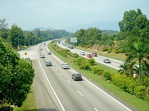
Transportation in Malaysia started to develop during British colonial rule, and the country's transport network is now diverse and developed. Malaysia's road network is extensive, covering 250,023 kilometres, including 1,956 km of expressways (in 2019). The main highway of the country extends over 800 km, reaching the Thai border from Singapore. Peninsular Malaysia has an extensive road network, whilst the road system in East Malaysia is not as well-developed. The main modes of transport in Peninsular Malaysia include buses, trains, cars, motorcycles (including Perlis and Kedah) and to an extent, commercial travel on airplanes.
Malaysia has six international airports. The official airline of Malaysia is Malaysia Airlines, providing international and domestic air service alongside two other carriers. Most of the major cities are connected by air routes. The railway system is state-run, and covers a total of 1,849 km. Popular within the cities are commuter rail and rapid transit, which reduces the traffic load on other systems, and is considered safe, comfortable and reliable.
Land[]
Roads[]
Malaysia's road network covers 250,023 kilometres (155,357 mi), of which 248,067 kilometres (154,142 mi) is paved/unpaved roads, and 1,957 kilometres (1,216 mi) is expressways.[1] The longest highway of the country, the North–South Expressway, extends over 800 kilometres (500 mi) between the Thai border and Singapore. The Second longest highway is East-Coast Highway (LPT-E8) Spanning almost 500 km from Kuala Lumpur to state capital of Terengganu, Kuala Terengganu. The road systems in Sabah and Sarawak are less developed and of lower quality in comparison to that of Peninsular Malaysia.[2] Recently, the construction of Pan-Borneo Highway is approved under 2015 Malaysian Budget.[3] The highway project spans 1,663 km (936 km in Sarawak, 727 km in Sabah) mostly mirror the existing trunk road, and it involves the widening of the present three-metre-wide single-carriageway into a dual-carriageway.[4][5] Driving on the left has been compulsory since the introduction of motor vehicles in Federated Malay States in 1903 during British colonial era. It is estimated that 9,432,023 passenger cars is actively using this road network in 2018.[6][7]
Railways[]
The railway system is state-run, and covers a total of 1,849 kilometres (1,149 mi). Most of the railway lines are consisted of ballasted setup, along with concrete sleepers, which serves better in wet and humid tropical condition, compared to wooden sleepers which can rot over time. As early as 1980s, due to the need for local suppliers of such products, a few local Malaysian rail manufacturing companies had been formed by collaboration with foreign technology partners.[8][9]
1,792 kilometres (1,113 mi) of it is metre gauge, while 199.5 kilometres (124 mi) is standard gauge. Seven hundred and sixty-seven kilometres of metre gauge tracks and all of the standard gauge tracks are electrified.[10] Intra-city travel is through relatively inexpensive rapid transit systems. Commuter rail and electric train service are available for most major cities, such as Kuala Lumpur.[11] Malaysia already approved her first Kuala Lumpur–Singapore High Speed Rail project spanning 375 km between Kuala Lumpur and Singapore.[12] This rapid development had spurred growth of local Malaysian rail service Companies which caters these niche needs.
Air[]


Airports[]
Malaysia has 62 airports, of which 38 are paved. The national airline is Malaysia Airlines, providing international and domestic air services. Major international routes and domestic routes crossing between West Malaysia and East Malaysia are served by Malaysia Airlines, AirAsia and Malindo Air while smaller domestic routes are supplemented by smaller airlines like MASwings, Firefly and Berjaya Air. Major cargo airlines include MASkargo and Transmile Air Services.
Kuala Lumpur International Airport is the main and busiest airport in Malaysia. In 2018, it was the world's 12th-busiest airport by international passenger traffic, recording over 43.5 million international passenger traffic. Other major airports include Kota Kinabalu International Airport, which is also Malaysia's second-busiest airport and busiest airport in East Malaysia with over 8.6 million passengers in 2018, and Penang International Airport, which serves Malaysia's second-largest urban area, with over 7.99 million passengers in 2018.
Airports with paved runways[]
total: 38
over 3,047 m: 5
2,438 to 3,047 m: 7
1,524 to 2,437 m: 10
914 to 1,523 m: 9
under 914 m: 7 (2004 est.)
Heliports[]
2 (2006 est.)
Airlines[]
National airline:
- Malaysia Airlines
Other airline:
Waterways[]
Malaysia has 7,200 kilometres (4,474 mi) of waterways,[10] most of them rivers. Of this, 3,200 kilometres (2,000 mi) are in Peninsular Malaysia, 1,500 kilometres (930 mi) are in Sabah, and 2,500 kilometres (1,600 mi) are in Sarawak.[10]
Ports and harbours[]

Malaysia is strategically located on the Strait of Malacca, one of the most important shipping lanes in the world. Malaysia has two ports that are listed in the top 20 busiest ports in the world, Port Klang and Port of Tanjung Pelepas, which are, respectively, the second- and third-busiest ports in Southeast Asia after the Port of Singapore. Port Klang is Malaysia's busiest port, and the thirteenth-busiest port in the world in 2013, handling over 10.3 million TEUs. Port of Tanjung Pelepas is Malaysia's second-busiest port, and the nineteenth-busiest port in the world in 2013, handling over 7.6 million TEUs.
This is a list of Malaysian ports and harbours:
- Bintulu
- Kota Kinabalu
- Kuantan
- Kemaman
- Kuching
- Kudat
- Labuan
- Lahad Datu
- Lumut
- Miri
- Pasir Gudang
- Penang
- Port Dickson
- Port Klang
- Sandakan
- Sibu
- Tanjung Berhala
- Tanjung Kidurong
- Tawau
- Tanjung Pelepas
- Kuala Kedah
Ferry[]
Merchant Marine[]
Total: 360 ships (1,000 GT or over) 5,389,397 GT/7,539,178 tonnes deadweight (DWT) by type: bulk 59, cargo 100, chemical tanker 38, container 66, liquefied gas 25, livestock carrier 1, passenger 2, petroleum tanker 56, roll on/roll off 5, vehicle carrier 8
Foreign-owned: China 1, Germany 2, Hong Kong 8, Indonesia 2, Japan 2, South Korea 1, Liberia 1, Monaco 1, Norway 1, Philippines 2, Singapore 81, Vietnam 1
registered in other countries: 75 (2009 est.)
Pipelines[]
Malaysia has 3 kilometres (2 mi) of condensate pipeline, 1,965 kilometres (1,221 mi) of gas pipeline, 31 kilometres (19 mi) of oil pipeline, and 114 kilometres (71 mi) of refined products pipelines.[10]
See also[]
- List of airports in Malaysia
- Kuala Lumpur–Singapore High Speed Rail
- Public transport in Kuala Lumpur
- Transportation in Kuala Lumpur
Regulation:
- Road signs in Malaysia
- Puspakom, vehicle inspection
- Vehicle registration plates of Malaysia
References[]
- ^ Road Statistic 2019 by Public Works Department Malaysia
- ^ Mody, Ashoka (1997). Infrastructure strategies in East Asia: the untold story. Washington D.C.: The World Bank. p. 35. ISBN 0-8213-4027-1.
- ^ "Budget 2015: Contractors stand to benefit from Pan-Borneo Highway". The Star Online.
- ^ "Construction of Pan Borneo Highway begins Tuesday". The Star Online.
- ^ "Najib: Pan-Borneo Highway to be toll-free". Free Malaysia Today.
- ^ Azmi, Muhammad; Tokai, Akihiro (1 December 2017). "Electric vehicle and end-of-life vehicle estimation in Malaysia 2040". Environment Systems and Decisions. 37 (4): 451–464. doi:10.1007/s10669-017-9647-4. ISSN 2194-5411. S2CID 114572684.
- ^ Bin Azmi, Muhammad; ビン, アズミ (2017). "マルチプルレゾリューション - JaLC". japanlinkcenter.org: 45. doi:10.18910/61777. Retrieved 8 February 2019.
- ^ "Asie Sendirian Berhad". www.asie.com.my.
- ^ "Archived copy" (PDF). Archived from the original (PDF) on 6 October 2015. Retrieved 6 October 2015.
{{cite web}}: CS1 maint: archived copy as title (link) - ^ a b c d "Malaysia". Cia.gov. Retrieved 11 March 2014.
- ^ ; ; (2004). Malaysia, Singapore & Brunei. Lonely Planet. p. 10. ISBN 9781740593571.
- ^ "KL–Singapore high speed rail project to start in 2016". The Malaysian Insider.
| Wikimedia Commons has media related to Transport in Malaysia. |
| Bus service |
| ||||||||||||||||||||||
|---|---|---|---|---|---|---|---|---|---|---|---|---|---|---|---|---|---|---|---|---|---|---|---|
| Major bus hubs |
| ||||||||||||||||||||||
| Companies |
| ||||||||||||||||||||||
| Related topics |
| ||||||||||||||||||||||
| Automated fare collection | |||||||||||||||||||||||
| Commissions |
| ||||||||||||||||||||||
| Buses |
| ||||||||||||||||||||||
Italics indicate the project is under construction. | |||||||||||||||||||||||
| Overview |
| ||||||||||||||||||||||||
|---|---|---|---|---|---|---|---|---|---|---|---|---|---|---|---|---|---|---|---|---|---|---|---|---|---|
| Major Operators |
| ||||||||||||||||||||||||
| Inter-city rail |
| ||||||||||||||||||||||||
| Commuter rail |
| ||||||||||||||||||||||||
| Metro rail |
| ||||||||||||||||||||||||
| Border link |
| ||||||||||||||||||||||||
| Other rail |
| ||||||||||||||||||||||||
| Rolling Stock(s) & Manufacturer(s) |
| ||||||||||||||||||||||||
| Depots |
| ||||||||||||||||||||||||
| Related articles | |||||||||||||||||||||||||
Transport in Asia | |
|---|---|
| Sovereign states |
|
| States with limited recognition |
|
| Dependencies and other territories |
|
| |
- Transport in Malaysia